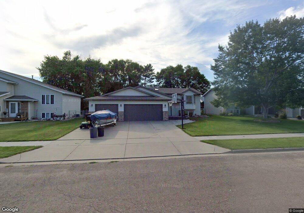
1956 Tahoe Dr Bismarck, ND 58504
Wachter NeighborhoodEstimated Value: $394,000 - $405,000
4
Beds
3
Baths
2,243
Sq Ft
$179/Sq Ft
Est. Value
About This Home
This home is located at 1956 Tahoe Dr, Bismarck, ND 58504 and is currently estimated at $401,362, approximately $178 per square foot. 1956 Tahoe Dr is a home located in Burleigh County with nearby schools including Victor Solheim Elementary School, Wachter Middle School, and Bismarck High School.
Ownership History
Date
Name
Owned For
Owner Type
Purchase Details
Closed on
Sep 24, 2009
Sold by
Gilpin James M and Gilpin Monna S
Bought by
Ukestad David M and Ukestad Kimberly J
Current Estimated Value
Home Financials for this Owner
Home Financials are based on the most recent Mortgage that was taken out on this home.
Original Mortgage
$188,522
Outstanding Balance
$124,911
Interest Rate
5.37%
Mortgage Type
FHA
Estimated Equity
$276,451
Purchase Details
Closed on
Sep 20, 2006
Sold by
Loven Timothy and Loven Amy
Bought by
Gillpin James M and Gillpin Monna S
Home Financials for this Owner
Home Financials are based on the most recent Mortgage that was taken out on this home.
Original Mortgage
$152,000
Interest Rate
6.49%
Mortgage Type
New Conventional
Create a Home Valuation Report for This Property
The Home Valuation Report is an in-depth analysis detailing your home's value as well as a comparison with similar homes in the area
Home Values in the Area
Average Home Value in this Area
Purchase History
| Date | Buyer | Sale Price | Title Company |
|---|---|---|---|
| Ukestad David M | $192,000 | -- | |
| Gillpin James M | $190,000 | Nd Guaranty Title Co |
Source: Public Records
Mortgage History
| Date | Status | Borrower | Loan Amount |
|---|---|---|---|
| Open | Ukestad David M | $188,522 | |
| Previous Owner | Gillpin James M | $152,000 |
Source: Public Records
Tax History
| Year | Tax Paid | Tax Assessment Tax Assessment Total Assessment is a certain percentage of the fair market value that is determined by local assessors to be the total taxable value of land and additions on the property. | Land | Improvement |
|---|---|---|---|---|
| 2024 | $3,629 | $171,800 | $35,000 | $136,800 |
| 2023 | $4,019 | $171,800 | $35,000 | $136,800 |
| 2022 | $3,488 | $160,500 | $35,000 | $125,500 |
| 2021 | $3,245 | $141,850 | $33,000 | $108,850 |
| 2020 | $3,090 | $135,750 | $33,000 | $102,750 |
| 2019 | $3,373 | $135,750 | $0 | $0 |
| 2018 | $3,143 | $135,750 | $33,000 | $102,750 |
| 2017 | $2,569 | $135,750 | $31,000 | $104,750 |
| 2016 | $2,569 | $135,750 | $24,000 | $111,750 |
| 2014 | -- | $122,600 | $0 | $0 |
Source: Public Records
Map
Nearby Homes
- 226 Laredo Dr
- 1701 Oakland Dr
- 310 Buckingham Place
- 449 Napa Loop
- 505 Yorkshire Ln
- 1620 Wichita Dr
- 1718 S Reno Dr
- 304 Napa Loop
- 1526 Oakland Dr
- 411 Live Oak Ln
- 314 Sussex St
- 1561 Wichita Dr
- 620 Bridgeport Dr Unit 1
- 616 Dover Dr
- 2330 Fresno Dr
- 10/11 Boston Dr
- 12/13 Boston Dr
- 20/21 Boston Dr
- 18/19 Boston Dr
- 16/17 Boston Dr
- 1964 Tahoe Dr
- 1948 Tahoe Dr
- 1959 Oakland Dr
- 1967 Oakland Dr
- 1951 Oakland Dr
- 1974 Billings Dr
- 1938 Tahoe Dr
- 1947 Tahoe Dr
- 1957 Tahoe Dr
- 1975 Oakland Dr
- 1965 Tahoe Dr
- 1943 Oakland Dr
- 1937 Tahoe Dr
- 1928 Tahoe Dr
- 1973 Tahoe Dr
- 1927 Tahoe Dr
- 1918 Tahoe Dr
- 1917 Oakland Dr
- 1938 San Diego Dr
- 1934 San Diego Dr
Your Personal Tour Guide
Ask me questions while you tour the home.