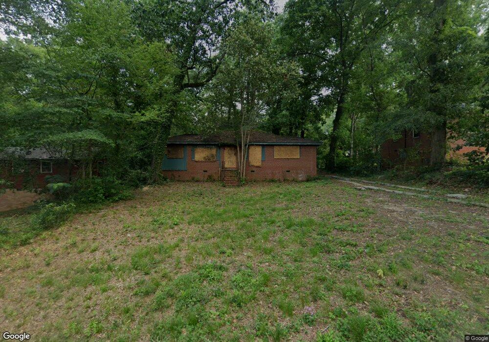
1957 Knightsbridge Rd Macon, GA 31211
Macon AreaEstimated Value: $69,179 - $130,000
About This Home
This home is located at 1957 Knightsbridge Rd, Macon, GA 31211 and is currently estimated at $98,295, approximately $65 per square foot. 1957 Knightsbridge Rd is a home located in Bibb County with nearby schools including Martin Luther King Jr. Elementary School, Appling Middle School, and Northeast High School.
Ownership History
We collect this data history from publicly available records. To have your information removed, we recommend requesting removal directly through your county’s website.
Purchase Details
Purchase Details
Purchase Details
Purchase Details
Purchase History
We collect this data history from publicly available records. To have your information removed, we recommend requesting removal directly through your county’s website.
| Date | Buyer | Sale Price | Title Company |
|---|---|---|---|
| -- | None Listed On Document | ||
| $6,000 | None Available | ||
| $82,400 | None Available | ||
| $10,500 | -- |
Mortgage History
We collect this data history from publicly available records. To have your information removed, we recommend requesting removal directly through your county’s website.
| Date | Status | Borrower | Loan Amount |
|---|---|---|---|
| Closed | $96,036 | ||
| Closed | $68,574 |
Tax History
We collect this data history from publicly available records. To have your information removed, we recommend requesting removal directly through your county’s website.
| Year | Tax Paid | Tax Assessment Tax Assessment Total Assessment is a certain percentage of the fair market value that is determined by local assessors to be the total taxable value of land and additions on the property. | Land | Improvement |
|---|---|---|---|---|
| 2025 | $332 | $13,498 | $4,160 | $9,338 |
| 2024 | $283 | $11,160 | $2,600 | $8,560 |
| 2023 | $277 | $9,342 | $1,560 | $7,782 |
| 2022 | $83 | $5,958 | $2,588 | $3,370 |
| 2021 | $215 | $5,665 | $1,650 | $4,015 |
| 2020 | $202 | $5,192 | $1,650 | $3,542 |
| 2019 | $203 | $5,192 | $1,650 | $3,542 |
| 2018 | $491 | $5,192 | $1,650 | $3,542 |
| 2017 | $195 | $5,192 | $1,650 | $3,542 |
| 2016 | $221 | $6,373 | $1,650 | $4,723 |
| 2015 | $659 | $13,458 | $1,650 | $11,808 |
| 2014 | $1,022 | $18,144 | $2,400 | $15,744 |
Map
- 2371 Kensington Rd
- 2371 Kensington Rd
- 2063 Bayswater Rd
- 2761 Walnut Creek Rd
- 2350 Ollie Dr
- 2675 Pauladale Dr
- 2721 Kensington Place
- 2585 New Clinton Rd
- 2256 Melton Ave
- 2230 Greenwood Dr
- 2265 Companion Dr
- 2792 Skyline Dr
- 2106 Melton Ave
- 2751 Horseshoe Dr
- 2837 Skyline Rd
- 2837 Skyline Dr
- 1818 Kinder Kare Dr
- 0 New Clinton Rd Unit 10755954
- 0 New Clinton Rd Unit 7763618
- 1177,1179,1183 Shurling Dr
- 1965 Knightsbridge Rd
- 1981 Knightsbridge Rd
- 1949 Knightsbridge Rd
- 1954 Bayswater Rd
- 1962 Baywater Rd
- 1962 Bayswater Rd
- 1989 Knightsbridge Rd
- 1954 Knightsbridge Rd
- 1946 Bayswater Rd
- 1970 Knightsbridge Rd Unit 213
- 1970 Knightsbridge Rd
- 1941 Knightsbridge Rd
- 1970 Bayswater Rd
- 1978 Knightsbridge Rd
- 1997 Knightsbridge Rd
- 1946 Knightsbridge Rd
- 1938 Bayswater Rd
- 1986 Knightsbridge Rd
- 1931 Knightsbridge Rd
- 2003 Knightsbridge Rd
Ask me questions while you tour the home.