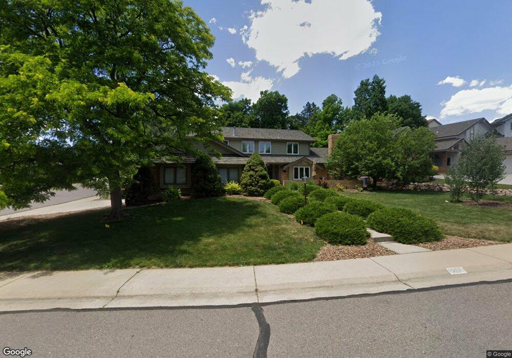
1957 S Queen Dr Lakewood, CO 80227
Green Mountain NeighborhoodEstimated Value: $982,770 - $1,151,000
4
Beds
7
Baths
2,843
Sq Ft
$364/Sq Ft
Est. Value
About This Home
This home is located at 1957 S Queen Dr, Lakewood, CO 80227 and is currently estimated at $1,034,193, approximately $363 per square foot. 1957 S Queen Dr is a home located in Jefferson County with nearby schools including Devinny Elementary School, Dunstan Middle School, and Green Mountain High School.
Ownership History
Date
Name
Owned For
Owner Type
Purchase Details
Closed on
Aug 4, 2005
Sold by
Basner Hans P and Basner Linda C
Bought by
Ramsey David G and Ramsey Deborah A
Current Estimated Value
Home Financials for this Owner
Home Financials are based on the most recent Mortgage that was taken out on this home.
Original Mortgage
$320,000
Outstanding Balance
$166,910
Interest Rate
5.55%
Mortgage Type
Fannie Mae Freddie Mac
Estimated Equity
$867,283
Purchase Details
Closed on
Dec 5, 1996
Sold by
Joon Lim Hong and Bun Lim Yung
Bought by
Basner Hans P and Basner Linda C
Home Financials for this Owner
Home Financials are based on the most recent Mortgage that was taken out on this home.
Original Mortgage
$100,000
Interest Rate
7.77%
Create a Home Valuation Report for This Property
The Home Valuation Report is an in-depth analysis detailing your home's value as well as a comparison with similar homes in the area
Home Values in the Area
Average Home Value in this Area
Purchase History
| Date | Buyer | Sale Price | Title Company |
|---|---|---|---|
| Ramsey David G | $485,000 | Land Title Guarantee Company | |
| Basner Hans P | $250,000 | Land Title |
Source: Public Records
Mortgage History
| Date | Status | Borrower | Loan Amount |
|---|---|---|---|
| Open | Ramsey David G | $320,000 | |
| Previous Owner | Basner Hans P | $100,000 |
Source: Public Records
Tax History Compared to Growth
Tax History
| Year | Tax Paid | Tax Assessment Tax Assessment Total Assessment is a certain percentage of the fair market value that is determined by local assessors to be the total taxable value of land and additions on the property. | Land | Improvement |
|---|---|---|---|---|
| 2024 | $5,163 | $56,590 | $26,450 | $30,140 |
| 2023 | $5,163 | $56,590 | $26,450 | $30,140 |
| 2022 | $4,343 | $46,455 | $21,925 | $24,530 |
| 2021 | $4,405 | $47,792 | $22,556 | $25,236 |
| 2020 | $4,117 | $44,825 | $21,089 | $23,736 |
| 2019 | $4,065 | $44,825 | $21,089 | $23,736 |
| 2018 | $3,987 | $42,475 | $15,453 | $27,022 |
| 2017 | $3,511 | $42,475 | $15,453 | $27,022 |
| 2016 | $3,586 | $40,438 | $11,169 | $29,269 |
| 2015 | $3,289 | $40,438 | $11,169 | $29,269 |
| 2014 | $3,289 | $33,989 | $10,189 | $23,800 |
Source: Public Records
Map
Nearby Homes
- 11165 W Asbury Ave
- 11465 W Atlantic Ave
- 1822 S Robb St
- 1865 S Union Blvd
- 1847 S Union Blvd Unit 36
- 1901 S Union Place
- 2154 S Parfet Dr
- 2064 S Robb Way
- 2252 S Queen St
- 10866 W Evans Ave Unit 56
- 10890 W Evans Ave Unit 2E
- 1577 S Pierson St
- 1799 S Van Gordon Ct
- 10490 W Jewell Ave Unit C
- 10490 W Jewell Ave Unit D
- 10430 W Jewell Ave Unit B
- 11904 W Auburn Dr
- 10390 W Evans Ave
- 1537 S Owens St Unit 31
- 10340 W Jewell Ave Unit C
- 1947 S Queen Dr
- 1978 S Parfet Dr
- 1975 S Parfet Dr
- 1937 S Queen Dr
- 1981 S Parfet Dr
- 1984 S Parfet Dr
- 1952 S Queen Dr
- 1933 S Queen Dr
- 1974 S Parfet Dr
- 1946 S Queen Dr
- 1971 S Parfet Dr
- 1927 S Queen Dr
- 1985 S Parfet Dr
- 1988 S Parfet Dr
- 1942 S Queen Dr
- 1939 S Robb Way
- 1968 S Parfet Dr
- 1965 S Parfet Dr
- 1923 S Queen Dr
- 1949 S Robb Way