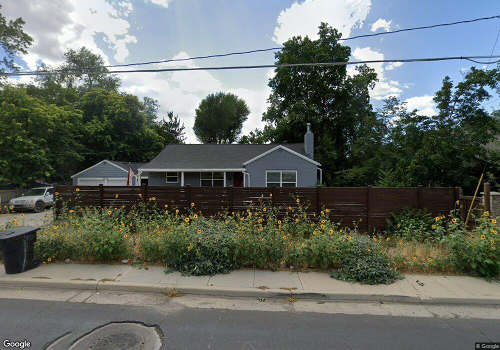
1957 Sutton Commons Cir Salt Lake City, UT 84121
Estimated Value: $874,000 - $1,284,000
4
Beds
3
Baths
2,695
Sq Ft
$389/Sq Ft
Est. Value
About This Home
This home is located at 1957 Sutton Commons Cir, Salt Lake City, UT 84121 and is currently estimated at $1,049,573, approximately $389 per square foot. 1957 Sutton Commons Cir is a home located in Salt Lake County with nearby schools including Oakwood Elementary School, Bonneville Junior High School, and Cottonwood High School.
Ownership History
Date
Name
Owned For
Owner Type
Purchase Details
Closed on
Oct 12, 2020
Sold by
Yasuo Keiji and Yasuo Kyoko
Bought by
Yasuo Keiji and Yasuo Kyoko
Current Estimated Value
Purchase Details
Closed on
May 16, 1994
Sold by
Taggart Paul S
Bought by
Yasuo Keiji and Yasuo Kyoko
Home Financials for this Owner
Home Financials are based on the most recent Mortgage that was taken out on this home.
Original Mortgage
$206,500
Interest Rate
8.52%
Create a Home Valuation Report for This Property
The Home Valuation Report is an in-depth analysis detailing your home's value as well as a comparison with similar homes in the area
Home Values in the Area
Average Home Value in this Area
Purchase History
| Date | Buyer | Sale Price | Title Company |
|---|---|---|---|
| Yasuo Keiji | -- | None Available | |
| Yasuo Keiji | -- | -- |
Source: Public Records
Mortgage History
| Date | Status | Borrower | Loan Amount |
|---|---|---|---|
| Previous Owner | Yasuo Keiji | $206,500 |
Source: Public Records
Tax History Compared to Growth
Tax History
| Year | Tax Paid | Tax Assessment Tax Assessment Total Assessment is a certain percentage of the fair market value that is determined by local assessors to be the total taxable value of land and additions on the property. | Land | Improvement |
|---|---|---|---|---|
| 2025 | $4,813 | $970,000 | $251,800 | $718,200 |
| 2024 | $4,813 | $871,700 | $244,100 | $627,600 |
| 2023 | $4,621 | $815,600 | $192,200 | $623,400 |
| 2022 | $0 | $810,000 | $188,400 | $621,600 |
| 2021 | $5,225 | $681,400 | $165,800 | $515,600 |
| 2020 | $4,381 | $673,600 | $162,000 | $511,600 |
| 2019 | $4,395 | $658,300 | $152,100 | $506,200 |
| 2018 | $0 | $609,100 | $152,100 | $457,000 |
| 2017 | $3,784 | $579,700 | $152,100 | $427,600 |
| 2016 | $3,685 | $568,000 | $152,100 | $415,900 |
| 2015 | $3,568 | $513,000 | $162,800 | $350,200 |
| 2014 | -- | $496,000 | $162,800 | $333,200 |
Source: Public Records
Map
Nearby Homes
- 5946 S Highland Dr
- 1963 E Charleston Ln
- 6048 S 2075 E
- 6056 S 2075 E
- 2105 Fardown Ave S
- 2113 E Fardown Ave
- 2225 Fardown Ave S
- 2138 E Pheasant Ln
- 5625 S Dunetree Hill Ln
- 5608 S Dunetree Hill Ln
- 1876 Jeremy Ct
- 1694 E Cannes Way
- 6187 S 2090 E
- 2209 E Fardown Ave
- 2225 E Fardown Ave
- 5780 S Minden Dr
- 6176 S Verness Cove
- 5841 S Fontaine Bleu Cir
- 2062 E Walker Ln
- 1870 E Monterey Dr Unit M55
- 1954 Sutton Commons Cir
- 5920 Highland Dr
- 1946 Charleston Ln
- 5920 S Highland Dr Unit 2
- 5920 S Highland Dr Unit 1
- 5920 S Highland Dr
- 1956 Charleston Ln
- 1941 E Sutton Commons Cir
- 1941 Sutton Commons Cir
- 1948 Charleston Ln
- 1954 E Sutton Commons Cir
- 1940 E Charleston Ln
- 1954 Charleston Ln
- 1964 E Charleston Ln
- 1962 E Charleston Ln
- 5924 S Highland Dr
- 5900 Highland Dr Unit 7
- 5900 Highland Dr Unit 8
- 1964 Charleston Ln
- 5924 Highland Dr