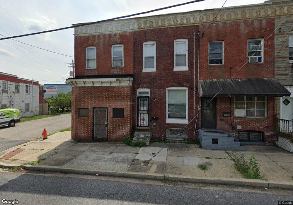
1958 Hollins Ferry Rd Baltimore, MD 21230
Morrell Park NeighborhoodEstimated Value: $69,614 - $120,000
1
Bed
2
Baths
1,308
Sq Ft
$72/Sq Ft
Est. Value
About This Home
This home is located at 1958 Hollins Ferry Rd, Baltimore, MD 21230 and is currently estimated at $94,807, approximately $72 per square foot. 1958 Hollins Ferry Rd is a home located in Baltimore City with nearby schools including Morrell Park Elementary/Middle School, Booker T. Washington Middle School, and Edmondson Westside High School.
Ownership History
Date
Name
Owned For
Owner Type
Purchase Details
Closed on
Jan 13, 2016
Sold by
Shields Milburn F and Shields Rita P
Bought by
Newman Tysha
Current Estimated Value
Purchase Details
Closed on
Dec 1, 2014
Sold by
Kelly Ruth Irene and Kelly Raymond Herman
Bought by
Shields Milburn F and Shields Rita P
Create a Home Valuation Report for This Property
The Home Valuation Report is an in-depth analysis detailing your home's value as well as a comparison with similar homes in the area
Home Values in the Area
Average Home Value in this Area
Purchase History
| Date | Buyer | Sale Price | Title Company |
|---|---|---|---|
| Newman Tysha | $30,000 | None Available | |
| Shields Milburn F | $21,225 | First American Title Ins Co |
Source: Public Records
Tax History Compared to Growth
Tax History
| Year | Tax Paid | Tax Assessment Tax Assessment Total Assessment is a certain percentage of the fair market value that is determined by local assessors to be the total taxable value of land and additions on the property. | Land | Improvement |
|---|---|---|---|---|
| 2025 | $908 | $39,333 | -- | -- |
| 2024 | $908 | $38,667 | $0 | $0 |
| 2023 | $897 | $38,000 | $7,000 | $31,000 |
| 2022 | $897 | $38,000 | $7,000 | $31,000 |
| 2021 | $897 | $38,000 | $7,000 | $31,000 |
| 2020 | $897 | $38,000 | $7,000 | $31,000 |
| 2019 | $893 | $38,000 | $7,000 | $31,000 |
| 2018 | $897 | $38,000 | $7,000 | $31,000 |
| 2017 | $1,513 | $64,100 | $0 | $0 |
| 2016 | $2,619 | $64,100 | $0 | $0 |
| 2015 | $2,619 | $64,100 | $0 | $0 |
| 2014 | $2,619 | $106,200 | $0 | $0 |
Source: Public Records
Map
Nearby Homes
- 1933 Griffis Ave
- 1915 Griffis Ave
- 2012 Griffis Ave
- 1919 Grinnalds Ave
- 1715 Spence St
- 2006 Grinnalds Ave
- 2305 Herkimer St
- 1703 - 1707 1/2 Spence St
- 1701 Spence St
- 2507 Washington Blvd
- 0 Harman Ave
- 2506 Washington Blvd
- 1707 Harman Ave
- 2104 Whistler Ave
- 1918 Parksley Ave
- 2410 Huron St
- 1962 Sponson St
- 2404 Puget St
- 2809 Washington Blvd
- 1733 Letitia Ave
- 1956 Hollins Ferry Rd
- 1954 Hollins Ferry Rd
- 1952 Hollins Ferry Rd
- 1950 Hollins Ferry Rd
- 1948 Hollins Ferry Rd
- 2002 Hollins Ferry Rd
- 1946 Hollins Ferry Rd
- 2004 Hollins Ferry Rd
- 2006 Hollins Ferry Rd
- 1944 Hollins Ferry Rd
- 2001 Hollins Ferry Rd
- 2008 Hollins Ferry Rd
- 1943 Hollins Ferry Rd
- 2007 Hollins Ferry Rd
- 1941 Hollins Ferry Rd
- 1939 Hollins Ferry Rd
- 1946 Maisel St
- 2219 Bremen St
- 1931 Hollins Ferry Rd
- 1936 Maisel St