Estimated Value: $514,000 - $562,000
3
Beds
3
Baths
1,506
Sq Ft
$352/Sq Ft
Est. Value
About This Home
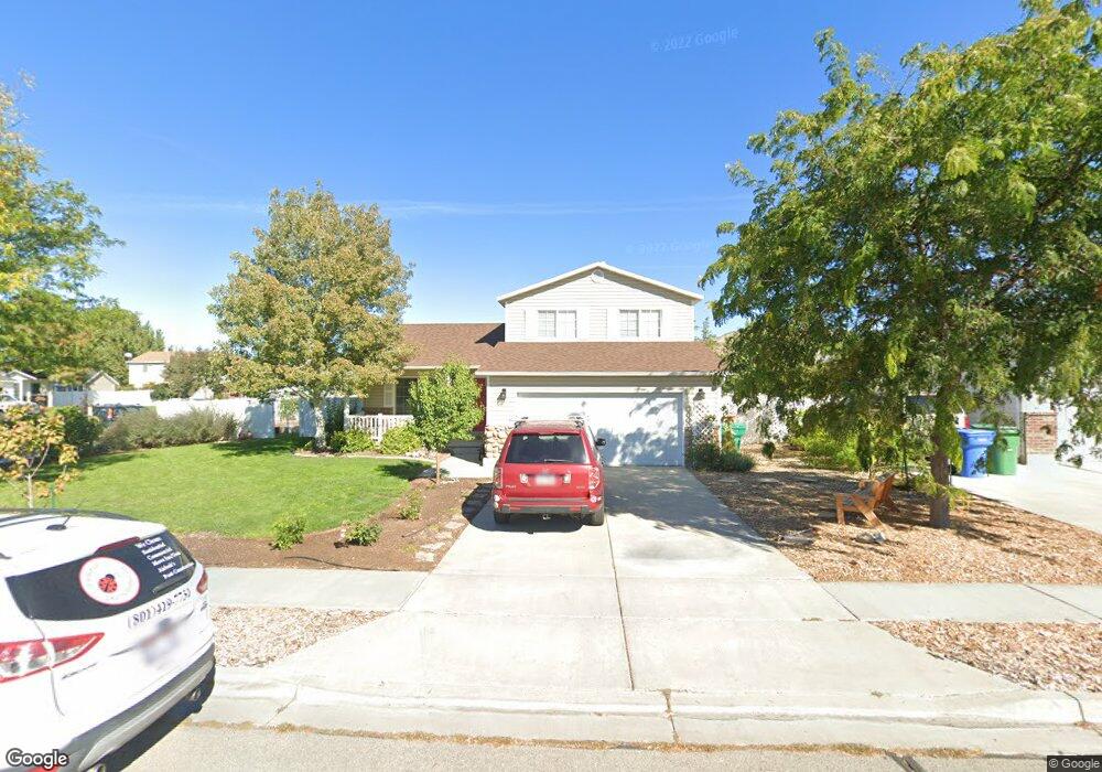
This home is located at 1958 W 1540 N, Lehi, UT 84043 and is currently estimated at $530,234, approximately $352 per square foot. 1958 W 1540 N is a home located in Utah County with nearby schools including North Point Elementary School, Willowcreek Middle School, and Lehi High School.
Ownership History
Date
Name
Owned For
Owner Type
Purchase Details
Closed on
Nov 14, 2022
Sold by
Jones Fredrick William and Jones Kirsten C
Bought by
Goel Pragya
Current Estimated Value
Home Financials for this Owner
Home Financials are based on the most recent Mortgage that was taken out on this home.
Original Mortgage
$423,000
Outstanding Balance
$410,192
Interest Rate
7.08%
Mortgage Type
New Conventional
Estimated Equity
$120,042
Purchase Details
Closed on
Jan 19, 2021
Sold by
Jones Fredrick W and Jones Kirsten C
Bought by
Jones Fredrick William and Jones Kirsten C
Home Financials for this Owner
Home Financials are based on the most recent Mortgage that was taken out on this home.
Original Mortgage
$284,800
Interest Rate
2.71%
Mortgage Type
New Conventional
Purchase Details
Closed on
Jan 25, 2018
Sold by
Dawson Gary W and Dawson Opal Annette
Bought by
Jones Fredrick W and Jones Kristen C
Home Financials for this Owner
Home Financials are based on the most recent Mortgage that was taken out on this home.
Original Mortgage
$257,050
Interest Rate
3.93%
Mortgage Type
New Conventional
Purchase Details
Closed on
May 16, 2017
Sold by
Matthews Rob and Matthews Amy
Bought by
Dawson Gary W and Dawson Opal Annette
Home Financials for this Owner
Home Financials are based on the most recent Mortgage that was taken out on this home.
Original Mortgage
$255,000
Interest Rate
4.1%
Mortgage Type
VA
Purchase Details
Closed on
Jul 14, 2016
Sold by
Giovannoni James D and Giovannoni Jennell
Bought by
Mathews Rob and Mathews Amy
Purchase Details
Closed on
Jun 28, 2001
Sold by
Murdock Adam A and Murdock Jeneen W
Bought by
Giovannoni James D
Purchase Details
Closed on
Jun 27, 2001
Sold by
Giovannoni James D
Bought by
Giovannoni James D and Giovannoni Jennell
Purchase Details
Closed on
May 5, 1999
Sold by
Salisbury Development Lc
Bought by
Murdock Adam A and Murdock Jeneen W
Home Financials for this Owner
Home Financials are based on the most recent Mortgage that was taken out on this home.
Original Mortgage
$120,765
Interest Rate
6.96%
Create a Home Valuation Report for This Property
The Home Valuation Report is an in-depth analysis detailing your home's value as well as a comparison with similar homes in the area
Home Values in the Area
Average Home Value in this Area
Purchase History
| Date | Buyer | Sale Price | Title Company |
|---|---|---|---|
| Goel Pragya | -- | Homie Title | |
| Jones Fredrick William | -- | Vanguard Title Insurance Age | |
| Jones Fredrick W | -- | Meridian Title Co | |
| Dawson Gary W | -- | Capstone Title & Escrow | |
| Mathews Rob | -- | Eagle Gate Title Ins Ag | |
| Giovannoni James D | -- | Sundance Title Insurance Ag | |
| Giovannoni James D | -- | Signature Title | |
| Murdock Adam A | -- | Provo Land Title Company |
Source: Public Records
Mortgage History
| Date | Status | Borrower | Loan Amount |
|---|---|---|---|
| Open | Goel Pragya | $423,000 | |
| Previous Owner | Jones Fredrick William | $284,800 | |
| Previous Owner | Jones Fredrick W | $257,050 | |
| Previous Owner | Dawson Gary W | $255,000 | |
| Previous Owner | Murdock Adam A | $120,765 |
Source: Public Records
Tax History Compared to Growth
Tax History
| Year | Tax Paid | Tax Assessment Tax Assessment Total Assessment is a certain percentage of the fair market value that is determined by local assessors to be the total taxable value of land and additions on the property. | Land | Improvement |
|---|---|---|---|---|
| 2025 | $2,006 | $250,910 | $194,100 | $262,100 |
| 2024 | $2,006 | $234,795 | $0 | $0 |
| 2023 | $1,852 | $235,290 | $0 | $0 |
| 2022 | $1,971 | $242,770 | $0 | $0 |
| 2021 | $1,748 | $325,600 | $112,300 | $213,300 |
| 2020 | $1,648 | $303,300 | $104,000 | $199,300 |
| 2019 | $1,449 | $277,300 | $104,000 | $173,300 |
| 2018 | $1,367 | $247,300 | $92,700 | $154,600 |
| 2017 | $1,326 | $127,545 | $0 | $0 |
| 2016 | $1,296 | $115,610 | $0 | $0 |
| 2015 | $1,264 | $107,085 | $0 | $0 |
| 2014 | $1,165 | $98,065 | $0 | $0 |
Source: Public Records
Map
Nearby Homes
- 1542 N 1900 W
- 1648 N 1900 W
- 1908 N 2230 W
- 1896 N 2230 W
- 1870 N 2230 W
- 1659 W Boxwood Dr Unit 109
- 1627 W Boxwood Dr Unit 110
- 1970 N 2090 St W
- Huntington Plan at Pioneer Meadows
- Silver Lake Plan at Pioneer Meadows
- Summit Plan at Pioneer Meadows
- Palisade Plan at Pioneer Meadows
- 1332 W 1500 N
- 2012 N 2040 W
- 1969 N 2040 St W
- 1968 N 2040 W
- 2013 N 2040 W
- 1990 N 2040 W
- 1127 N 1500 W
- 1302 N 2450 W