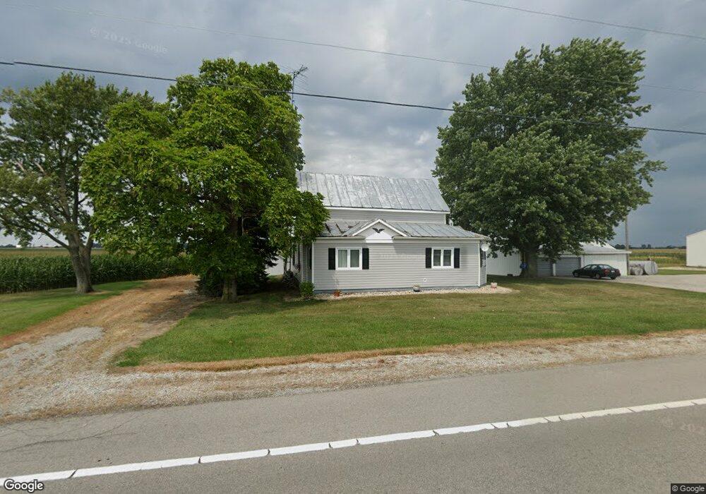
19581 State Route 67 Kenton, OH 43326
Estimated Value: $235,000
4
Beds
1
Bath
2,910
Sq Ft
$81/Sq Ft
Est. Value
About This Home
This home is located at 19581 State Route 67, Kenton, OH 43326 and is currently estimated at $235,000, approximately $80 per square foot. 19581 State Route 67 is a home located in Hardin County with nearby schools including Kenton Elementary School, Kenton Middle School, and Kenton High School.
Ownership History
Date
Name
Owned For
Owner Type
Purchase Details
Closed on
Nov 2, 2023
Sold by
Mccullough Terri
Bought by
Stephen M And Terri L Mccullough Family Trust and Gorman
Current Estimated Value
Purchase Details
Closed on
May 4, 2021
Sold by
Mccullough Dustin and Miller Morgan Latham
Bought by
Mccullough Terri and Latham Tirey
Purchase Details
Closed on
May 3, 2021
Sold by
Mccullough Terri and Latham Tirey
Bought by
Latham Lewis
Purchase Details
Closed on
Jan 7, 2021
Sold by
Estate Of Lewis E Latham
Bought by
Mccullough Terri and Latham Tirey
Create a Home Valuation Report for This Property
The Home Valuation Report is an in-depth analysis detailing your home's value as well as a comparison with similar homes in the area
Home Values in the Area
Average Home Value in this Area
Purchase History
| Date | Buyer | Sale Price | Title Company |
|---|---|---|---|
| Stephen M And Terri L Mccullough Family Trust | -- | None Listed On Document | |
| Mccullough Terri | -- | None Available | |
| Latham Lewis | -- | None Available | |
| Mccullough Terri | -- | None Available |
Source: Public Records
Tax History Compared to Growth
Tax History
| Year | Tax Paid | Tax Assessment Tax Assessment Total Assessment is a certain percentage of the fair market value that is determined by local assessors to be the total taxable value of land and additions on the property. | Land | Improvement |
|---|---|---|---|---|
| 2024 | $1,572 | $28,120 | $28,120 | $0 |
| 2023 | $1,246 | $28,120 | $28,120 | $0 |
| 2022 | $702 | $15,100 | $15,100 | $0 |
| 2021 | $296 | $64,630 | $20,300 | $44,330 |
| 2020 | $2,302 | $64,630 | $20,300 | $44,330 |
| 2019 | $2,299 | $67,060 | $30,290 | $36,770 |
| 2018 | $2,302 | $67,060 | $30,290 | $36,770 |
| 2017 | $2,265 | $67,060 | $30,290 | $36,770 |
| 2016 | $1,995 | $62,740 | $37,360 | $25,380 |
| 2015 | $2,289 | $62,740 | $37,360 | $25,380 |
| 2014 | $1,991 | $62,740 | $37,360 | $25,380 |
| 2013 | $1,368 | $43,610 | $18,230 | $25,380 |
Source: Public Records
Map
Nearby Homes
- 18322 State Route 67
- 21109 State Route 67
- 10483 Township Road 225
- 16877 State Route 67
- 23385 Township Road 126
- 12535 Barbara Dr
- 12126 Pamela Dr
- 12160 Pamela Dr
- 0 Ohio 309
- 13965 County Road 209
- 9960 State Route 53
- 0 Township Road 64
- 125 Hester St
- 777 Maydoll Dr
- 460 Oriental St
- 79 Broadway St
- 5091 County Road 175
- 618 N High St
- 115 Scioto St
- 530 E Franklin St
- 19638 State Route 67
- 19341 State Route 67
- 19341 State Route 67
- 19320 State Route 67
- 19320 State Route 67
- 9556 Township Rd
- 9556 Township Road 209
- 8949 County Road 215
- 8857 County Road 215
- 20195 County Road 100
- 19121 State Route 67
- 20195 County Rd
- 9087 County Road 205
- 8890 County Road 205
- 9626 Township Road 215
- 000 Twp Road 205
- 18937 Township Road 100
- 9387 County Road 205
- 20270 State Route 67