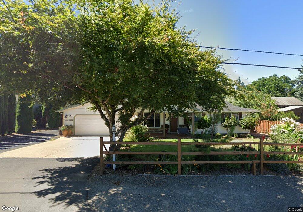
19593 S Mccord Rd Oregon City, OR 97045
Estimated Value: $560,000 - $650,000
3
Beds
2
Baths
984
Sq Ft
$622/Sq Ft
Est. Value
About This Home
This home is located at 19593 S Mccord Rd, Oregon City, OR 97045 and is currently estimated at $612,238, approximately $622 per square foot. 19593 S Mccord Rd is a home located in Clackamas County with nearby schools including John McLoughlin Elementary School, Gardiner Middle School, and Oregon City Senior High School.
Ownership History
Date
Name
Owned For
Owner Type
Purchase Details
Closed on
Dec 8, 2005
Sold by
Dotson Rick C
Bought by
Smith Garrett P and Smith Leigh N
Current Estimated Value
Home Financials for this Owner
Home Financials are based on the most recent Mortgage that was taken out on this home.
Original Mortgage
$120,000
Outstanding Balance
$66,541
Interest Rate
6.14%
Mortgage Type
Fannie Mae Freddie Mac
Estimated Equity
$545,697
Purchase Details
Closed on
Apr 27, 2005
Sold by
Moffatt Timothy O and Moffatt Jan Marie
Bought by
Dotson Rick C and Smith Garrett Paul
Create a Home Valuation Report for This Property
The Home Valuation Report is an in-depth analysis detailing your home's value as well as a comparison with similar homes in the area
Home Values in the Area
Average Home Value in this Area
Purchase History
| Date | Buyer | Sale Price | Title Company |
|---|---|---|---|
| Smith Garrett P | -- | Pacific Nw Title | |
| Dotson Rick C | $177,950 | Pacific Nw Title |
Source: Public Records
Mortgage History
| Date | Status | Borrower | Loan Amount |
|---|---|---|---|
| Open | Smith Garrett P | $120,000 |
Source: Public Records
Tax History Compared to Growth
Tax History
| Year | Tax Paid | Tax Assessment Tax Assessment Total Assessment is a certain percentage of the fair market value that is determined by local assessors to be the total taxable value of land and additions on the property. | Land | Improvement |
|---|---|---|---|---|
| 2024 | $4,488 | $287,663 | -- | -- |
| 2023 | $4,488 | $279,285 | $0 | $0 |
| 2022 | $4,109 | $271,151 | $0 | $0 |
| 2021 | $3,935 | $263,254 | $0 | $0 |
| 2020 | $3,823 | $255,587 | $0 | $0 |
| 2019 | $3,748 | $248,143 | $0 | $0 |
| 2018 | $3,546 | $240,916 | $0 | $0 |
| 2017 | $3,456 | $233,899 | $0 | $0 |
| 2016 | $3,380 | $227,086 | $0 | $0 |
| 2015 | $3,293 | $220,472 | $0 | $0 |
| 2014 | $3,200 | $214,050 | $0 | $0 |
Source: Public Records
Map
Nearby Homes
- 19693 Leland Rd
- 19327 Reddaway Ave
- 12618 Villard Place
- 12795 Lindsay Anne Ln
- 19457 Sunset Springs Dr
- 19326 Silverfox Pkwy
- 19144 Gentry Highlands Ln
- 19108 Sunrise Way
- 19338 Inishbride Ct
- 19903 Leland Rd
- 19537 Morrie Dr
- 19370 Westwood Dr
- 12288 Meadowlawn Dr
- 12270 Meadowlawn Dr
- 12252 Meadowlawn Dr
- 12246 Meadowlawn Dr
- 19390 Westwood Dr
- 19451 Prairie View Terrace
- 18940 Allegheny Dr
- 19474 Wild Bill Ct
- 19593 Mccord Rd
- 19613 Mccord Rd
- 19613 S Mccord Rd
- 19595 Mccord Rd
- 19585 Mccord Rd
- 19629 Mccord Rd
- 19578 S Mccord Rd
- 19578 S Mccord Rd Unit L131
- 19570 S Mccord Rd Unit L108
- 19562 S Mccord Rd Unit L107
- 19573 Mccord Rd
- 12777 Anita Place Unit L109
- 12785 Anita Place Unit L130
- 12769 Anita Place Unit L110
- 12761 Anita Place
- 19630 Mccord Rd
- 12753 Anita Place
- 19657 Mccord Rd
- 19657 S Mccord Rd
- 12768 Anita Place Unit L111