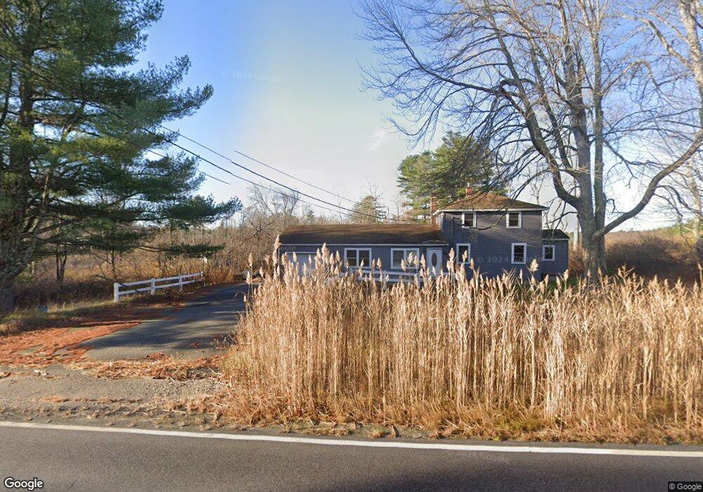
196 Bonny Eagle Rd Hollis Center, ME 04042
Hollis NeighborhoodEstimated Value: $366,881 - $494,000
4
Beds
2
Baths
1,750
Sq Ft
$250/Sq Ft
Est. Value
About This Home
This home is located at 196 Bonny Eagle Rd, Hollis Center, ME 04042 and is currently estimated at $437,720, approximately $250 per square foot. 196 Bonny Eagle Rd is a home located in York County with nearby schools including Bonny Eagle High School.
Ownership History
Date
Name
Owned For
Owner Type
Purchase Details
Closed on
Aug 24, 2005
Sold by
Shepard Vickie L
Bought by
Byrnes Daniel L
Current Estimated Value
Home Financials for this Owner
Home Financials are based on the most recent Mortgage that was taken out on this home.
Original Mortgage
$94,000
Interest Rate
5.68%
Mortgage Type
Unknown
Create a Home Valuation Report for This Property
The Home Valuation Report is an in-depth analysis detailing your home's value as well as a comparison with similar homes in the area
Home Values in the Area
Average Home Value in this Area
Purchase History
| Date | Buyer | Sale Price | Title Company |
|---|---|---|---|
| Byrnes Daniel L | -- | -- |
Source: Public Records
Mortgage History
| Date | Status | Borrower | Loan Amount |
|---|---|---|---|
| Closed | Byrnes Daniel L | $94,000 |
Source: Public Records
Tax History Compared to Growth
Tax History
| Year | Tax Paid | Tax Assessment Tax Assessment Total Assessment is a certain percentage of the fair market value that is determined by local assessors to be the total taxable value of land and additions on the property. | Land | Improvement |
|---|---|---|---|---|
| 2024 | $2,299 | $153,260 | $59,400 | $93,860 |
| 2023 | $2,222 | $153,260 | $59,400 | $93,860 |
| 2022 | $2,299 | $153,260 | $59,400 | $93,860 |
| 2021 | $2,184 | $153,260 | $59,400 | $93,860 |
| 2020 | $2,146 | $153,260 | $59,400 | $93,860 |
| 2019 | $2,107 | $153,260 | $59,400 | $93,860 |
| 2018 | $2,013 | $151,930 | $58,070 | $93,860 |
| 2017 | $1,899 | $151,930 | $58,070 | $93,860 |
| 2016 | $1,816 | $151,930 | $58,070 | $93,860 |
| 2015 | $1,816 | $151,930 | $58,070 | $93,860 |
| 2014 | $1,747 | $151,930 | $58,070 | $93,860 |
| 2013 | $1,671 | $151,930 | $58,070 | $93,860 |
Source: Public Records
Map
Nearby Homes
- 12 White Pine Dr
- 135 Bonny Eagle Rd
- 7 Pelletier Dr
- 5 Pelletier Dr
- Lot 10 Pelletier Dr
- Lot 8 Pelletier Dr
- 4 Pelletier Dr
- 2 Bonny Eagle Rd
- 20 River Rd
- 541 Cape Rd
- Lot 2 Commerce Way
- 280 Plains Rd
- 45 Quail Trail
- 580 Bonny Eagle Rd
- 189 Saco Rd
- 57 Landry Dr
- 62 Emery Cir
- 44 Gilman Rd
- 103 Hardscrabble Rd
- 170 Dow Rd
- 0000 Bonny Eagle Rd
- 11 Hemlock Cove Rd
- 3 Hemlock Cove Rd
- 167 Bonny Eagle Rd
- 175 Bonny Eagle Rd
- 166 Bonny Eagle Rd
- 201 Bonny Eagle Rd
- 10 Hemlock Cove Rd
- 0 Hemlock Cove Rd
- 20 Hemlock Cove Rd
- 232 Bonny Eagle Rd
- 0 Spruce Ln
- 25 Hemlock Cove Rd
- 233 Bonny Eagle Rd
- 0 White Pine Dr Unit 743043
- 0 White Pine Dr Unit 443397
- 0 White Pine Dr Unit 1224808
- 0 White Pine Dr Unit 1096218
- Lot 8 Swanton Dr
- 27 Spruce Ln