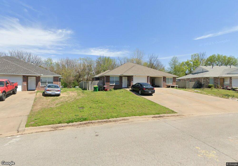
196 Killdeer Dr Farmington, AR 72730
Estimated Value: $336,000 - $400,000
Studio
4
Baths
2,344
Sq Ft
$156/Sq Ft
Est. Value
About This Home
This home is located at 196 Killdeer Dr, Farmington, AR 72730 and is currently estimated at $365,435, approximately $155 per square foot. 196 Killdeer Dr is a home located in Washington County with nearby schools including Randall G. Lynch Middle School, Bob Folsom Elementary School, and Farmington Jr. High.
Ownership History
Date
Name
Owned For
Owner Type
Purchase Details
Closed on
Nov 14, 2017
Sold by
Foster Kyle and Foster Midy
Bought by
Sparrow Hill Properties Llc
Current Estimated Value
Purchase Details
Closed on
Apr 8, 2016
Sold by
Bailey Marion C and Bailey Gina G
Bought by
Foster Kyle and Foster Mindy
Home Financials for this Owner
Home Financials are based on the most recent Mortgage that was taken out on this home.
Original Mortgage
$107,700
Interest Rate
3.62%
Mortgage Type
New Conventional
Purchase Details
Closed on
Nov 15, 1994
Bought by
Neal Bob and Neal Pam
Purchase Details
Closed on
Jan 1, 1994
Bought by
Horizons West Limited Ptnrshp
Create a Home Valuation Report for This Property
The Home Valuation Report is an in-depth analysis detailing your home's value as well as a comparison with similar homes in the area
Home Values in the Area
Average Home Value in this Area
Purchase History
| Date | Buyer | Sale Price | Title Company |
|---|---|---|---|
| Sparrow Hill Properties Llc | -- | None Available | |
| Foster Kyle | $143,600 | Waco Title Co | |
| Neal Bob | -- | -- | |
| Neal Terry | $75,000 | -- | |
| Horizons West Limited Ptnrshp | -- | -- |
Source: Public Records
Mortgage History
| Date | Status | Borrower | Loan Amount |
|---|---|---|---|
| Previous Owner | Foster Kyle | $107,700 |
Source: Public Records
Tax History
| Year | Tax Paid | Tax Assessment Tax Assessment Total Assessment is a certain percentage of the fair market value that is determined by local assessors to be the total taxable value of land and additions on the property. | Land | Improvement |
|---|---|---|---|---|
| 2025 | $2,377 | $55,810 | $8,550 | $47,260 |
| 2024 | $2,216 | $55,810 | $8,550 | $47,260 |
| 2023 | $2,118 | $55,810 | $8,550 | $47,260 |
| 2022 | $1,926 | $35,930 | $6,000 | $29,930 |
| 2021 | $1,857 | $35,930 | $6,000 | $29,930 |
| 2020 | $1,703 | $35,930 | $6,000 | $29,930 |
| 2019 | $1,541 | $28,490 | $6,000 | $22,490 |
| 2018 | $1,541 | $28,490 | $6,000 | $22,490 |
| 2017 | $1,527 | $28,490 | $6,000 | $22,490 |
| 2016 | $1,527 | $28,490 | $6,000 | $22,490 |
| 2015 | $1,527 | $28,490 | $6,000 | $22,490 |
| 2014 | $1,585 | $29,570 | $6,000 | $23,570 |
Source: Public Records
Map
Nearby Homes
- 75 & 81 W Dakota Trail
- 124 Signature Dr
- 265 Greenfield Ave
- 264 Sundown Dr
- 271 Greenfield Ave
- 201 Countryside Dr
- 46 Briarmeadow St
- 334 W Tyler Rd
- 335 W Tyler Rd
- 258 S Amber Dawn Ave
- 249 Wedgeview Dr
- 265 S Amber Dawn Ave
- 114 W Main St
- 180 W Main St
- 3480 Red Tail Way
- 9 Locust St
- TBD White St
- 0 W Main St Unit 1281343
- 0 W Main St Unit 1.2 AC
- 0 W Main St Unit 1291778
- 192 Killdeer Dr
- 190 & 192 Killdeer Dr
- 202 Killdeer Dr
- 190 Killdeer Dr
- 190 Killdeer Dr Unit 2
- 190 Killdeer Dr
- 208 Killdeer Dr
- 184 Killdeer Dr
- 184 Killdeer Dr Unit 184-186
- 207 Killdeer Dr
- 144 W Rainsong St
- 144 Rainsong Dr
- 178 Killdeer Dr
- 178 Killdeer Dr Unit 2
- 180 Killdeer Dr
- 215 Killdeer Dr
- 181 Killdeer Dr
- 1901 Killdeer Dr
- 169 & 171 W Plover Cove
- 169 Plover Cove
Your Personal Tour Guide
Ask me questions while you tour the home.