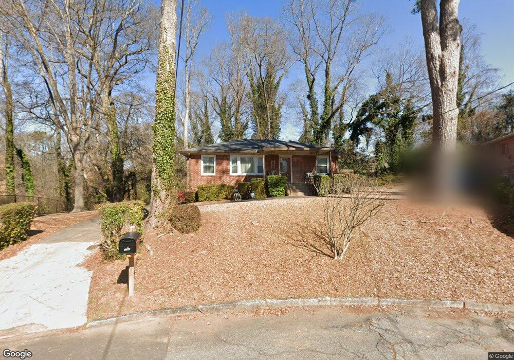
196 Napoleon Dr SW Atlanta, GA 30314
West End NeighborhoodEstimated Value: $212,000 - $446,000
2
Beds
1
Bath
1,242
Sq Ft
$230/Sq Ft
Est. Value
About This Home
This home is located at 196 Napoleon Dr SW, Atlanta, GA 30314 and is currently estimated at $285,163, approximately $229 per square foot. 196 Napoleon Dr SW is a home located in Fulton County with nearby schools including M. A. Jones Elementary School, Herman J. Russell West End Academy, and Booker T. Washington High School.
Ownership History
Date
Name
Owned For
Owner Type
Purchase Details
Closed on
Jun 30, 2006
Sold by
Rutledge Pinky A
Bought by
Rutledge Samuel A and Rutledge Pinky A
Current Estimated Value
Home Financials for this Owner
Home Financials are based on the most recent Mortgage that was taken out on this home.
Original Mortgage
$100,000
Outstanding Balance
$38,675
Interest Rate
6.6%
Mortgage Type
New Conventional
Estimated Equity
$246,488
Create a Home Valuation Report for This Property
The Home Valuation Report is an in-depth analysis detailing your home's value as well as a comparison with similar homes in the area
Home Values in the Area
Average Home Value in this Area
Purchase History
| Date | Buyer | Sale Price | Title Company |
|---|---|---|---|
| Rutledge Samuel A | -- | -- |
Source: Public Records
Mortgage History
| Date | Status | Borrower | Loan Amount |
|---|---|---|---|
| Open | Rutledge Samuel A | $100,000 |
Source: Public Records
Tax History Compared to Growth
Tax History
| Year | Tax Paid | Tax Assessment Tax Assessment Total Assessment is a certain percentage of the fair market value that is determined by local assessors to be the total taxable value of land and additions on the property. | Land | Improvement |
|---|---|---|---|---|
| 2025 | $1,087 | $93,600 | $46,000 | $47,600 |
| 2023 | $5,576 | $134,680 | $92,920 | $41,760 |
| 2022 | $1,294 | $96,040 | $53,760 | $42,280 |
| 2021 | $546 | $63,000 | $37,360 | $25,640 |
| 2020 | $415 | $42,160 | $27,680 | $14,480 |
| 2019 | $436 | $41,440 | $27,200 | $14,240 |
| 2018 | $33 | $15,720 | $6,440 | $9,280 |
| 2017 | $26 | $15,120 | $6,200 | $8,920 |
| 2016 | $27 | $15,120 | $6,200 | $8,920 |
| 2015 | $349 | $15,120 | $6,200 | $8,920 |
| 2014 | $25 | $15,120 | $6,200 | $8,920 |
Source: Public Records
Map
Nearby Homes
- 1165 Fair St SW
- 1159 Fair St SW
- 136 Stafford St SW
- 1261 Calhoun Terrace SW
- 1150 Fair St SW
- 253 1st St SW
- 1309 Fair St SW
- 167 Rockmart Dr SW
- 151 Rockmart Dr SW
- 230 Rosser St SW
- 0 Rockmart Dr SW Unit 10617090
- 1298 Gideons Dr SW
- 253 Lawton St SW
- 91 Morris Brown Dr SW
- 1270 M l King jr Dr SW
- 1322 Thurgood St SW
- 1193 M l King jr Dr SW
- 375 Atwood St SW
- 1022 Ashby Grove SW
- 202 Napoleon Dr SW
- 189 Holderness St SW
- 197 Holderness St SW
- 206 Napoleon Dr SW
- 181 Holderness St SW
- 181 Holderness St SW Unit 181 &183
- 205 Holderness St SW
- 1239 Fair St SW
- 175 Holderness St SW
- 209 Holderness St SW
- 214 Napoleon Dr SW
- 177 Holderness St SW
- 169 Holderness St SW
- 215 Holderness St SW
- 207 Napoleon Dr SW
- 194 Burbank Dr SW
- 163 Holderness St SW
- 220 Napoleon Dr SW
- 188 Burbank Dr SW
- 1179 Fair St SW