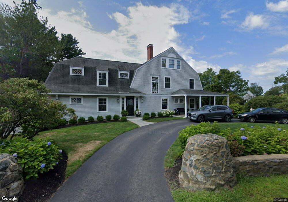
196 Whipple Rd Kittery, ME 03904
Estimated Value: $1,477,000 - $2,271,000
3
Beds
4
Baths
3,953
Sq Ft
$468/Sq Ft
Est. Value
About This Home
This home is located at 196 Whipple Rd, Kittery, ME 03904 and is currently estimated at $1,850,436, approximately $468 per square foot. 196 Whipple Rd is a home with nearby schools including Horace Mitchell Primary School, Shapleigh School, and Robert W Traip Academy.
Ownership History
Date
Name
Owned For
Owner Type
Purchase Details
Closed on
Mar 10, 2023
Sold by
Barnhorst Cathy G
Bought by
Barnhorst Ft
Current Estimated Value
Purchase Details
Closed on
Jul 20, 2021
Sold by
Barnhorst Cathy G
Bought by
Forbes Taylor T
Purchase Details
Closed on
Apr 24, 2009
Sold by
Barnhorst Stephen J
Bought by
Barnhorst Cathy G
Purchase Details
Closed on
Sep 27, 2006
Sold by
Beierl Peter G
Bought by
Beierl Frances E and Beierl Peter G
Create a Home Valuation Report for This Property
The Home Valuation Report is an in-depth analysis detailing your home's value as well as a comparison with similar homes in the area
Home Values in the Area
Average Home Value in this Area
Purchase History
| Date | Buyer | Sale Price | Title Company |
|---|---|---|---|
| Barnhorst Ft | -- | None Available | |
| Forbes Taylor T | -- | None Available | |
| Barnhorst Cathy G | -- | -- | |
| Beierl Frances E | -- | -- |
Source: Public Records
Mortgage History
| Date | Status | Borrower | Loan Amount |
|---|---|---|---|
| Previous Owner | Barnhorst Cathy G | $350,000 | |
| Previous Owner | Barnhorst Cathy G | $250,000 |
Source: Public Records
Tax History
| Year | Tax Paid | Tax Assessment Tax Assessment Total Assessment is a certain percentage of the fair market value that is determined by local assessors to be the total taxable value of land and additions on the property. | Land | Improvement |
|---|---|---|---|---|
| 2024 | $17,324 | $1,220,000 | $671,800 | $548,200 |
| 2023 | $16,604 | $1,220,000 | $671,800 | $548,200 |
| 2022 | $16,070 | $1,192,100 | $671,800 | $520,300 |
| 2021 | $15,578 | $1,198,300 | $678,000 | $520,300 |
| 2020 | $15,458 | $1,198,300 | $678,000 | $520,300 |
| 2019 | $16,981 | $975,900 | $549,100 | $426,800 |
| 2018 | $16,395 | $975,900 | $549,100 | $426,800 |
| 2017 | $15,454 | $936,600 | $549,100 | $387,500 |
| 2016 | $15,032 | $936,600 | $549,100 | $387,500 |
| 2015 | $14,677 | $936,600 | $549,100 | $387,500 |
| 2014 | $14,536 | $936,600 | $549,100 | $387,500 |
| 2013 | $14,255 | $936,600 | $549,100 | $387,500 |
Source: Public Records
Map
Nearby Homes
- 12 Gillis Dr Unit 3
- 4 Trefethen Ave
- 24 Seabreeze Ln
- 8 Spruce Point Rd
- 18 Mainmast Cir
- 100 Shepard's Cove Rd Unit H305
- 100 Shepard's Cove Rd Unit G107
- 100 Shepards Cove Rd Unit F204
- 100 Shepards Cove Rd Unit H301
- 25 S Mill St
- 36 State St
- 35 Badgers Island W Unit 203
- 35 Badgers Island W Unit 301
- 35 Badgers Island W Unit 302
- 35 Badgers Island W Unit 103
- 30-3 Regency Cir Unit 3
- 66 State St Unit 202
- 20 Mendum Ave
- 80 State St Unit 302
- 137 Daniel St Unit D302
Your Personal Tour Guide
Ask me questions while you tour the home.