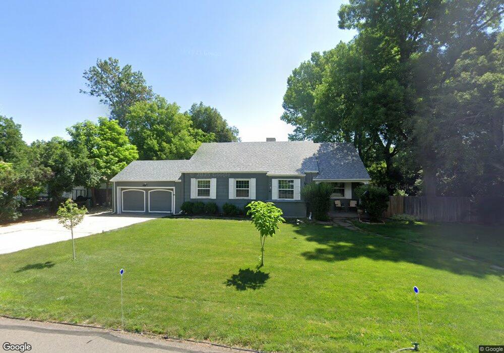
1960 Glen Dale Dr Lakewood, CO 80215
Morse Park NeighborhoodEstimated Value: $685,000 - $1,120,000
3
Beds
3
Baths
3,283
Sq Ft
$266/Sq Ft
Est. Value
About This Home
This home is located at 1960 Glen Dale Dr, Lakewood, CO 80215 and is currently estimated at $874,603, approximately $266 per square foot. 1960 Glen Dale Dr is a home located in Jefferson County with nearby schools including Slater Elementary School, Lakewood High School, and Our Lady Of Fatima Catholic School.
Ownership History
Date
Name
Owned For
Owner Type
Purchase Details
Closed on
Jan 25, 2023
Sold by
Lundgren Alexis K
Bought by
Gold Jacqueline M and Glenn James H
Current Estimated Value
Home Financials for this Owner
Home Financials are based on the most recent Mortgage that was taken out on this home.
Original Mortgage
$584,250
Outstanding Balance
$565,719
Interest Rate
6.27%
Mortgage Type
New Conventional
Estimated Equity
$308,884
Purchase Details
Closed on
Oct 27, 2017
Sold by
Lenhart Lori Rosella
Bought by
Lundgren Alexis K
Home Financials for this Owner
Home Financials are based on the most recent Mortgage that was taken out on this home.
Original Mortgage
$600,000
Interest Rate
3.83%
Mortgage Type
Purchase Money Mortgage
Purchase Details
Closed on
Nov 23, 1993
Sold by
Lenhart Harold F
Bought by
Lenhart Harold F and Lenhart Lori Rosella
Home Financials for this Owner
Home Financials are based on the most recent Mortgage that was taken out on this home.
Original Mortgage
$108,000
Interest Rate
6.71%
Create a Home Valuation Report for This Property
The Home Valuation Report is an in-depth analysis detailing your home's value as well as a comparison with similar homes in the area
Home Values in the Area
Average Home Value in this Area
Purchase History
| Date | Buyer | Sale Price | Title Company |
|---|---|---|---|
| Gold Jacqueline M | $615,000 | -- | |
| Lundgren Alexis K | $595,000 | Guardian Title | |
| Lenhart Harold F | -- | Land Title |
Source: Public Records
Mortgage History
| Date | Status | Borrower | Loan Amount |
|---|---|---|---|
| Open | Gold Jacqueline M | $584,250 | |
| Previous Owner | Lundgren Alexis K | $600,000 | |
| Previous Owner | Lenhart Harold F | $108,000 |
Source: Public Records
Tax History Compared to Growth
Tax History
| Year | Tax Paid | Tax Assessment Tax Assessment Total Assessment is a certain percentage of the fair market value that is determined by local assessors to be the total taxable value of land and additions on the property. | Land | Improvement |
|---|---|---|---|---|
| 2024 | $4,061 | $45,034 | $18,698 | $26,336 |
| 2023 | $4,061 | $45,034 | $18,698 | $26,336 |
| 2022 | $3,423 | $37,103 | $16,344 | $20,759 |
| 2021 | $3,472 | $38,170 | $16,814 | $21,356 |
| 2020 | $3,214 | $35,493 | $14,804 | $20,689 |
| 2019 | $3,172 | $35,493 | $14,804 | $20,689 |
| 2018 | $3,168 | $34,274 | $10,969 | $23,305 |
| 2017 | $2,784 | $34,274 | $10,969 | $23,305 |
| 2016 | $2,873 | $33,000 | $10,585 | $22,415 |
| 2015 | $2,447 | $33,000 | $10,585 | $22,415 |
| 2014 | $2,447 | $25,750 | $8,310 | $17,440 |
Source: Public Records
Map
Nearby Homes
- 1991 Glen Garry Dr
- 2295 Estes St
- 2060 Hoyt St
- 8211 Rocky Mountain Dr
- 2301 Brentwood St
- 2212 Ammons St
- 1600 Balsam St
- 1390 Everett Ct Unit 111
- 2580 Hoyt St
- 7800 W 20th Ave
- 9306 W 13th Place
- 1665 Yukon St
- 1690 Yukon St
- 2451 Kipling St Unit 214
- 2451 Kipling St Unit 201
- 7650 W 24th Ave
- 7625 W 23rd Place
- 1121 Carr St
- 9580 W 12th Place
- 1165 Independence St
- 1950 Glen Dale Dr
- 1980 Glen Dale Dr
- 1961 Glen Dale Dr
- 1951 Glen Dale Dr
- 1981 Glen Dale Dr
- 1990 Glen Dale Dr
- 8650 W 20th Ave
- 1930 Glen Dale Dr
- 1995 Glen Dale Dr
- 8640 W 20th Ave
- 1925 Dudley St
- 1935 Dudley St
- 1895 Glen Dale Dr
- 1970 Glen Garry Dr
- 1900 Glen Garry Dr
- 1980 Glen Garry Dr
- 1910 Glen Dale Dr
- 1915 Dudley St
- 1975 Dudley St
- 2005 Estes St