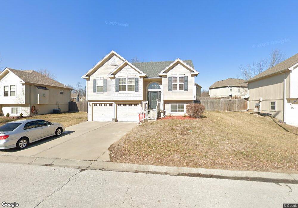
19616 E 10th St S Independence, MO 64056
Spring Branch NeighborhoodEstimated Value: $294,357 - $329,000
3
Beds
2
Baths
1,437
Sq Ft
$216/Sq Ft
Est. Value
About This Home
This home is located at 19616 E 10th St S, Independence, MO 64056 and is currently estimated at $310,089, approximately $215 per square foot. 19616 E 10th St S is a home located in Jackson County with nearby schools including Spring Branch Elementary School, Bridger Middle School, and Bingham Middle School.
Ownership History
Date
Name
Owned For
Owner Type
Purchase Details
Closed on
Aug 25, 2006
Sold by
Kevin Burke Construction Inc
Bought by
Bruce Anthony L and Bruce Nicole L
Current Estimated Value
Home Financials for this Owner
Home Financials are based on the most recent Mortgage that was taken out on this home.
Original Mortgage
$185,193
Outstanding Balance
$111,127
Interest Rate
6.75%
Mortgage Type
FHA
Estimated Equity
$198,962
Create a Home Valuation Report for This Property
The Home Valuation Report is an in-depth analysis detailing your home's value as well as a comparison with similar homes in the area
Home Values in the Area
Average Home Value in this Area
Purchase History
| Date | Buyer | Sale Price | Title Company |
|---|---|---|---|
| Bruce Anthony L | -- | Coffelt Land Title Inc |
Source: Public Records
Mortgage History
| Date | Status | Borrower | Loan Amount |
|---|---|---|---|
| Open | Bruce Anthony L | $185,193 |
Source: Public Records
Tax History
| Year | Tax Paid | Tax Assessment Tax Assessment Total Assessment is a certain percentage of the fair market value that is determined by local assessors to be the total taxable value of land and additions on the property. | Land | Improvement |
|---|---|---|---|---|
| 2025 | $3,353 | $53,270 | $3,950 | $49,320 |
| 2024 | $3,277 | $48,395 | $2,761 | $45,634 |
| 2023 | $3,277 | $48,395 | $4,786 | $43,609 |
| 2022 | $2,975 | $40,280 | $4,494 | $35,786 |
| 2021 | $2,974 | $40,280 | $4,494 | $35,786 |
| 2020 | $2,914 | $38,351 | $4,494 | $33,857 |
| 2019 | $2,868 | $38,351 | $4,494 | $33,857 |
| 2018 | $2,764 | $35,284 | $6,192 | $29,092 |
| 2017 | $2,764 | $35,284 | $6,192 | $29,092 |
| 2016 | $2,721 | $34,401 | $4,893 | $29,508 |
Source: Public Records
Map
Nearby Homes
- 933 S Kisner Dr
- 728 S Kisner Dr
- 907 S Jones Rd
- 20118 E Truman Rd
- 20108 E 12th Terrace S
- 20021 E 13th St S
- 1804 S Sioux Ct
- 801 S Butler Ln
- 701 S Jones Rd
- 18710 E Truman Rd
- 20602 E Truman Rd N
- 1904 S Davis Ave
- 20802 E 13th Terrace S
- 655 S Ranson St
- 1206 Ranson Place
- 20904 E 13th Terrace Ct S
- 21111 E 8th St S
- 20204 E 23rd Ter Ct S
- 2309 S Heartland Ct
- 1225 Berry Rd
- 19612 E 10th St S
- 939 Jones Ct
- 19620 E 10th St S
- 935 Jones Ct
- 936 Jones Ct
- 19608 E 10th St S
- 19621 E 10th St S
- 19617 E 10th St S
- 19613 E 10th St S
- 932 S Jones Ct
- 931 Jones Ct
- 932 Jones Ct
- 19604 E 10th St S
- 19609 E 10th St S
- 927 Jones Ct
- 928 Jones Ct
- 1109 S Alexander Rd
- 19600 E 10th St S
- 1103 S Alexander Rd
- 929 S Kisner Dr
Your Personal Tour Guide
Ask me questions while you tour the home.