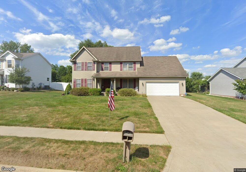
1962 Liberty Dr NE Louisville, OH 44641
Estimated Value: $296,000 - $328,000
3
Beds
3
Baths
1,974
Sq Ft
$159/Sq Ft
Est. Value
About This Home
This home is located at 1962 Liberty Dr NE, Louisville, OH 44641 and is currently estimated at $314,096, approximately $159 per square foot. 1962 Liberty Dr NE is a home located in Stark County with nearby schools including Louisville High School and St. Thomas Aquinas High School & Middle School.
Ownership History
Date
Name
Owned For
Owner Type
Purchase Details
Closed on
Nov 2, 2023
Sold by
Diener Frank J
Bought by
Frank J Diener Trust and Diener
Current Estimated Value
Purchase Details
Closed on
Aug 11, 2004
Sold by
Alpine Design & Development Corp
Bought by
Diener Frank J
Home Financials for this Owner
Home Financials are based on the most recent Mortgage that was taken out on this home.
Original Mortgage
$105,000
Interest Rate
6.1%
Mortgage Type
Purchase Money Mortgage
Purchase Details
Closed on
Dec 12, 2003
Sold by
C & M Development Inc
Bought by
Alpine Design & Development Corp
Home Financials for this Owner
Home Financials are based on the most recent Mortgage that was taken out on this home.
Original Mortgage
$1,610,000
Interest Rate
6.01%
Mortgage Type
Purchase Money Mortgage
Create a Home Valuation Report for This Property
The Home Valuation Report is an in-depth analysis detailing your home's value as well as a comparison with similar homes in the area
Home Values in the Area
Average Home Value in this Area
Purchase History
| Date | Buyer | Sale Price | Title Company |
|---|---|---|---|
| Frank J Diener Trust | -- | None Listed On Document | |
| Diener Frank J | $160,800 | -- | |
| Alpine Design & Development Corp | $1,610,000 | Land America/Lawyers Title |
Source: Public Records
Mortgage History
| Date | Status | Borrower | Loan Amount |
|---|---|---|---|
| Previous Owner | Diener Frank J | $105,000 | |
| Previous Owner | Alpine Design & Development Corp | $1,610,000 | |
| Closed | Diener Frank J | $20,000 |
Source: Public Records
Tax History Compared to Growth
Tax History
| Year | Tax Paid | Tax Assessment Tax Assessment Total Assessment is a certain percentage of the fair market value that is determined by local assessors to be the total taxable value of land and additions on the property. | Land | Improvement |
|---|---|---|---|---|
| 2025 | -- | $98,530 | $18,340 | $80,190 |
| 2024 | -- | $102,550 | $18,340 | $84,210 |
| 2023 | $2,851 | $66,360 | $14,070 | $52,290 |
| 2022 | $2,858 | $66,360 | $14,070 | $52,290 |
| 2021 | $2,866 | $66,360 | $14,070 | $52,290 |
| 2020 | $2,373 | $59,680 | $12,670 | $47,010 |
| 2019 | $2,383 | $59,680 | $12,670 | $47,010 |
| 2018 | $2,374 | $59,680 | $12,670 | $47,010 |
| 2017 | $1,996 | $48,410 | $8,160 | $40,250 |
| 2016 | $2,037 | $48,410 | $8,160 | $40,250 |
| 2015 | $2,003 | $47,470 | $8,160 | $39,310 |
| 2014 | $288 | $50,440 | $8,650 | $41,790 |
| 2013 | $1,148 | $50,440 | $8,650 | $41,790 |
Source: Public Records
Map
Nearby Homes
- 1639 Horizon Dr
- 1702 View Pointe Ave
- 908 Sand Lot Cir
- 822 Sand Lot Cir
- 6969 Georgetown St NE
- 510 S Bauman Ct
- 204 E Broad St
- 107 E Broad St
- 728 E Broad St
- 4060 Hambleton Ave NE
- 520 S Silver St
- 201 Indiana Ave
- 2425 Miday Ave NE
- 641 S Nickelplate St
- 8225 Georgetown St
- 248 Menegay Rd
- 6416 15th St NE
- 308 Superior St
- 325 Lincoln Ave
- 1715 High St
- 1972 Liberty Dr NE
- 1952 Liberty Dr NE
- 1942 Liberty Dr NE
- 1960 Pleasure Ct Unit 6
- 1966 Pleasure Ct Unit 5
- 1984 Liberty Dr NE
- 1950 Pleasure Ct Unit 8
- 1956 Pleasure Ct Unit 7
- 1944 Pleasure Ct Unit 9
- 1944 Pleasure Ct Unit 9
- 0 Pleasure Ct
- 715 Overlook St
- 1865 Vantage Dr
- 1932 Ravenna Ave
- 1914 Ravenna Ave
- 1971 Pleasure Ct Unit 14
- 1975 Pleasure Ct Unit 15
- 1855 Vantage Dr
- 1947 Pleasure Ct
- 1965 Pleasure Ct Unit 13