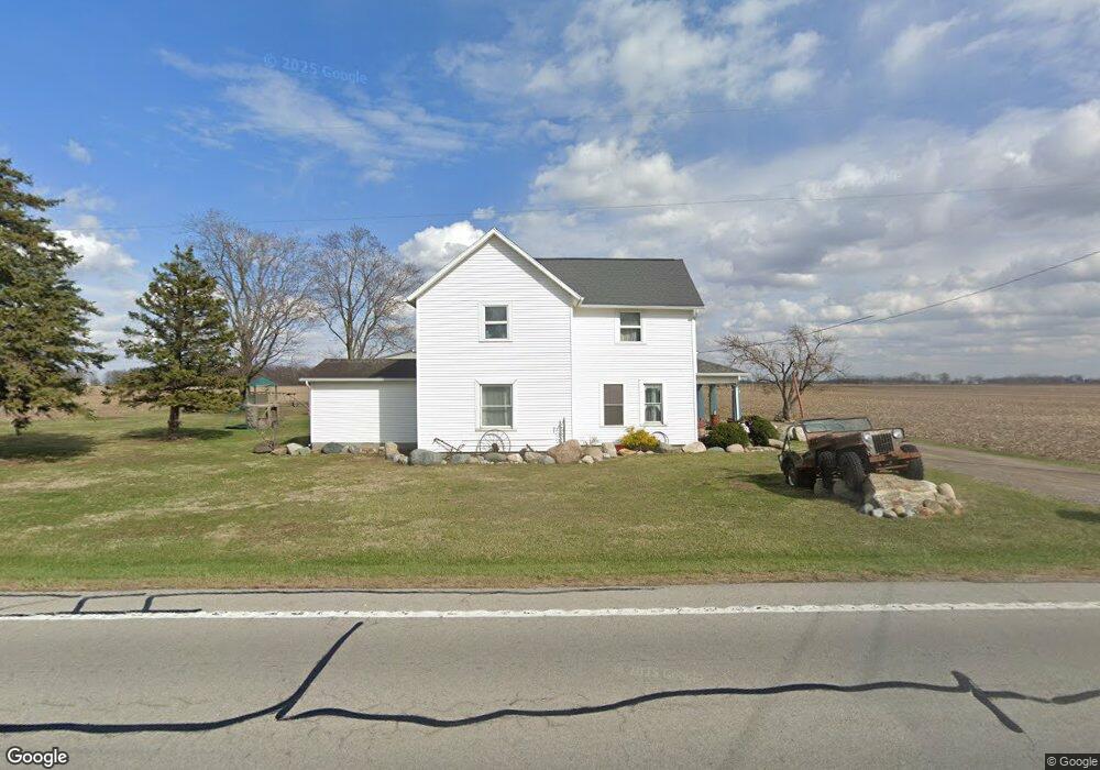
19635 State Route 115 Columbus Grove, OH 45830
Estimated Value: $249,000 - $301,000
4
Beds
2
Baths
2,134
Sq Ft
$128/Sq Ft
Est. Value
About This Home
This home is located at 19635 State Route 115, Columbus Grove, OH 45830 and is currently estimated at $272,261, approximately $127 per square foot. 19635 State Route 115 is a home located in Putnam County with nearby schools including Columbus Grove Elementary School, Columbus Grove Middle School, and Columbus Grove High School.
Ownership History
Date
Name
Owned For
Owner Type
Purchase Details
Closed on
Oct 9, 2017
Sold by
Rumble Reynold W and Rumble Carol M
Bought by
Meek Chase A and Meek Brittany C
Current Estimated Value
Home Financials for this Owner
Home Financials are based on the most recent Mortgage that was taken out on this home.
Original Mortgage
$157,203
Outstanding Balance
$132,794
Interest Rate
4.25%
Mortgage Type
FHA
Estimated Equity
$139,467
Purchase Details
Closed on
Nov 11, 2005
Sold by
Foust Earl A and Foust Marilyn A
Bought by
Rumble Reynald W and Rumble Carol M
Home Financials for this Owner
Home Financials are based on the most recent Mortgage that was taken out on this home.
Original Mortgage
$70,000
Interest Rate
6.2%
Mortgage Type
Future Advance Clause Open End Mortgage
Create a Home Valuation Report for This Property
The Home Valuation Report is an in-depth analysis detailing your home's value as well as a comparison with similar homes in the area
Home Values in the Area
Average Home Value in this Area
Purchase History
| Date | Buyer | Sale Price | Title Company |
|---|---|---|---|
| Meek Chase A | $160,500 | Attorney | |
| Rumble Reynald W | $105,000 | None Available |
Source: Public Records
Mortgage History
| Date | Status | Borrower | Loan Amount |
|---|---|---|---|
| Open | Meek Chase A | $157,203 | |
| Closed | Rumble Reynald W | $70,000 |
Source: Public Records
Tax History Compared to Growth
Tax History
| Year | Tax Paid | Tax Assessment Tax Assessment Total Assessment is a certain percentage of the fair market value that is determined by local assessors to be the total taxable value of land and additions on the property. | Land | Improvement |
|---|---|---|---|---|
| 2024 | $2,005 | $63,400 | $6,480 | $56,920 |
| 2023 | $2,051 | $46,540 | $5,040 | $41,500 |
| 2022 | $1,708 | $46,540 | $5,040 | $41,500 |
| 2021 | $1,747 | $46,540 | $5,040 | $41,500 |
| 2020 | $1,726 | $39,070 | $4,200 | $34,870 |
| 2019 | $1,521 | $42,000 | $5,040 | $36,960 |
| 2018 | $1,513 | $42,000 | $5,040 | $36,960 |
| 2017 | $1,379 | $42,000 | $5,040 | $36,960 |
| 2016 | $1,379 | $39,070 | $4,200 | $34,870 |
| 2015 | $1,386 | $39,070 | $4,200 | $34,870 |
| 2014 | $1,400 | $39,070 | $4,200 | $34,870 |
| 2013 | $1,423 | $39,070 | $4,200 | $34,870 |
Source: Public Records
Map
Nearby Homes
- 148 S Water St
- 147 Elm St
- 4150 W Lincoln Hwy
- 2525 W Lincoln Hwy
- 11059 Ottawa Rd
- 15105 Road 15m
- 308 Delphos Rd
- 209 Willow Bend Dr
- 205 S Broadway St
- 204 S Broadway St
- 6585 Ottawa Rd
- 300 Sweaney Ave
- 309 Wall St
- 201 Wall St
- 220 Parklane Dr
- 17736 Road 20p
- 3798 Kissing Hollow Dr
- 20501 U S 224
- 106 Carnation St
- 6585 Huffer Rd
- 19620 State Route 115
- 19728 State Route 115
- 19497 State Route 115
- 19829 Ohio 115
- 19829 State Route 115
- 19398 State Route 115
- 19514 State Route 115
- 19909 State Route 115
- 19909 St Route
- 20095 State Route 115
- 19189 State Route 115
- 19099 State Route 115
- 15378 Road S
- 18951 State Route 115
- 19673 Road 16s
- 19567 Road 16s
- 15234 Road S
- 256 Center St
- 19619 Road 16s
- 303B E Cross St