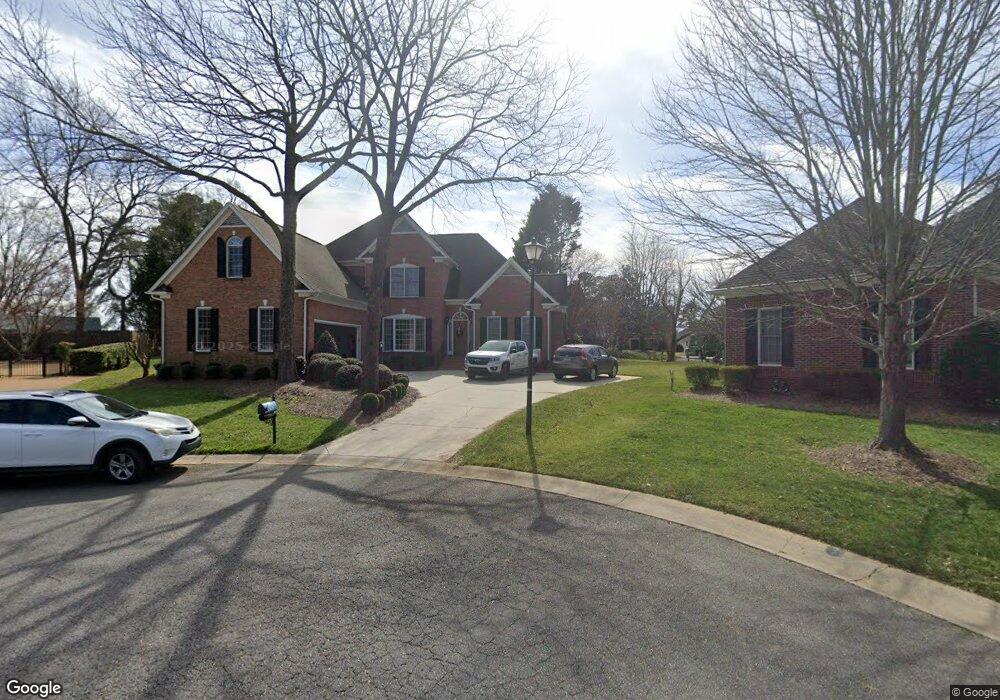
1964 Hammock Ln Rock Hill, SC 29732
Estimated Value: $462,938 - $538,000
3
Beds
3
Baths
2,829
Sq Ft
$182/Sq Ft
Est. Value
About This Home
This home is located at 1964 Hammock Ln, Rock Hill, SC 29732 and is currently estimated at $515,235, approximately $182 per square foot. 1964 Hammock Ln is a home located in York County with nearby schools including Ebinport Elementary School, W.C. Sullivan Middle School, and Rock Hill High School.
Ownership History
Date
Name
Owned For
Owner Type
Purchase Details
Closed on
Jun 26, 2013
Sold by
Parker Polly Caroline
Bought by
Strickland Robert A and Strickland Liza Lee
Current Estimated Value
Home Financials for this Owner
Home Financials are based on the most recent Mortgage that was taken out on this home.
Original Mortgage
$20,000
Outstanding Balance
$10,220
Interest Rate
4.39%
Mortgage Type
Credit Line Revolving
Estimated Equity
$500,767
Purchase Details
Closed on
May 26, 2011
Sold by
Parker G Alan and Parker Caroline P
Bought by
Parker Polly Caroline
Purchase Details
Closed on
Sep 16, 1999
Sold by
Malvern Group Llc
Bought by
Cw Collins Co Inc
Create a Home Valuation Report for This Property
The Home Valuation Report is an in-depth analysis detailing your home's value as well as a comparison with similar homes in the area
Home Values in the Area
Average Home Value in this Area
Purchase History
| Date | Buyer | Sale Price | Title Company |
|---|---|---|---|
| Strickland Robert A | $235,000 | -- | |
| Parker Polly Caroline | -- | -- | |
| Cw Collins Co Inc | $26,500 | -- |
Source: Public Records
Mortgage History
| Date | Status | Borrower | Loan Amount |
|---|---|---|---|
| Open | Strickland Robert A | $211,500 |
Source: Public Records
Tax History Compared to Growth
Tax History
| Year | Tax Paid | Tax Assessment Tax Assessment Total Assessment is a certain percentage of the fair market value that is determined by local assessors to be the total taxable value of land and additions on the property. | Land | Improvement |
|---|---|---|---|---|
| 2024 | $2,321 | $10,580 | $1,824 | $8,756 |
| 2023 | $2,328 | $10,580 | $1,824 | $8,756 |
| 2022 | $2,343 | $10,580 | $1,824 | $8,756 |
| 2021 | -- | $10,580 | $1,824 | $8,756 |
| 2020 | $2,349 | $10,580 | $0 | $0 |
| 2019 | $2,107 | $9,200 | $0 | $0 |
| 2018 | $2,104 | $9,200 | $0 | $0 |
| 2017 | $2,027 | $9,200 | $0 | $0 |
| 2016 | $2,008 | $9,200 | $0 | $0 |
| 2014 | $2,117 | $9,200 | $1,680 | $7,520 |
| 2013 | $2,117 | $13,800 | $2,520 | $11,280 |
Source: Public Records
Map
Nearby Homes
- 1981 Hamptonwood Rd
- 740 Tavern Ct Unit 7
- 2020 Malvern Rd
- 1780 Lumpkin Cir
- 606 Clouds Way
- 405 Jenny Skip Ln
- 2087 Poinsett Dr
- 2129 James Ct
- 358 Rose Garden Ct
- 651 Melville Dr
- 420 Bly St
- 1585 Kallaramo Rd
- 1631 Wendover Ct
- 448 Berryman Rd
- Garland Plan at Allston
- Gable Plan at Allston
- 310 Ginsberg Rd
- 306 Ginsberg Rd
- 302 Ginsberg Rd
- 854 Hillcroft Place
- 2043 Regency Ct
- 1977 Rosehaven Ln
- 1965 Hammock Ln
- 2085 Regency Ct
- 2021 Regency Ct
- 2145 Regency Ct
- 1993 Regency Ct
- 1959 Rosehaven Ln
- 1919 India Hook Rd
- 1919 India Hook Rd
- 1958 Middleton Place
- 2050 Regency Ct
- 1964 Middleton Place
- 1989 Rosehaven Ln
- 2161 Regency Ct
- 2120 Regency Ct
- 1976 Rosehaven Ln
- 1975 Regency Ct
- 1970 Rosehaven Ln
- 1972 Middleton Place