Estimated Value: $546,000 - $711,000
4
Beds
3
Baths
2,631
Sq Ft
$231/Sq Ft
Est. Value
About This Home
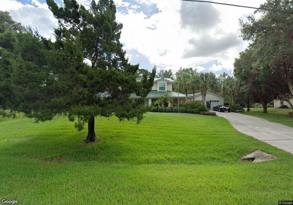
This home is located at 1965 Little Pine Ave, Cocoa, FL 32926 and is currently estimated at $608,672, approximately $231 per square foot. 1965 Little Pine Ave is a home located in Brevard County with nearby schools including Cocoa High School, Saturn Elementary School, and Space Coast Christian Academy.
Ownership History
Date
Name
Owned For
Owner Type
Purchase Details
Closed on
May 6, 2022
Sold by
Blankenship Michael D and Blankenship Patricia A
Bought by
Blankenship Family Revocable Trust
Current Estimated Value
Create a Home Valuation Report for This Property
The Home Valuation Report is an in-depth analysis detailing your home's value as well as a comparison with similar homes in the area
Home Values in the Area
Average Home Value in this Area
Purchase History
| Date | Buyer | Sale Price | Title Company |
|---|---|---|---|
| Blankenship Family Revocable Trust | -- | Winderweedle Haines Ward & Wo | |
| Blankenship Family Revocable Trust | $100 | None Listed On Document |
Source: Public Records
Tax History Compared to Growth
Tax History
| Year | Tax Paid | Tax Assessment Tax Assessment Total Assessment is a certain percentage of the fair market value that is determined by local assessors to be the total taxable value of land and additions on the property. | Land | Improvement |
|---|---|---|---|---|
| 2025 | $2,911 | $212,460 | -- | -- |
| 2024 | $2,805 | $206,480 | -- | -- |
| 2023 | $2,805 | $195,770 | $0 | $0 |
| 2022 | $2,630 | $190,070 | $0 | $0 |
| 2021 | $2,675 | $184,540 | $0 | $0 |
| 2020 | $2,584 | $182,000 | $0 | $0 |
| 2019 | $2,529 | $177,910 | $0 | $0 |
| 2018 | $2,531 | $174,600 | $0 | $0 |
| 2017 | $2,545 | $171,010 | $0 | $0 |
| 2016 | $2,579 | $167,500 | $40,600 | $126,900 |
| 2015 | $2,076 | $166,340 | $40,600 | $125,740 |
| 2014 | $2,082 | $165,020 | $31,900 | $133,120 |
Source: Public Records
Map
Nearby Homes
- 4900 Hidden Pine Place
- TBD Rayburn Rd
- 5011 Dalehurst Dr
- 1873 Longleaf Rd
- 2524 Trotters Trail
- 4630 James Rd
- 1325 Friday Rd
- 595 Outer Dr Unit 129
- 3816 Parapet Dr
- 2212 Spring Cir
- 634 Outer Dr
- 365 Outer Dr
- 494 Outer Dr
- 495 Outer Dr Unit 201
- 0 No Access (Titusville Fruit) Unit 1037909
- 000000 Unknown
- 00000 Unknown
- 336 Horseshoe Bend Cir Unit 197
- 436 Horseshoe Bend Cir Unit 192
- 755 Outer Dr Unit 362
- 1975 Little Pine Ave
- 1955 Little Pine Ave
- 1960 Little Pine Ave
- 1970 Little Pine Ave
- 1950 Little Pine Ave
- 1945 Little Pine Ave
- 1940 Little Pine Ave
- 4900 Pinewood Place
- 4910 Pinewood Place
- 1930 Little Pine Ave
- 4915 Pinewood Place
- 1920 Little Pine Ave
- 4920 Pinewood Place
- 4925 Pinewood Place
- 4912 Hidden Pine Place
- 4535 Rector Rd
- 1910 Little Pine Ave
- 4930 Pinewood Place
- 4924 Hidden Pine Place
- 4935 Pinewood Place