
Seller's Agent in 2025
Pete Reimer
Coldwell Banker Upchurch Realty
(706) 224-7840
1 in this area
25 Total Sales

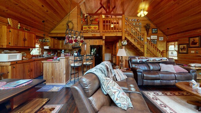


Welcome to 1969 Mauldin Rd, a beautifully built 3-bed, 3-bath log cabin nestled on over 11 private acres. This high-quality, custom-built home is constructed with durable Cypress logs, offering both lasting beauty and exceptional craftsmanship. Inside, enjoy an open layout with vaulted ceilings, rich wood finishes, and large windows that fill the space with natural light. The master suite features a private bath and generous closet space, with two additional bedrooms and baths for family or guests. Step outside to a full wraparound porch, perfect for relaxing in peaceful, natural surroundings. Downstairs includes a heated and cooled garage, a workshop area, and a separate man cave area-ideal for hobbies or entertaining. With room to roam, garden, or even bring your horses, this unique property is a rare find in Elberton. Schedule your showing today!
Last Agent to Sell the Property
Coldwell Banker Upchurch Realty License #432995 Listed on: 08/01/2025
| Date | Type | Sale Price | Title Company |
|---|---|---|---|
| Warranty Deed | $50,000 | -- |
| Date | Event | Price | List to Sale | Price per Sq Ft |
|---|---|---|---|---|
| 11/14/2025 11/14/25 | Sold | $520,000 | -2.8% | $143 / Sq Ft |
| 10/13/2025 10/13/25 | Pending | -- | -- | -- |
| 08/01/2025 08/01/25 | For Sale | $535,000 | -- | $147 / Sq Ft |
| Year | Tax Paid | Tax Assessment Tax Assessment Total Assessment is a certain percentage of the fair market value that is determined by local assessors to be the total taxable value of land and additions on the property. | Land | Improvement |
|---|---|---|---|---|
| 2024 | $4,365 | $187,375 | $27,174 | $160,201 |
| 2023 | $4,093 | $176,030 | $27,174 | $148,856 |
| 2022 | $3,341 | $144,598 | $23,362 | $121,236 |
| 2021 | $3,346 | $144,598 | $23,362 | $121,236 |
| 2020 | $3,075 | $118,424 | $18,690 | $99,734 |
| 2019 | $3,189 | $118,424 | $18,690 | $99,734 |
| 2018 | $3,282 | $118,424 | $18,690 | $99,734 |
| 2017 | $2,876 | $97,227 | $18,690 | $78,537 |
| 2016 | $2,695 | $97,227 | $18,690 | $78,537 |
| 2015 | -- | $97,227 | $18,690 | $78,537 |
| 2014 | -- | $97,227 | $18,690 | $78,537 |
| 2013 | -- | $97,227 | $18,690 | $78,537 |
Seller's Agent in 2025
Pete Reimer
Coldwell Banker Upchurch Realty
(706) 224-7840
1 in this area
25 Total Sales
Buyer's Agent in 2025
Jeremiah Peters
Virtual Properties Realty.com
(706) 410-8978
30 in this area
353 Total Sales
Source: Georgia MLS
MLS Number: 10576087
APN: 065-068F
Disclaimer: Certain information contained herein is derived from information provided by parties other than Homes.com. All information provided is deemed reliable, but is not guaranteed to be accurate and should be independently verified.
![]() The data relating to real estate for sale on this web site comes in part from the Broker Reciprocity Program of Georgia MLS. Real estate listings held by brokerage firms other than Redfin are marked with the Broker Reciprocity logo and detailed information about them includes the name of the listing brokers. Information deemed reliable but not guaranteed. Copyright 2025 Georgia MLS. All rights reserved.
The data relating to real estate for sale on this web site comes in part from the Broker Reciprocity Program of Georgia MLS. Real estate listings held by brokerage firms other than Redfin are marked with the Broker Reciprocity logo and detailed information about them includes the name of the listing brokers. Information deemed reliable but not guaranteed. Copyright 2025 Georgia MLS. All rights reserved.