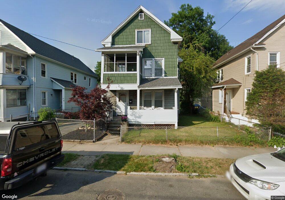
197 Commonwealth Ave Springfield, MA 01108
Forest Park NeighborhoodEstimated Value: $231,000 - $296,000
3
Beds
2
Baths
1,686
Sq Ft
$157/Sq Ft
Est. Value
About This Home
This home is located at 197 Commonwealth Ave, Springfield, MA 01108 and is currently estimated at $265,003, approximately $157 per square foot. 197 Commonwealth Ave is a home located in Hampden County with nearby schools including Alice B. Beal Elementary School, Forest Park Middle School, and High School Of Commerce.
Ownership History
Date
Name
Owned For
Owner Type
Purchase Details
Closed on
Nov 22, 1999
Sold by
Baez Jesus and Baez Damaris
Bought by
Department Of Housing & Urban Dev
Current Estimated Value
Purchase Details
Closed on
Dec 29, 1994
Sold by
Lawless Virginia M and Magnacca Anthony
Bought by
Baez Jesus and Baez Damaris
Home Financials for this Owner
Home Financials are based on the most recent Mortgage that was taken out on this home.
Original Mortgage
$50,460
Interest Rate
9.2%
Mortgage Type
Purchase Money Mortgage
Create a Home Valuation Report for This Property
The Home Valuation Report is an in-depth analysis detailing your home's value as well as a comparison with similar homes in the area
Home Values in the Area
Average Home Value in this Area
Purchase History
| Date | Buyer | Sale Price | Title Company |
|---|---|---|---|
| Department Of Housing & Urban Dev | $58,390 | -- | |
| Baez Jesus | $49,900 | -- |
Source: Public Records
Mortgage History
| Date | Status | Borrower | Loan Amount |
|---|---|---|---|
| Previous Owner | Baez Jesus | $50,460 |
Source: Public Records
Tax History
| Year | Tax Paid | Tax Assessment Tax Assessment Total Assessment is a certain percentage of the fair market value that is determined by local assessors to be the total taxable value of land and additions on the property. | Land | Improvement |
|---|---|---|---|---|
| 2025 | $3,249 | $207,200 | $36,800 | $170,400 |
| 2024 | $2,849 | $177,400 | $36,800 | $140,600 |
| 2023 | $2,839 | $166,500 | $35,100 | $131,400 |
| 2022 | $3,589 | $190,700 | $35,100 | $155,600 |
| 2021 | $3,030 | $160,300 | $31,900 | $128,400 |
| 2020 | $2,812 | $144,000 | $31,900 | $112,100 |
| 2019 | $2,478 | $125,900 | $31,900 | $94,000 |
| 2018 | $2,763 | $140,400 | $31,900 | $108,500 |
| 2017 | $2,505 | $127,400 | $31,900 | $95,500 |
| 2016 | $2,491 | $126,700 | $31,900 | $94,800 |
| 2015 | $2,425 | $123,300 | $31,900 | $91,400 |
Source: Public Records
Map
Nearby Homes
- 144 Washington St
- 44 Meredith St
- 570-572 Dickinson St
- 58 Appleton St
- 179 Carver St
- 69 Belvidere St
- 132 Carroll St
- 52 Orlando St
- 78 Whittier St
- 137 Carroll St
- 104 Appleton St
- 57 Lyndale St
- 147 Belvidere St
- 42 Carroll St
- 27 Ormond St
- 12 Carroll St
- 914-916 Belmont Ave
- 53 Texel Dr
- 52 Bremen St
- 43 Morningside Park
- 209 Commonwealth Ave
- 201 Commonwealth Ave Unit 203
- 193 Commonwealth Ave
- 207 Commonwealth Ave
- 207-209 Commonwealth Ave
- 38 Carver St Unit 40
- 187 Commonwealth Ave Unit 189
- 187 Commonwealth Ave Unit 1
- 42 Carver St Unit 44
- 32 Carver St Unit 34
- 38-40 Carver St
- 112 Fountain St Unit 114
- 24 Carver St Unit 26
- 24-26 Carver St
- 198 Commonwealth Ave Unit 200
- 211 Commonwealth Ave Unit 213
- 183 Commonwealth Ave
- 204 Commonwealth Ave
- 194 Commonwealth Ave
- 118 Fountain St Unit 120
Your Personal Tour Guide
Ask me questions while you tour the home.