Estimated Value: $587,193 - $629,000
4
Beds
4
Baths
2,645
Sq Ft
$228/Sq Ft
Est. Value
About This Home
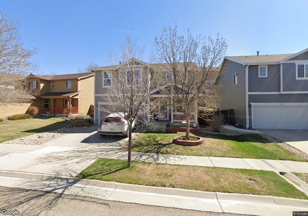
This home is located at 197 Mcafee Cir, Erie, CO 80516 and is currently estimated at $602,798, approximately $227 per square foot. 197 Mcafee Cir is a home located in Weld County with nearby schools including Red Hawk Elementary School, Erie Middle School, and Erie High School.
Ownership History
Date
Name
Owned For
Owner Type
Purchase Details
Closed on
Nov 22, 2017
Sold by
Jones Catherine
Bought by
Jones Catherine and Boogaard Corey Van De
Current Estimated Value
Purchase Details
Closed on
Feb 8, 2016
Sold by
Vande Boogaard Corey
Bought by
Jones Catherine
Purchase Details
Closed on
Mar 3, 2015
Sold by
Notman Lori L and Notman Brian L
Bought by
Corey Jones Catherine and Corey Van De Boogaard
Home Financials for this Owner
Home Financials are based on the most recent Mortgage that was taken out on this home.
Original Mortgage
$230,400
Interest Rate
3.68%
Mortgage Type
New Conventional
Purchase Details
Closed on
Mar 21, 2003
Sold by
Kb Home Colorado Inc
Bought by
Notman Brian L and Notman Lori L
Home Financials for this Owner
Home Financials are based on the most recent Mortgage that was taken out on this home.
Original Mortgage
$257,947
Interest Rate
5.8%
Mortgage Type
VA
Create a Home Valuation Report for This Property
The Home Valuation Report is an in-depth analysis detailing your home's value as well as a comparison with similar homes in the area
Home Values in the Area
Average Home Value in this Area
Purchase History
| Date | Buyer | Sale Price | Title Company |
|---|---|---|---|
| Jones Catherine | -- | None Available | |
| Jones Catherine | -- | None Available | |
| Corey Jones Catherine | $288,000 | Fidelity National Title Ins | |
| Notman Brian L | $265,813 | -- |
Source: Public Records
Mortgage History
| Date | Status | Borrower | Loan Amount |
|---|---|---|---|
| Previous Owner | Corey Jones Catherine | $230,400 | |
| Previous Owner | Notman Brian L | $257,947 |
Source: Public Records
Tax History Compared to Growth
Tax History
| Year | Tax Paid | Tax Assessment Tax Assessment Total Assessment is a certain percentage of the fair market value that is determined by local assessors to be the total taxable value of land and additions on the property. | Land | Improvement |
|---|---|---|---|---|
| 2025 | $3,485 | $35,360 | $7,880 | $27,480 |
| 2024 | $3,485 | $35,360 | $7,880 | $27,480 |
| 2023 | $3,360 | $36,630 | $7,850 | $28,780 |
| 2022 | $3,015 | $27,980 | $5,910 | $22,070 |
| 2021 | $3,079 | $28,780 | $6,080 | $22,700 |
| 2020 | $2,867 | $27,000 | $4,650 | $22,350 |
| 2019 | $2,894 | $27,000 | $4,650 | $22,350 |
| 2018 | $2,447 | $22,870 | $3,600 | $19,270 |
| 2017 | $2,378 | $22,870 | $3,600 | $19,270 |
| 2016 | $2,195 | $20,840 | $3,980 | $16,860 |
| 2015 | $2,129 | $20,840 | $3,980 | $16,860 |
| 2014 | $1,853 | $18,020 | $3,980 | $14,040 |
Source: Public Records
Map
Nearby Homes
- 560 Indian Peaks Dr
- 111 Ambrose St
- 30 Sun up Ct
- 61 Moonrise Ct
- 158 Summit Way
- 610 Sun up Place
- 173 Ambrose St
- 90 Pipit Lake Way
- 172 Painted Horse Way
- 360 Ambrose St
- 310 Ambrose St
- 390 Ambrose St
- 195 Briggs St
- 365 Briggs St
- 321 Pleades Place
- 420 Anderson St
- 410 Anderson St
- 190 Starlight Cir
- 37 Starlight Cir
- 626 Gallegos St