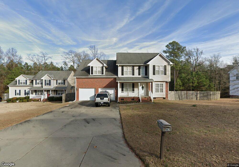
197 Rolling Stone (L240) Ct Sanford, NC 27332
Estimated Value: $307,095 - $325,000
3
Beds
3
Baths
2,174
Sq Ft
$145/Sq Ft
Est. Value
About This Home
This home is located at 197 Rolling Stone (L240) Ct, Sanford, NC 27332 and is currently estimated at $316,274, approximately $145 per square foot. 197 Rolling Stone (L240) Ct is a home located in Harnett County with nearby schools including Highland Elementary School, Highland Middle School, and Western Harnett High School.
Ownership History
Date
Name
Owned For
Owner Type
Purchase Details
Closed on
Nov 21, 2014
Sold by
Mines Jr Terry L and Mines Jessie D
Bought by
Mines Jr Terry L
Current Estimated Value
Home Financials for this Owner
Home Financials are based on the most recent Mortgage that was taken out on this home.
Original Mortgage
$178,850
Outstanding Balance
$137,459
Interest Rate
4.09%
Mortgage Type
VA
Estimated Equity
$178,815
Purchase Details
Closed on
Aug 19, 2008
Sold by
K&C Investment Properties Llc
Bought by
Mines Jr Terry L and Mines Jessie D
Home Financials for this Owner
Home Financials are based on the most recent Mortgage that was taken out on this home.
Original Mortgage
$190,509
Interest Rate
6.32%
Mortgage Type
VA
Create a Home Valuation Report for This Property
The Home Valuation Report is an in-depth analysis detailing your home's value as well as a comparison with similar homes in the area
Home Values in the Area
Average Home Value in this Area
Purchase History
| Date | Buyer | Sale Price | Title Company |
|---|---|---|---|
| Mines Jr Terry L | -- | None Available | |
| Mines Jr Terry L | $186,500 | -- |
Source: Public Records
Mortgage History
| Date | Status | Borrower | Loan Amount |
|---|---|---|---|
| Open | Mines Jr Terry L | $178,850 | |
| Closed | Mines Jr Terry L | $190,509 |
Source: Public Records
Tax History Compared to Growth
Tax History
| Year | Tax Paid | Tax Assessment Tax Assessment Total Assessment is a certain percentage of the fair market value that is determined by local assessors to be the total taxable value of land and additions on the property. | Land | Improvement |
|---|---|---|---|---|
| 2025 | $1,649 | $219,997 | $0 | $0 |
| 2024 | $1,649 | $219,997 | $0 | $0 |
| 2023 | $1,649 | $219,997 | $0 | $0 |
| 2022 | $1,659 | $219,997 | $0 | $0 |
| 2021 | $1,659 | $183,010 | $0 | $0 |
| 2020 | $1,641 | $183,010 | $0 | $0 |
| 2019 | $1,626 | $183,010 | $0 | $0 |
| 2018 | $1,607 | $183,010 | $0 | $0 |
| 2017 | $1,607 | $183,010 | $0 | $0 |
| 2016 | $1,678 | $191,470 | $0 | $0 |
| 2015 | $1,678 | $191,470 | $0 | $0 |
| 2014 | $1,678 | $191,470 | $0 | $0 |
Source: Public Records
Map
Nearby Homes
- 146 Rolling Stone Ct
- 642 Pinevalley Ln
- 515 Pinevalley Ln
- 50 Ridgeway Ct
- 305 Cresthaven Dr
- 351 Highland Forest Dr
- 71 Parkton Ct E
- 130 Blue Chip Ct
- 76 Lansing Ct W
- 119 Pinevalley Ln
- 20 Bluebird Ct
- 739 Nicole Dr
- 16 Lansing Ct E
- 144 Vail Ct
- 41 Andrea Ct
- 56 Timberline Dr
- 174 Silverthorne Dr
- 10 Boulder Dr
- 125 Tower Dr
- 197 Rolling Stone Ct
- 177 Rollingstone (L239) Ct
- 217 Rolling Stone Ct
- 217 Rolling Stone (L241) Ct
- 206 Rolling Stone (L210) Ct
- 206 Rolling Stone (L208) Ct
- 206 Rolling Stone Ct
- 157 Rolling Stone (L238) Ct
- 157 Rolling Stone Ct
- 242 Rolling Stone Ct
- 164 Rolling Stone Ct
- 228 Rolling Stone Ct
- 228 Rolling Stone (L209) Ct
- 235 Rolling Stone Ct
- 236 Rolling Stone Ct
- 624 Crystal Spring Dr
- 650 Crystal Spring Dr
- 604 Crystal Spring Dr
- 135 Rolling Stone Ct