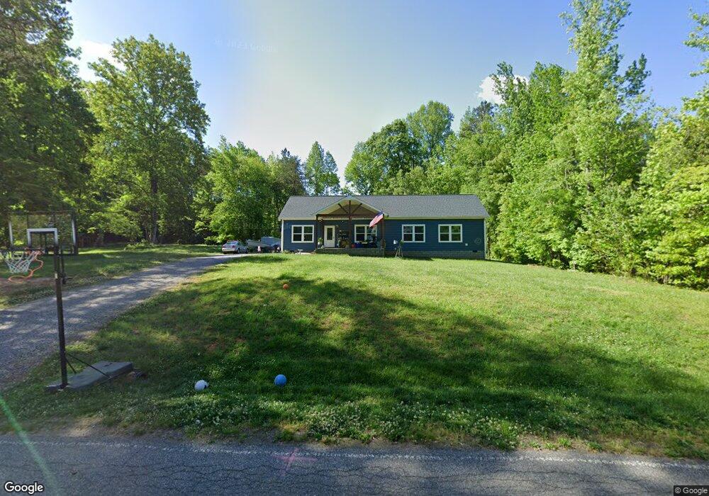
197 Shady Cove Rd Troutman, NC 28166
Estimated Value: $410,918 - $438,000
3
Beds
2
Baths
1,920
Sq Ft
$221/Sq Ft
Est. Value
About This Home
This home is located at 197 Shady Cove Rd, Troutman, NC 28166 and is currently estimated at $424,730, approximately $221 per square foot. 197 Shady Cove Rd is a home with nearby schools including Troutman Elementary School, Troutman Middle School, and South Iredell High School.
Ownership History
Date
Name
Owned For
Owner Type
Purchase Details
Closed on
Aug 31, 2018
Sold by
Murdock Flora L
Bought by
Welcher Hannah M and Welcher Robert F
Current Estimated Value
Purchase Details
Closed on
Dec 4, 2017
Sold by
Murdock Flora L
Bought by
Murdock Flora L
Purchase Details
Closed on
Dec 25, 2011
Purchase Details
Closed on
Oct 14, 1992
Purchase Details
Closed on
Jun 1, 1981
Create a Home Valuation Report for This Property
The Home Valuation Report is an in-depth analysis detailing your home's value as well as a comparison with similar homes in the area
Home Values in the Area
Average Home Value in this Area
Purchase History
| Date | Buyer | Sale Price | Title Company |
|---|---|---|---|
| Welcher Hannah M | -- | None Available | |
| Murdock Flora L | -- | None Available | |
| -- | -- | -- | |
| -- | -- | -- | |
| -- | -- | -- | |
| -- | -- | -- |
Source: Public Records
Tax History Compared to Growth
Tax History
| Year | Tax Paid | Tax Assessment Tax Assessment Total Assessment is a certain percentage of the fair market value that is determined by local assessors to be the total taxable value of land and additions on the property. | Land | Improvement |
|---|---|---|---|---|
| 2025 | $2,357 | $382,890 | $50,000 | $332,890 |
| 2024 | $2,357 | $382,890 | $50,000 | $332,890 |
| 2023 | $2,357 | $382,890 | $50,000 | $332,890 |
| 2022 | $1,683 | $254,520 | $45,000 | $209,520 |
| 2021 | $1,653 | $254,520 | $45,000 | $209,520 |
| 2020 | $1,653 | $254,520 | $45,000 | $209,520 |
| 2019 | $1,146 | $180,910 | $45,000 | $135,910 |
| 2018 | $269 | $45,000 | $45,000 | $0 |
| 2017 | $269 | $45,000 | $45,000 | $0 |
| 2016 | $269 | $45,000 | $45,000 | $0 |
| 2015 | $269 | $45,000 | $45,000 | $0 |
| 2014 | $248 | $45,000 | $45,000 | $0 |
Source: Public Records
Map
Nearby Homes
- 134 Millard Ln
- 110 Emmaline Ct
- 299 Hamptons Cove Rd
- 142 Rolling Meadows Dr
- 124 Bentley Ct Unit 6
- 143 Rolling Meadows Dr
- 110 Captains Way
- Fontana Plan at Rolling Meadows
- Pinehurst II Plan at Rolling Meadows
- Roanoke Plan at Rolling Meadows
- Davidson Plan at Rolling Meadows
- Avenel II Plan at Rolling Meadows
- Lexington II Plan at Rolling Meadows
- Charleston Plan at Rolling Meadows
- 552 Fern Hill Rd
- 510 Fern Hill Rd Unit 15
- 516 Fern Hill Rd
- 155 Streamwood Rd
- 172 Tennessee Cir
- 433 Lockhard Cir
- 203 Shady Cove Rd
- 185 Shady Cove Rd
- 196 Shady Cove Rd
- 156 Crooked Branch Way
- 156 Crooked Branch Way Unit 48
- 200 Shady Cove Rd
- 164 Crooked Branch Way
- 211 Shady Cove Rd
- 148 Crooked Branch Way
- 148 Crooked Branch Way Unit 49
- 181 Shady Cove Rd
- 0 Alfara Ln
- 215 Shady Cove Rd
- 168 Crooked Branch Way Unit 45
- 168 Crooked Branch Way
- 168 Crooked Branch Way Unit 46
- 150 Crooked Branch Unit 50
- 145 Crooked Branch Unit 34
- 140 Crooked Branch Way
- 140 Crooked Branch Way Unit 50