Estimated Value: $539,174 - $738,000
6
Beds
4
Baths
6,449
Sq Ft
$94/Sq Ft
Est. Value
About This Home
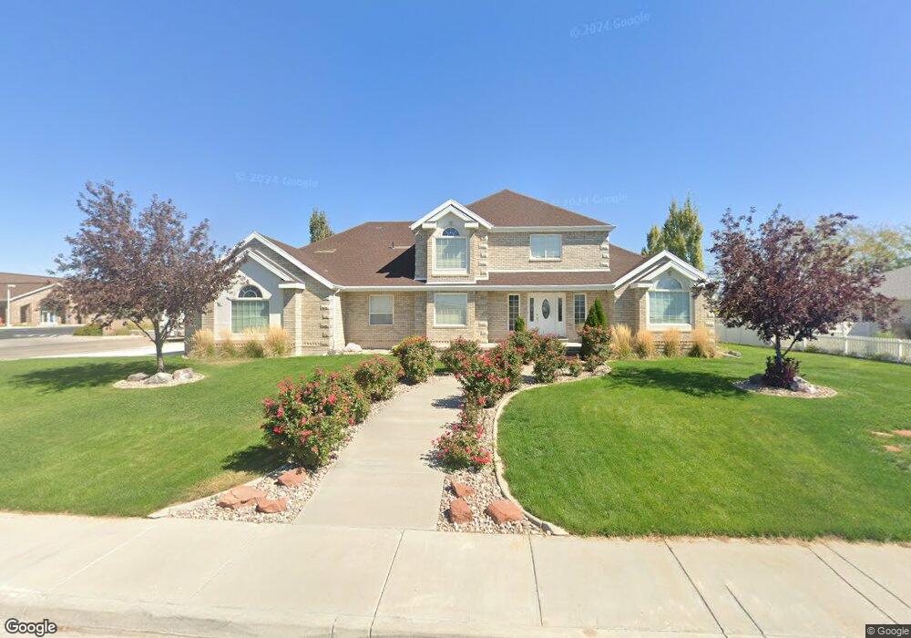
This home is located at 197 White Sage Ave, Delta, UT 84624 and is currently estimated at $606,391, approximately $94 per square foot. 197 White Sage Ave is a home located in Millard County with nearby schools including Cba Center and White River Academy.
Ownership History
Date
Name
Owned For
Owner Type
Purchase Details
Closed on
Dec 10, 2020
Sold by
Vanter Billie K Van De and Vanter Sheila M
Bought by
Schouten Mark and Schouten Deanna
Current Estimated Value
Home Financials for this Owner
Home Financials are based on the most recent Mortgage that was taken out on this home.
Original Mortgage
$179,000
Outstanding Balance
$158,921
Interest Rate
2.8%
Mortgage Type
New Conventional
Estimated Equity
$447,470
Create a Home Valuation Report for This Property
The Home Valuation Report is an in-depth analysis detailing your home's value as well as a comparison with similar homes in the area
Home Values in the Area
Average Home Value in this Area
Purchase History
| Date | Buyer | Sale Price | Title Company |
|---|---|---|---|
| Schouten Mark | -- | First American Title |
Source: Public Records
Mortgage History
| Date | Status | Borrower | Loan Amount |
|---|---|---|---|
| Open | Schouten Mark | $179,000 |
Source: Public Records
Tax History Compared to Growth
Tax History
| Year | Tax Paid | Tax Assessment Tax Assessment Total Assessment is a certain percentage of the fair market value that is determined by local assessors to be the total taxable value of land and additions on the property. | Land | Improvement |
|---|---|---|---|---|
| 2025 | $5,464 | $585,037 | $32,141 | $552,896 |
| 2024 | $5,464 | $486,327 | $23,514 | $462,813 |
| 2023 | $5,823 | $486,327 | $23,514 | $462,813 |
| 2022 | $4,682 | $352,516 | $26,297 | $326,219 |
| 2021 | $3,976 | $285,845 | $19,544 | $266,301 |
| 2020 | $3,390 | $242,190 | $15,635 | $226,555 |
| 2019 | $2,914 | $208,335 | $15,635 | $192,700 |
| 2018 | $2,669 | $192,424 | $15,635 | $176,789 |
| 2017 | $2,764 | $191,969 | $15,180 | $176,789 |
| 2016 | $2,623 | $187,762 | $10,973 | $176,789 |
| 2015 | $2,622 | $187,762 | $10,973 | $176,789 |
| 2014 | -- | $191,167 | $10,973 | $180,194 |
| 2013 | -- | $191,167 | $10,973 | $180,194 |
Source: Public Records
Map
Nearby Homes
- 665 Bristlecone Ln
- 263 Silver Maple Dr
- 786 Bristlecone Ln
- Locust Ave Unit LotWP001
- 625 E Birch Dr
- 321 E 200 S
- 44 E 300 S
- 445 Topaz Blvd Unit 10
- 461 Topaz Blvd Unit 6
- 7900 E 250 Rd N
- 0 E Highway 6 Unit LotWP001 16586023
- 629 E Millard St
- 628 Sunset St
- 2595 E 500 Rd S Unit 3
- 38 E 300 S
- 32 E 300 S
- 328 S Center St
- 163 W 100 S
- 901 E 750 Rd N
- 325 N 100 W
- 213 White Sage Ave
- 223 White Sage Ave
- 260 Cottonwood Dr
- 257 Cottonwood Dr
- 270 Cottonwood Dr
- 267 Cottonwood Dr
- 280 Cottonwood Dr
- 272 Silver Maple Dr
- 277 Cottonwood Dr
- 681 Bristlecone Ln
- 266 Silver Maple Dr
- 206 S Locust Ave
- 218 S Locust Ave
- 320 Juniper St
- 705 Bristlecone Ln
- 196 S Locust Ave
- 182 S Locust Ave
- 176 S Locust Ave
- 238 S Locust Ave
- 657 Bristlecone Ln