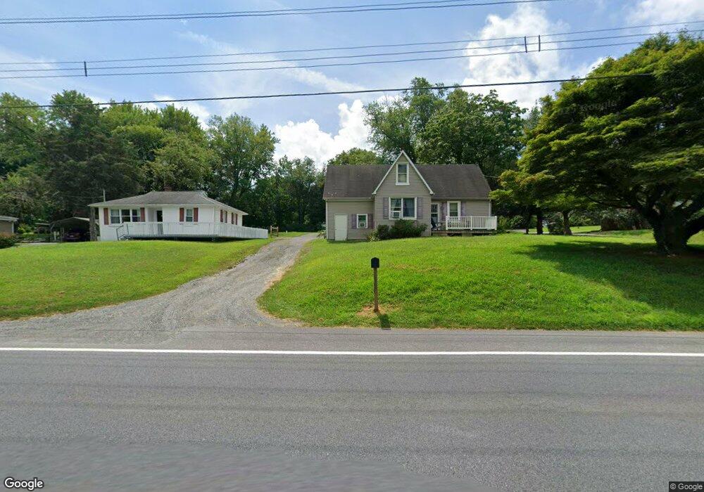
1972 Conowingo Rd Rising Sun, MD 21911
Estimated Value: $257,000 - $299,000
--
Bed
1
Bath
1,208
Sq Ft
$229/Sq Ft
Est. Value
About This Home
This home is located at 1972 Conowingo Rd, Rising Sun, MD 21911 and is currently estimated at $276,915, approximately $229 per square foot. 1972 Conowingo Rd is a home located in Cecil County with nearby schools including Rising Sun Elementary School, Rising Sun Middle School, and Rising Sun High School.
Ownership History
Date
Name
Owned For
Owner Type
Purchase Details
Closed on
Sep 29, 1990
Sold by
Wayne Henry P
Bought by
Whitecavage Frank J and Whitecavage Violet
Current Estimated Value
Purchase Details
Closed on
May 27, 1986
Sold by
Robertson Isolene
Bought by
Wayne Henry P
Home Financials for this Owner
Home Financials are based on the most recent Mortgage that was taken out on this home.
Original Mortgage
$49,999
Interest Rate
10.36%
Create a Home Valuation Report for This Property
The Home Valuation Report is an in-depth analysis detailing your home's value as well as a comparison with similar homes in the area
Home Values in the Area
Average Home Value in this Area
Purchase History
| Date | Buyer | Sale Price | Title Company |
|---|---|---|---|
| Whitecavage Frank J | $32,000 | -- | |
| Wayne Henry P | $25,100 | -- |
Source: Public Records
Mortgage History
| Date | Status | Borrower | Loan Amount |
|---|---|---|---|
| Previous Owner | Wayne Henry P | $49,999 |
Source: Public Records
Tax History Compared to Growth
Tax History
| Year | Tax Paid | Tax Assessment Tax Assessment Total Assessment is a certain percentage of the fair market value that is determined by local assessors to be the total taxable value of land and additions on the property. | Land | Improvement |
|---|---|---|---|---|
| 2025 | $1,899 | $168,000 | $78,800 | $89,200 |
| 2024 | $1,835 | $162,167 | $0 | $0 |
| 2023 | $1,787 | $156,333 | $0 | $0 |
| 2022 | $1,755 | $150,500 | $78,800 | $71,700 |
| 2021 | $1,745 | $147,833 | $0 | $0 |
| 2020 | $1,734 | $145,167 | $0 | $0 |
| 2019 | $1,704 | $142,500 | $78,800 | $63,700 |
| 2018 | $1,704 | $142,500 | $78,800 | $63,700 |
| 2017 | $1,704 | $142,500 | $0 | $0 |
| 2016 | $1,720 | $150,500 | $0 | $0 |
| 2015 | $1,720 | $150,500 | $0 | $0 |
| 2014 | $1,607 | $150,500 | $0 | $0 |
Source: Public Records
Map
Nearby Homes
- 1964 Conowingo Rd
- 91 Mountain Rd
- 66 Spready Oak Rd
- 89 Codjus Dr
- Lots 126-127 Codjus Dr
- 113 Turtleback Ct
- 585 Pearl St
- 62 Porters Bridge Rd
- 0 Colora Rd
- 97 W Kanawha Dr
- 1741 Liberty Grove Rd
- 152 Hopewell Rd
- 43 Pearl St
- 27 Haines Ave
- 0 Ridge Rd Unit MDCC2018338
- 10 N Hills Dr
- 96 Sunrise Dr
- 283 Joseph Biggs Memorial Hwy
- 0 Boyd Dr
- 67 Merry Knoll Ct
- 1972 Conowingo Rd
- 1972C Conowingo Rd
- 1982 Conowingo Rd
- 1974 Conowingo Rd
- 1986 Conowingo Rd
- 1994 Conowingo Rd
- 2002 Conowingo Rd
- 2010 Conowingo Rd
- 1960 Conowingo Rd
- 79 Mountain Rd
- 1950 Conowingo Rd
- 95 Mountain Rd
- 2018 Conowingo Rd
- 43 Mountain Rd
- 2026 Conowingo Rd
- 1948 Conowingo Rd
- 2032 Conowingo Rd
- 73 Mountain Rd
- 25 Mountain Rd
- 1936 Conowingo Rd