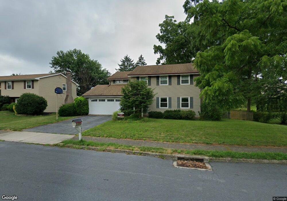
1973 Linden Ln Whitehall, PA 18052
Fullerton NeighborhoodEstimated Value: $437,794 - $506,000
4
Beds
3
Baths
2,006
Sq Ft
$235/Sq Ft
Est. Value
About This Home
This home is located at 1973 Linden Ln, Whitehall, PA 18052 and is currently estimated at $471,199, approximately $234 per square foot. 1973 Linden Ln is a home located in Lehigh County with nearby schools including Zephyr Elementary School, Clarence M Gockley Elementary School, and George D Steckel Elementary School.
Ownership History
Date
Name
Owned For
Owner Type
Purchase Details
Closed on
Aug 26, 1999
Sold by
Mcknight Peter A and Mcknight Carolyn R
Bought by
Sywensky William J and Sywensky Ann E
Current Estimated Value
Purchase Details
Closed on
Jul 30, 1993
Sold by
Turbedsky Gregory P and Turbedsky Veronica J
Bought by
Mcknight Peter A and Mcknight Carolyn R
Create a Home Valuation Report for This Property
The Home Valuation Report is an in-depth analysis detailing your home's value as well as a comparison with similar homes in the area
Home Values in the Area
Average Home Value in this Area
Purchase History
| Date | Buyer | Sale Price | Title Company |
|---|---|---|---|
| Sywensky William J | $167,500 | -- | |
| Mcknight Peter A | $157,500 | -- |
Source: Public Records
Tax History Compared to Growth
Tax History
| Year | Tax Paid | Tax Assessment Tax Assessment Total Assessment is a certain percentage of the fair market value that is determined by local assessors to be the total taxable value of land and additions on the property. | Land | Improvement |
|---|---|---|---|---|
| 2025 | $6,852 | $233,700 | $33,900 | $199,800 |
| 2024 | $6,622 | $233,700 | $33,900 | $199,800 |
| 2023 | $6,485 | $233,700 | $33,900 | $199,800 |
| 2022 | $6,338 | $233,700 | $199,800 | $33,900 |
| 2021 | $6,233 | $233,700 | $33,900 | $199,800 |
| 2020 | $5,994 | $233,700 | $33,900 | $199,800 |
| 2019 | $5,527 | $233,700 | $33,900 | $199,800 |
| 2018 | $5,383 | $233,700 | $33,900 | $199,800 |
| 2017 | $5,327 | $235,600 | $33,900 | $201,700 |
| 2016 | -- | $235,600 | $33,900 | $201,700 |
| 2015 | -- | $235,600 | $33,900 | $201,700 |
| 2014 | -- | $235,600 | $33,900 | $201,700 |
Source: Public Records
Map
Nearby Homes
- 1733 Elmhurst Dr
- 1924 Alberta Dr
- 2101 Van Buren Dr
- 109 Johnson Ct
- 36 Peachtree Cir
- 1844 Schadt Ave
- 195 Shiloh Ct
- 2 Grantarthur #Franklin Ct
- 1 Grantartur #Taylor Ct
- 4 Grantarthur #Morris Ct
- 3 Grantarthur #Liberty Ct
- 1 Grantarthur #Taylor Ct
- 1313 Hemlock Dr
- 1590 Abigail Ln Unit LOT 59
- 1573 Abigail Ln
- 2020 Whitehall Ave
- 1640 Alta Dr
- 1575 Creekside Rd Unit 21
- 1553 Creekside Rd Unit B23
- 1739 N 21st St
- 1975 Linden Ln
- 1971 Linden Ln
- 1977 Linden Ln
- 1803 Elmhurst Dr
- 1968 Linden Ln
- 1805 Elmhurst Dr
- 1970 Linden Ln
- 1972 Linden Ln
- 1969 Linden Ln
- 1974 Linden Ln
- 1807 Elmhurst Dr
- 1976 Linden Ln
- 1944 Belleview Dr
- 1942 Belleview Dr
- 1981 Linden Ln
- 1949 Ronald Dr
- 1978 Linden Ln
- 1804 Elmhurst Dr
- 1946 Belleview Dr