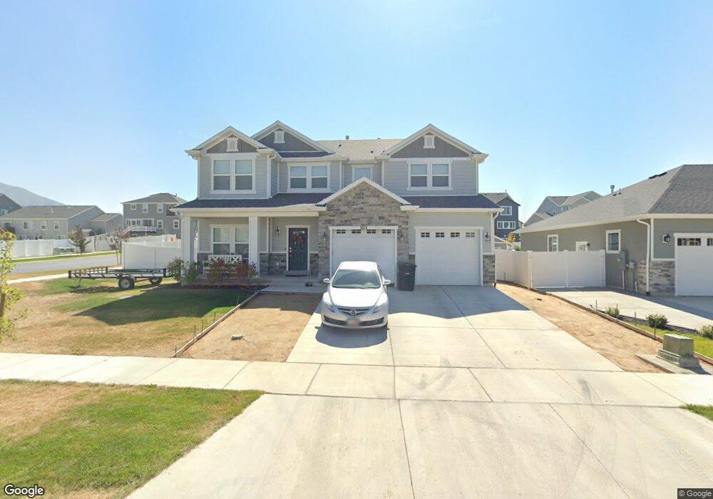
1974 E 970 N Spanish Fork, UT 84660
Estimated Value: $674,000 - $694,349
4
Beds
3
Baths
3,872
Sq Ft
$176/Sq Ft
Est. Value
About This Home
This home is located at 1974 E 970 N, Spanish Fork, UT 84660 and is currently estimated at $681,116, approximately $175 per square foot. 1974 E 970 N is a home located in Utah County with nearby schools including Rees Elementary School, Mapleton Junior High School, and Maple Mountain High School.
Ownership History
Date
Name
Owned For
Owner Type
Purchase Details
Closed on
Aug 11, 2022
Sold by
Richard Stephenson
Bought by
Stephenson Richard and Stephenson Elizabeth
Current Estimated Value
Home Financials for this Owner
Home Financials are based on the most recent Mortgage that was taken out on this home.
Original Mortgage
$631,750
Outstanding Balance
$603,985
Interest Rate
5.51%
Mortgage Type
New Conventional
Estimated Equity
$77,131
Purchase Details
Closed on
Oct 30, 2019
Sold by
Fieldstone Legacy Farms Llc
Bought by
Hayes Timothy J and Hayes Crystal T
Home Financials for this Owner
Home Financials are based on the most recent Mortgage that was taken out on this home.
Original Mortgage
$265,900
Interest Rate
3.7%
Mortgage Type
New Conventional
Create a Home Valuation Report for This Property
The Home Valuation Report is an in-depth analysis detailing your home's value as well as a comparison with similar homes in the area
Home Values in the Area
Average Home Value in this Area
Purchase History
| Date | Buyer | Sale Price | Title Company |
|---|---|---|---|
| Stephenson Richard | -- | None Listed On Document | |
| Stephenson Richard | -- | None Listed On Document | |
| Hayes Timothy J | -- | Bartlett Title Ins Agcy Inc |
Source: Public Records
Mortgage History
| Date | Status | Borrower | Loan Amount |
|---|---|---|---|
| Open | Stephenson Richard | $631,750 | |
| Previous Owner | Hayes Timothy J | $265,900 |
Source: Public Records
Tax History
| Year | Tax Paid | Tax Assessment Tax Assessment Total Assessment is a certain percentage of the fair market value that is determined by local assessors to be the total taxable value of land and additions on the property. | Land | Improvement |
|---|---|---|---|---|
| 2025 | $3,138 | $366,630 | -- | -- |
| 2024 | $3,138 | $323,455 | $0 | $0 |
| 2023 | $3,196 | $329,835 | $0 | $0 |
| 2022 | $3,442 | $348,315 | $0 | $0 |
| 2021 | $2,980 | $482,400 | $143,400 | $339,000 |
| 2020 | $2,946 | $463,700 | $130,400 | $333,300 |
Source: Public Records
Map
Nearby Homes
- 1846 Freight Wagon Ln Unit CONCRD
- 893 N Spring Ln
- 1079 N Carriage Ln Unit STANTO
- 853 N Haywain Dr
- 663 N 2040 E
- 1682 E Ridgefield Rd
- 1154 N Golden Spoke Dr
- 1213 Firefly Dr
- 1187 Dragonfly Ln
- 1282 Lily Pad Dr
- 1164 N Ponderosa Ln
- 1327 Lily Pad Dr
- 1228 Cattail Dr
- 1355 N 1980 E
- 365 Slant Rd Unit 29
- 708 N Plainsman Dr
- 934 N Laredo Dr
- 2567 E 830 N
- 669 N Plainsman Dr
- 1524 N 1870 E Unit 736
Your Personal Tour Guide
Ask me questions while you tour the home.