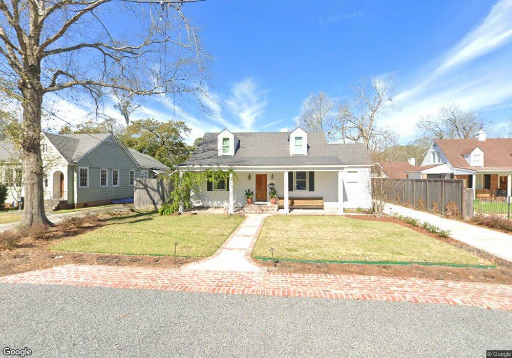
1975 Myrtledale Ave Baton Rouge, LA 70808
Highlands/Perkins NeighborhoodEstimated Value: $370,000 - $460,000
3
Beds
2
Baths
2,100
Sq Ft
$201/Sq Ft
Est. Value
About This Home
This home is located at 1975 Myrtledale Ave, Baton Rouge, LA 70808 and is currently estimated at $422,871, approximately $201 per square foot. 1975 Myrtledale Ave is a home located in East Baton Rouge Parish with nearby schools including Buchanan Elementary School, Glasgow Middle School, and Mckinley Senior High School.
Ownership History
Date
Name
Owned For
Owner Type
Purchase Details
Closed on
Aug 4, 2000
Sold by
Gibson Gibson Daniel Wayne
Bought by
Wood Phillip Rodney and Wood Karen Rebecca Hunter
Current Estimated Value
Home Financials for this Owner
Home Financials are based on the most recent Mortgage that was taken out on this home.
Original Mortgage
$65,000
Outstanding Balance
$23,552
Interest Rate
8.21%
Estimated Equity
$399,319
Create a Home Valuation Report for This Property
The Home Valuation Report is an in-depth analysis detailing your home's value as well as a comparison with similar homes in the area
Home Values in the Area
Average Home Value in this Area
Purchase History
| Date | Buyer | Sale Price | Title Company |
|---|---|---|---|
| Wood Phillip Rodney | $189,000 | -- |
Source: Public Records
Mortgage History
| Date | Status | Borrower | Loan Amount |
|---|---|---|---|
| Open | Wood Phillip Rodney | $65,000 |
Source: Public Records
Tax History Compared to Growth
Tax History
| Year | Tax Paid | Tax Assessment Tax Assessment Total Assessment is a certain percentage of the fair market value that is determined by local assessors to be the total taxable value of land and additions on the property. | Land | Improvement |
|---|---|---|---|---|
| 2024 | $3,106 | $33,250 | $7,500 | $25,750 |
| 2023 | $3,106 | $33,250 | $7,500 | $25,750 |
| 2022 | $3,970 | $33,250 | $7,500 | $25,750 |
| 2021 | $3,879 | $33,250 | $7,500 | $25,750 |
| 2020 | $3,854 | $33,250 | $7,500 | $25,750 |
| 2019 | $3,361 | $27,750 | $7,500 | $20,250 |
| 2018 | $3,319 | $27,750 | $7,500 | $20,250 |
| 2017 | $3,319 | $27,750 | $7,500 | $20,250 |
| 2016 | $2,459 | $27,750 | $7,500 | $20,250 |
| 2015 | $1,820 | $22,250 | $7,500 | $14,750 |
| 2014 | $1,814 | $22,250 | $7,500 | $14,750 |
| 2013 | -- | $22,250 | $7,500 | $14,750 |
Source: Public Records
Map
Nearby Homes
- 2024 Myrtledale Ave
- 1824 Myrtledale Ave
- 1937 Cedardale Ave
- 2182 Stanford Ave
- 3109 E Lakeshore Dr
- 1828 Cloverdale Ave
- 3147 E Lakeshore Dr
- 3381 E Lakeshore Dr
- 2267 Cedardale Ave
- 1509 Stanford Ave Unit A3
- 2198 Christian St
- 2192 Christian St
- 1525 Hood Ave
- 4025 Perkins Lane Alley
- 2529 Fiero St
- 2247 Christian St
- 2603 E Lakeshore Dr
- 2619 E Lakeshore Dr
- 4013 Hyacinth Ave
- 3616 S Lakeshore Dr
- 2021 Myrtledale Ave
- 1961 Myrtledale Ave
- 2010 Glendale Ave
- 2037 Myrtledale Ave
- 2022 Glendale Ave
- 1970 Glendale Ave
- 1966 Myrtledale Ave
- 2012 Myrtledale Ave
- 1956 Glendale Ave
- 2034 Glendale Ave
- 1935 Myrtledale Ave
- 2047 Myrtledale Ave
- 2036 Myrtledale Ave
- 1946 Myrtledale Ave
- 1940 Glendale Ave
- 2050 Glendale Ave
- 1936 Myrtledale Ave
- 2069 Myrtledale Ave
- 3373 Morning Glory Ave
- 3359 Morning Glory Ave