


1975 Peakland Dr Pulaski, VA 24301
Estimated payment $882/month
Highlights
- Deck
- Private Yard
- Manufactured Home
- Main Floor Primary Bedroom
- No HOA
About This Home
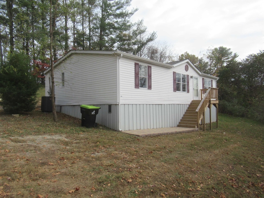
Just remodeled home, new heat pump, roof, appliances, under pinning, all new laminate flooring, new paint, baths and kitchen updated. New decks, ready to move in. Foundation Certification completed.
Property Details
Home Type
- Manufactured Home
Year Built
- Built in 2000 | Remodeled
Lot Details
- 0.45 Acre Lot
- Private Yard
Home Design
- 1,232 Sq Ft Home
- Single Family Detached Home
- Vinyl Trim
Kitchen
- Electric Range
- Microwave
Bedrooms and Bathrooms
- 3 Main Level Bedrooms
- Primary Bedroom on Main
- 2 Full Bathrooms
Schools
- Pulaski Elementary School
- Pulaski County Middle School
- Pulaski County High School
Utilities
- Heat Pump System
- Electric Water Heater
Additional Features
- Deck
- Manufactured Home
Community Details
- No Home Owners Association
Listing and Financial Details
- Assessor Parcel Number 07300300000024
Map
Home Values in the Area
Average Home Value in this Area
Tax History
| Year | Tax Paid | Tax Assessment Tax Assessment Total Assessment is a certain percentage of the fair market value that is determined by local assessors to be the total taxable value of land and additions on the property. | Land | Improvement |
|---|---|---|---|---|
| 2025 | $518 | $70,000 | $20,000 | $50,000 |
| 2024 | $518 | $70,000 | $20,000 | $50,000 |
| 2023 | $518 | $70,000 | $20,000 | $50,000 |
| 2022 | $518 | $70,000 | $20,000 | $50,000 |
| 2021 | $518 | $70,000 | $20,000 | $50,000 |
| 2020 | $473 | $61,400 | $18,000 | $43,400 |
| 2019 | $473 | $61,400 | $18,000 | $43,400 |
| 2018 | $473 | $61,400 | $18,000 | $43,400 |
| 2017 | $393 | $61,400 | $18,000 | $43,400 |
| 2016 | $393 | $61,400 | $18,000 | $43,400 |
| 2015 | $393 | $61,400 | $18,000 | $43,400 |
| 2014 | $428 | $72,600 | $18,000 | $54,600 |
| 2013 | $428 | $72,600 | $18,000 | $54,600 |
Property History
| Date | Event | Price | List to Sale | Price per Sq Ft |
|---|---|---|---|---|
| 10/28/2025 10/28/25 | Pending | -- | -- | -- |
| 10/27/2025 10/27/25 | For Sale | $159,500 | -- | $129 / Sq Ft |
Purchase History
| Date | Type | Sale Price | Title Company |
|---|---|---|---|
| Deed | $19,000 | New Century Title | |
| Deed | -- | New Century Title | |
| Deed | -- | None Listed On Document | |
| Warranty Deed | $59,900 | -- | |
| Deed | -- | None Available |
Source: New River Valley Association of REALTORS®
MLS Number: 425679
APN: 21633
Disclaimer: Certain information contained herein is derived from information provided by parties other than Homes.com. All information provided is deemed reliable, but is not guaranteed to be accurate and should be independently verified.
![]() IDX information is provided exclusively for personal, non-commercial use, and may not be used for any purpose other than to identify prospective properties consumers may be interested in purchasing. Information is deemed reliable but not guaranteed.
IDX information is provided exclusively for personal, non-commercial use, and may not be used for any purpose other than to identify prospective properties consumers may be interested in purchasing. Information is deemed reliable but not guaranteed.
- 1960 Peakland Dr
- 1918 Warden Springs Rd
- 1922 Warden Springs Rd
- 1600 Claremont Ct
- 1713 Monte Vista Dr
- Lot 3 Beck Ln
- Lot 2 Beck Ln
- 1405 Grove Dr
- Lot 4 Kensington Ln
- 1217 Memorial Dr
- 1217 Allison Ln
- 1224 Macgill St
- 1200 Macgill St
- 1116 Macgill St
- 0 Peppers Ferry Rd
- Lot 1 Peppers Ferry Rd
- 1315 Peppers Ferry Rd
- 820 Newbern Rd
- 1125 Peppers Ferry Rd
- 616 Newbern Rd
