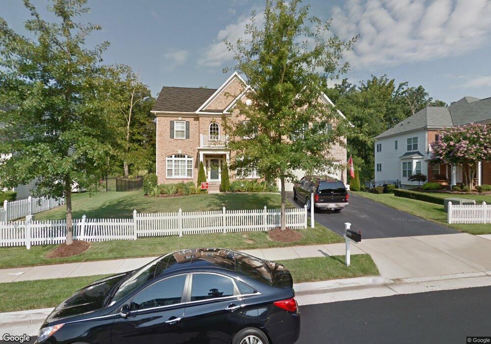
1975 Powells Landing Cir Woodbridge, VA 22191
Estimated Value: $830,963 - $942,000
5
Beds
5
Baths
3,634
Sq Ft
$246/Sq Ft
Est. Value
About This Home
This home is located at 1975 Powells Landing Cir, Woodbridge, VA 22191 and is currently estimated at $893,241, approximately $245 per square foot. 1975 Powells Landing Cir is a home located in Prince William County with nearby schools including Leesylvania Elementary School, Potomac Middle School, and Potomac High School.
Ownership History
Date
Name
Owned For
Owner Type
Purchase Details
Closed on
Sep 30, 2024
Sold by
Turk Robert Wayne and Turk Veronica
Bought by
Turk Family Trust and Turk
Current Estimated Value
Purchase Details
Closed on
Jun 14, 2007
Sold by
Pwells Neighborhoods Ii L
Bought by
Turk Robert W
Home Financials for this Owner
Home Financials are based on the most recent Mortgage that was taken out on this home.
Original Mortgage
$524,000
Interest Rate
6.19%
Mortgage Type
New Conventional
Create a Home Valuation Report for This Property
The Home Valuation Report is an in-depth analysis detailing your home's value as well as a comparison with similar homes in the area
Home Values in the Area
Average Home Value in this Area
Purchase History
| Date | Buyer | Sale Price | Title Company |
|---|---|---|---|
| Turk Family Trust | -- | None Listed On Document | |
| Turk Robert W | $655,000 | -- |
Source: Public Records
Mortgage History
| Date | Status | Borrower | Loan Amount |
|---|---|---|---|
| Previous Owner | Turk Robert W | $524,000 |
Source: Public Records
Tax History Compared to Growth
Tax History
| Year | Tax Paid | Tax Assessment Tax Assessment Total Assessment is a certain percentage of the fair market value that is determined by local assessors to be the total taxable value of land and additions on the property. | Land | Improvement |
|---|---|---|---|---|
| 2025 | -- | $802,700 | $241,100 | $561,600 |
| 2024 | -- | $773,200 | $231,900 | $541,300 |
| 2023 | $7,693 | $739,400 | $220,900 | $518,500 |
| 2022 | $7,731 | $694,100 | $206,500 | $487,600 |
| 2021 | $7,530 | $625,500 | $186,100 | $439,400 |
| 2020 | $9,083 | $586,000 | $175,600 | $410,400 |
| 2019 | $8,874 | $572,500 | $170,500 | $402,000 |
| 2018 | $6,583 | $545,200 | $162,400 | $382,800 |
| 2017 | $6,657 | $542,600 | $160,900 | $381,700 |
| 2016 | $7,013 | $577,700 | $165,800 | $411,900 |
| 2015 | $7,058 | $584,300 | $167,500 | $416,800 |
| 2014 | $7,058 | $569,100 | $162,700 | $406,400 |
Source: Public Records
Map
Nearby Homes
- 16309 Sandy Ridge Ct
- 2114 Jellico Ct
- 16830 Tidewater Ct
- 16660 Bolling Brook Ct
- 16068 Hayes Ln
- 16862 Reef Knot Way
- 16363 Rusty Rudder Dr
- 2424 Five Fathom Cir
- 16559 Bramblewood Ln
- 16518 Bobster Ct
- 2620 Cast Off Loop
- 2610 Grayton Ln
- 2679 Cast Off Loop
- 17080 Belle Isle Dr
- 2606 Oak Valley Dr
- 16879 Sea Lawn Place
- 2728 Brier Pond Cir
- 2756 Brier Pond Cir
- 17239 Miss Packard Ct
- 16249 Chase Eagle Ln
- 1979 Powells Landing Cir
- 1971 Powells Landing Cir
- 0 Powells Landing Cir Unit PW7300726
- 0 Powells Landing Cir Unit PW7300725
- 0 Powells Landing Cir Unit PW7300723
- 0 Powells Landing Cir Unit PW7300722
- 0 Powells Landing Cir Unit PW7145514
- 0 Powells Landing Cir Unit PW7081068
- 0 Powells Landing Cir Unit PW6338932
- 0 Powells Landing Cir Unit PW7145521
- 0 Powells Landing Cir Unit PW7145518
- 0 Powells Landing Cir Unit PW7145516
- 0 Powells Landing Cir Unit PW6230241
- 0 Powells Landing Cir Unit 1009072800
- 0 Powells Landing Cir Unit 1009072792
- 0 Powells Landing Cir Unit 1009072786
- 0 Powells Landing Cir Unit 1009072770
- 0 Powells Landing Cir Unit 1008919906
- 0 Powells Landing Cir Unit 1008919884
- 0 Powells Landing Cir Unit 1008919878