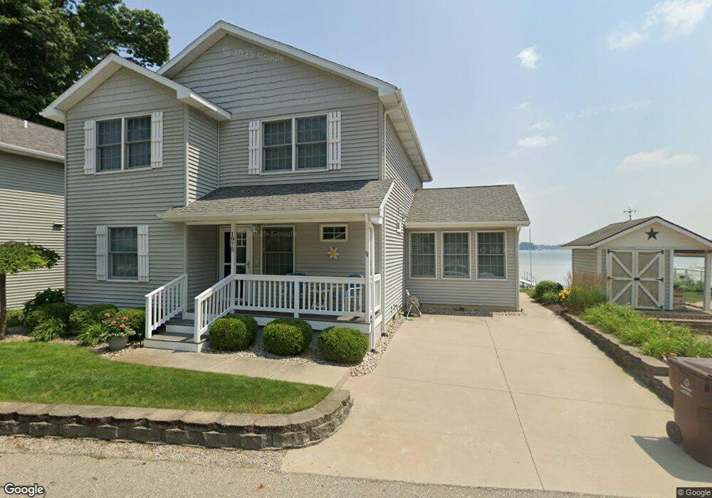
1975 Strait Tow Blvd Crystal, MI 48818
Estimated Value: $476,000 - $554,832
4
Beds
2
Baths
2,248
Sq Ft
$235/Sq Ft
Est. Value
About This Home
This home is located at 1975 Strait Tow Blvd, Crystal, MI 48818 and is currently estimated at $527,277, approximately $234 per square foot. 1975 Strait Tow Blvd is a home located in Montcalm County with nearby schools including Central Montcalm Elementary School, Central Montcalm Upper Elementary School, and Central Montcalm Middle School.
Ownership History
Date
Name
Owned For
Owner Type
Purchase Details
Closed on
Dec 11, 2020
Sold by
Richard T Dalton T
Bought by
Sally D Dalton T
Current Estimated Value
Purchase Details
Closed on
Nov 3, 2010
Sold by
Dalton Sally D and Dalton Richard T
Bought by
Dalton Richard T and Dalton Sally D
Purchase Details
Closed on
Apr 11, 2007
Sold by
Delp Ronnie L and Delp Lisa S
Bought by
Dalton Richard T and Dalton Sally D
Purchase Details
Closed on
Jul 6, 2001
Sold by
Pope Martha Trust
Bought by
Dalton Dalton R and Dalton L
Purchase Details
Closed on
Apr 17, 2001
Sold by
Pope Dean and Pope Martha
Bought by
Delp Ron and Delp Lisa
Purchase Details
Closed on
Jul 10, 1997
Sold by
Bakker Gerrit H
Bought by
Pope Dean and Martha Trusts
Purchase Details
Closed on
Nov 14, 1995
Sold by
U'Ren Darwin R
Bought by
Pope Dean and Pope Martha
Create a Home Valuation Report for This Property
The Home Valuation Report is an in-depth analysis detailing your home's value as well as a comparison with similar homes in the area
Purchase History
| Date | Buyer | Sale Price | Title Company |
|---|---|---|---|
| Sally D Dalton T | -- | None Available | |
| Dalton Richard T | -- | -- | |
| Dalton Richard T | -- | -- | |
| Dalton Dalton R | -- | -- | |
| Delp Ron | $250,000 | -- | |
| Pope Dean | $1,000 | -- | |
| Pope Dean | $159,900 | -- |
Source: Public Records
Tax History
| Year | Tax Paid | Tax Assessment Tax Assessment Total Assessment is a certain percentage of the fair market value that is determined by local assessors to be the total taxable value of land and additions on the property. | Land | Improvement |
|---|---|---|---|---|
| 2025 | $6,393 | $265,600 | $0 | $0 |
| 2024 | $6,654 | $252,900 | $0 | $0 |
| 2023 | -- | $188,000 | $0 | $0 |
Source: Public Records
Map
Nearby Homes
- 2100 Strait Tow Blvd
- 890 S Senator Rd
- 8386 E Sidney Rd
- 2695 Ovid St
- 1283 S Waldron Rd
- 802 Parker St
- 305 E Lasalle St
- 8652 E Colby Rd
- 4337 Holland Lake Rd
- 1050 Wicker Rd SE
- 3545 S Roy Dr
- 4218 E Klees Rd
- 5019 S Townhall Rd
- 152 W Holland Lake Dr
- 7518 S Crystal Rd
- V/L Lilac Ln
- 1020 Joshua Dr
- 4599 Creek View Ct
- 4575 Creek View Ct
- 4685 Meadow View Dr
- 1973 Strait Tow Blvd
- 1999 Strait Tow Blvd
- 1971 Strait Tow Blvd
- 2001 Strait Tow Blvd
- 1996 Strait Tow Blvd
- 1978 Strait Tow Blvd
- 2002 Strait Tow Blvd
- 1965 Strait Tow Blvd
- 1974 Strait Tow Blvd
- 1972 Strait Tow Blvd
- 1974 Mildred St
- 2003 Strait Tow Blvd
- 1970 Strait Tow Blvd
- 2006 Strait Tow Blvd
- 2006 Strait Tow Blvd
- 2004 Mildred St
- 1976 Mildred St
- 1963 Strait Tow Blvd
- 2007 Strait Tow Blvd
- 1966 Strait Tow Blvd
Your Personal Tour Guide
Ask me questions while you tour the home.