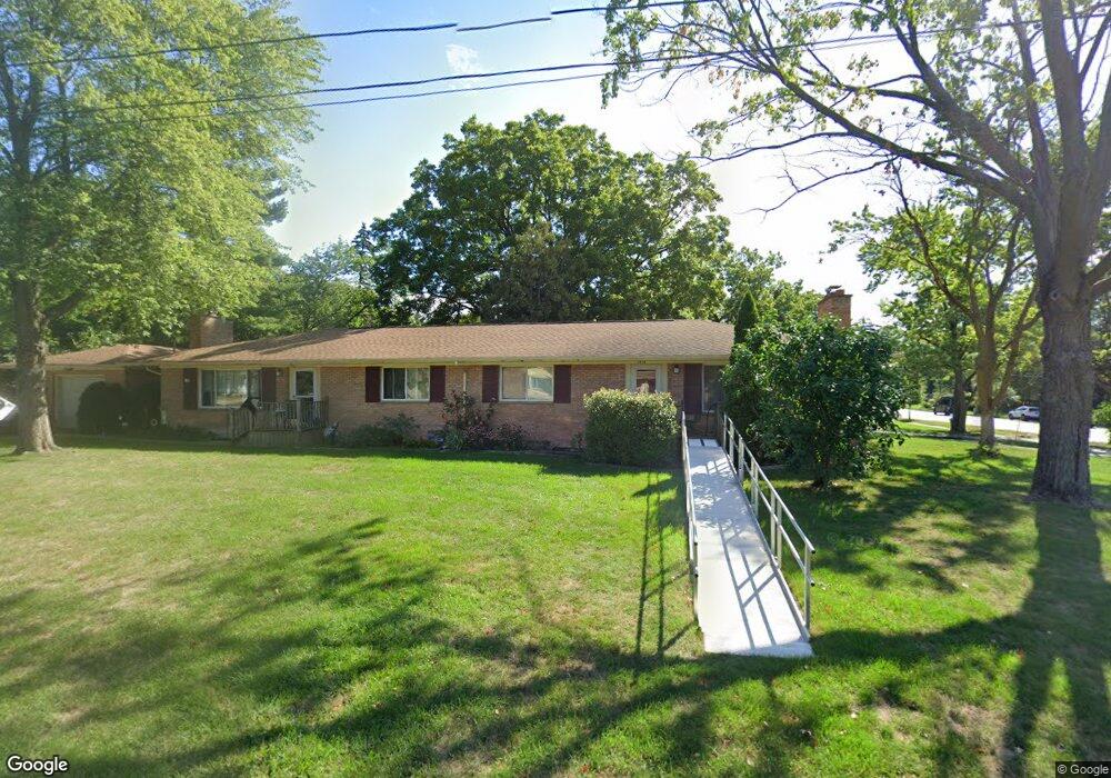
1976 Radcliff Ave SE Grand Rapids, MI 49506
Estimated Value: $371,000 - $482,000
--
Bed
--
Bath
2,079
Sq Ft
$210/Sq Ft
Est. Value
About This Home
This home is located at 1976 Radcliff Ave SE, Grand Rapids, MI 49506 and is currently estimated at $437,313, approximately $210 per square foot. 1976 Radcliff Ave SE is a home located in Kent County with nearby schools including Mulick Park Elementary School, Alger Middle School, and Ottawa Hills High School.
Ownership History
Date
Name
Owned For
Owner Type
Purchase Details
Closed on
Dec 30, 2016
Sold by
Bosseh Proet Llc
Bought by
Boerema Norman and Boerema Terri
Current Estimated Value
Purchase Details
Closed on
Feb 7, 2006
Sold by
Bosscher Florence A
Bought by
Bosscher Properties Llc
Purchase Details
Closed on
May 31, 1994
Sold by
Bosscher Bosscher R R and Bosscher Bsschr F
Bought by
Bosscher Properties Llc
Purchase Details
Closed on
May 30, 1994
Sold by
Dotem Dotem D D and Dotem Bosscher R
Bought by
Bosscher Properties Llc
Purchase Details
Closed on
Oct 11, 1988
Create a Home Valuation Report for This Property
The Home Valuation Report is an in-depth analysis detailing your home's value as well as a comparison with similar homes in the area
Home Values in the Area
Average Home Value in this Area
Purchase History
| Date | Buyer | Sale Price | Title Company |
|---|---|---|---|
| Boerema Norman | $165,000 | Sun Title Agency Of Michigan | |
| Bosscher Properties Llc | -- | None Available | |
| Bosscher Properties Llc | $97,000 | -- | |
| Bosscher Properties Llc | $83,000 | -- | |
| -- | $41,000 | -- |
Source: Public Records
Tax History Compared to Growth
Tax History
| Year | Tax Paid | Tax Assessment Tax Assessment Total Assessment is a certain percentage of the fair market value that is determined by local assessors to be the total taxable value of land and additions on the property. | Land | Improvement |
|---|---|---|---|---|
| 2025 | $5,334 | $197,500 | $0 | $0 |
| 2024 | $5,334 | $170,400 | $0 | $0 |
| 2023 | $5,291 | $146,300 | $0 | $0 |
| 2022 | $5,028 | $135,700 | $0 | $0 |
| 2021 | $4,899 | $124,200 | $0 | $0 |
| 2020 | $4,735 | $113,300 | $0 | $0 |
| 2019 | $4,848 | $92,900 | $0 | $0 |
| 2018 | $4,700 | $90,700 | $0 | $0 |
| 2017 | $4,585 | $93,800 | $0 | $0 |
| 2016 | $4,706 | $90,400 | $0 | $0 |
| 2015 | $4,484 | $90,400 | $0 | $0 |
| 2013 | -- | $88,500 | $0 | $0 |
Source: Public Records
Map
Nearby Homes
- 1740 Ridgemoor Dr SE
- 2245 Ridgewood Ave SE
- 2714 Colton Ave SE
- 2709 Abigail St SE
- 2745 Barfield Dr SE
- 1940 Observatory Ave SE
- 2743 Mulford Dr SE
- 2150 Rolling Hills Dr SE
- 2200 Rolling Hills Dr SE
- 3131 Lake Dr SE
- 1840 Keyhill Ave SE
- 2530 Boston St SE
- 2531 Boston St SE
- 1558 Lake Grove Ave SE
- 2524 Albert Dr SE
- 1753 Breton Rd SE
- 2350 Englewood Dr SE
- 2229 Griggs St SE Unit 5
- 2227 Griggs St SE Unit 4
- 2225 Griggs St SE Unit 3
- 3119 Burton St SE
- 3119 Burton St SE Unit 3121
- 1945 Morningside Dr SE
- 1960 Radcliff Ave SE
- 1977 Radcliff Ave SE
- 1935 Morningside Dr SE
- 1955 Radcliff Ave SE
- 3110 Burton St SE
- 1946 Radcliff Ave SE
- 2015 Radcliff Ave SE
- 1954 Woodcliff Ave SE
- 1925 Morningside Dr SE
- 1956 Morningside Dr SE
- 1945 Radcliff Ave SE
- 1946 Morningside Dr SE
- 3050 Burton St SE
- 1942 Woodcliff Ave SE
- 2020 Radcliff Ave SE
- 1936 Morningside Dr SE
- 1930 Radcliff Ave SE