Estimated Value: $341,503 - $610,000
Studio
--
Bath
--
Sq Ft
3,485
Sq Ft Lot Lot
About This Home
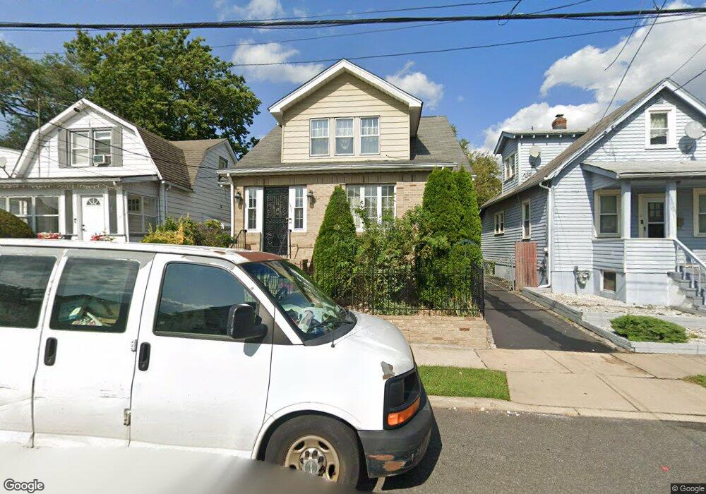
This home is located at 1977 William St, Union, NJ 07083 and is currently estimated at $477,376. 1977 William St is a home located in Union County with nearby schools including Franklin Elementary School, Burnet Middle School, and Union High School.
Ownership History
Date
Name
Owned For
Owner Type
Purchase Details
Closed on
Sep 28, 2001
Sold by
Abreu Eddie M and Abreu Mylene
Bought by
Bryan Evett Layne and Bryan Murtland
Current Estimated Value
Home Financials for this Owner
Home Financials are based on the most recent Mortgage that was taken out on this home.
Original Mortgage
$157,500
Outstanding Balance
$81,097
Interest Rate
11.37%
Estimated Equity
$396,279
Create a Home Valuation Report for This Property
The Home Valuation Report is an in-depth analysis detailing your home's value as well as a comparison with similar homes in the area
Home Values in the Area
Average Home Value in this Area
Purchase History
We collect this data history from publicly available records. To have your information removed, we recommend requesting removal directly through your county’s website.
| Date | Buyer | Sale Price | Title Company |
|---|---|---|---|
| Bryan Evett Layne | $175,000 | Fidelity National Title Ins |
Source: Public Records
Mortgage History
We collect this data history from publicly available records. To have your information removed, we recommend requesting removal directly through your county’s website.
| Date | Status | Borrower | Loan Amount |
|---|---|---|---|
| Open | Bryan Evett Layne | $157,500 |
Source: Public Records
Tax History
| Year | Tax Paid | Tax Assessment Tax Assessment Total Assessment is a certain percentage of the fair market value that is determined by local assessors to be the total taxable value of land and additions on the property. | Land | Improvement |
|---|---|---|---|---|
| 2025 | $8,806 | $39,400 | $14,400 | $25,000 |
| 2024 | $8,538 | $39,400 | $14,400 | $25,000 |
| 2023 | $8,538 | $39,400 | $14,400 | $25,000 |
| 2022 | $8,241 | $39,400 | $14,400 | $25,000 |
| 2021 | $8,041 | $39,400 | $14,400 | $25,000 |
| 2020 | $7,881 | $39,400 | $14,400 | $25,000 |
| 2019 | $7,775 | $39,400 | $14,400 | $25,000 |
| 2018 | $7,642 | $39,400 | $14,400 | $25,000 |
| 2017 | $7,529 | $39,400 | $14,400 | $25,000 |
| 2016 | $7,346 | $39,400 | $14,400 | $25,000 |
| 2015 | $7,224 | $39,400 | $14,400 | $25,000 |
| 2014 | $7,062 | $39,400 | $14,400 | $25,000 |
Source: Public Records
Map
Nearby Homes
- 1985 Ostwood Terrace
- 2031 Pleasant Pkwy
- 1629 May St
- 2 Evelyn Ct
- 22 Evelyn Ct
- 480-482 Boyden Ave
- 1508 Elaine Terrace
- 239 40th St Unit C0032
- 239 40th St Unit 32
- 11 Lentz Place
- 18 Gifford Ct
- 1515 Rose Terrace
- 306 Arsdale Terrace Unit 306
- 306 Arsdale Terrace Unit D3
- 1584 Walker Ave
- 31 Orchard Place
- 1576 Julian Terrace
- 38 Orchard Place
- 36 Orchard Place Unit 38
- 47 Lindsley Ave
- 1979 William St
- 1975 William St
- 1981 William St
- 1971 William St
- 1982 Ostwood Terrace
- 1984 Ostwood Terrace
- 1985 William St
- 1969 William St
- 1980 Ostwood Terrace
- 1988 Ostwood Terrace
- 1976 Ostwood Terrace
- 1965 William St
- 1990 Ostwood Terrace
- 1991 William St
- 1963 William St
- 1972 Ostwood Terrace
- 1980 William St
- 1976 William St
- 1974 William St Unit 1
- 1974 William St
Your Personal Tour Guide
Ask me questions while you tour the home.