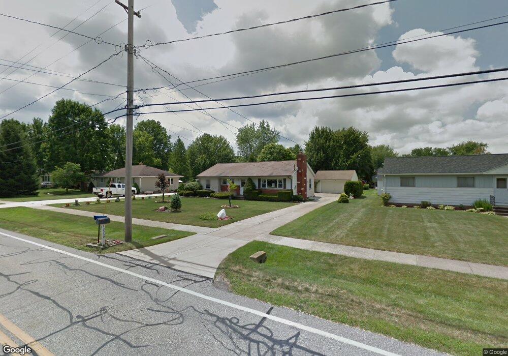
1978 Bassett Rd Westlake, OH 44145
Estimated Value: $274,676 - $418,000
3
Beds
2
Baths
1,417
Sq Ft
$237/Sq Ft
Est. Value
About This Home
This home is located at 1978 Bassett Rd, Westlake, OH 44145 and is currently estimated at $335,419, approximately $236 per square foot. 1978 Bassett Rd is a home located in Cuyahoga County with nearby schools including Dover Intermediate School, Lee Burneson Middle School, and Westlake High School.
Ownership History
Date
Name
Owned For
Owner Type
Purchase Details
Closed on
Oct 15, 2021
Sold by
Jean A Allen Declaration Of Trust
Bought by
Roland B Allen Declaration Of Trust
Current Estimated Value
Purchase Details
Closed on
Oct 30, 2014
Sold by
Allen Roland B and Allen Jean A
Bought by
Jean A Allen Declaration Of Trust and Allen Roland B
Purchase Details
Closed on
Apr 2, 1985
Sold by
Allen Roland B and Allen Jean A
Bought by
Allen Roland B and Allen Jean A
Purchase Details
Closed on
Jan 1, 1975
Bought by
Allen Roland B and Allen Jean A
Create a Home Valuation Report for This Property
The Home Valuation Report is an in-depth analysis detailing your home's value as well as a comparison with similar homes in the area
Home Values in the Area
Average Home Value in this Area
Purchase History
| Date | Buyer | Sale Price | Title Company |
|---|---|---|---|
| Roland B Allen Declaration Of Trust | -- | Higgins Robert M | |
| Jean A Allen Declaration Of Trust | -- | Attorney | |
| Allen Roland B | -- | -- | |
| Allen Roland B | -- | -- |
Source: Public Records
Tax History Compared to Growth
Tax History
| Year | Tax Paid | Tax Assessment Tax Assessment Total Assessment is a certain percentage of the fair market value that is determined by local assessors to be the total taxable value of land and additions on the property. | Land | Improvement |
|---|---|---|---|---|
| 2024 | $3,791 | $89,810 | $18,235 | $71,575 |
| 2023 | $3,111 | $65,320 | $16,770 | $48,550 |
| 2022 | $3,084 | $65,310 | $16,770 | $48,550 |
| 2021 | $3,276 | $68,740 | $16,770 | $51,980 |
| 2020 | $2,975 | $58,730 | $14,320 | $44,420 |
| 2019 | $2,885 | $167,800 | $40,900 | $126,900 |
| 2018 | $2,855 | $58,730 | $14,320 | $44,420 |
| 2017 | $2,844 | $54,890 | $11,800 | $43,090 |
| 2016 | $2,828 | $54,890 | $11,800 | $43,090 |
| 2015 | $2,514 | $54,890 | $11,800 | $43,090 |
| 2014 | $2,514 | $49,010 | $10,540 | $38,470 |
Source: Public Records
Map
Nearby Homes
- 2075 Bassett Rd
- 29379 Detroit Rd
- 29363 Detroit Rd Unit 5
- 1476 Bobby Ln Unit 7
- 28167 Zinfandel Ct
- 28163 Zinfandel Ct
- 1625 Cedarwood Dr Unit 218
- Ashton Plan at Hope Pointe Place
- Bowman Plan at Hope Pointe Place
- 2647 Piedmont Ct Unit 56
- 1721 Merlot Ln
- 28180 Detroit Rd Unit A2
- 1670 Cedarwood Dr Unit 148
- 1510 Alder Ln Unit 7C
- 1480 Cedarwood Dr Unit 21F
- 27923 Hilliard Blvd
- 1316 Cedarwood Dr Unit D3
- 31035 Wilderness Trail
- 31000 Logan Ct
- 0 Hilliard Blvd Unit 5128276
- 1996 Bassett Rd
- 1960 Bassett Rd
- 29219 Sunset Dr
- 2050 Bassett Rd
- 1936 Bassett Rd
- 29235 Sunset Dr
- 2008 Farmington Turn
- 2025 Bassett Rd
- 1959 Bassett Rd
- 2062 Bassett Rd
- 2049 Bassett Rd
- 1937 Bassett Rd
- 1990 Farmington Turn
- 2026 Farmington Turn
- 29251 Sunset Dr
- 1916 Bassett Rd
- 29218 Sunset Dr
- 2061 Bassett Rd
- 29234 Sunset Dr
- 1917 Bassett Rd