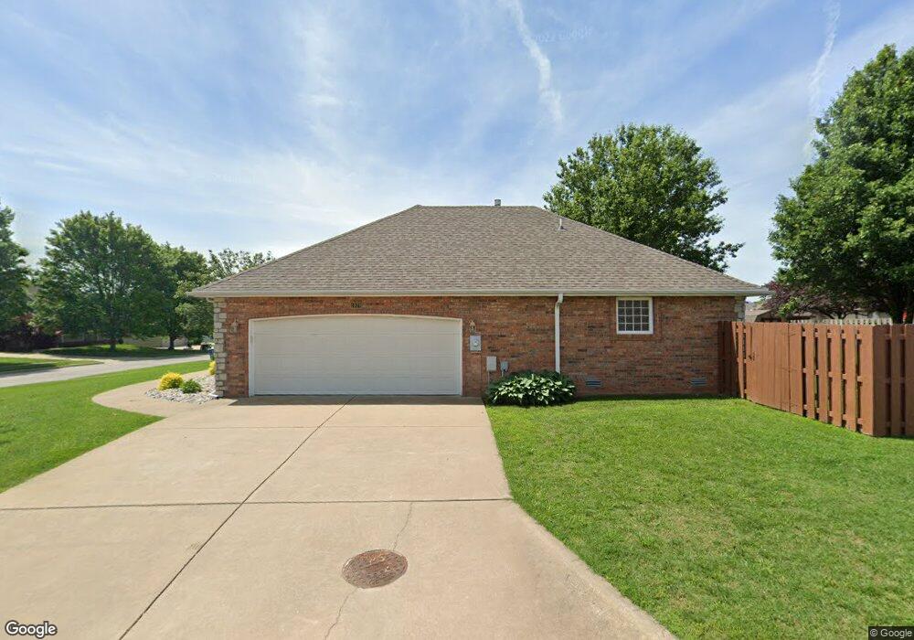
1978 E Wheatridge Dr Springfield, MO 65803
Estimated Value: $296,797 - $339,000
3
Beds
2
Baths
1,833
Sq Ft
$173/Sq Ft
Est. Value
About This Home
This home is located at 1978 E Wheatridge Dr, Springfield, MO 65803 and is currently estimated at $316,949, approximately $172 per square foot. 1978 E Wheatridge Dr is a home located in Greene County with nearby schools including Pleasant View K-8 School, Hillcrest High School, and Dayspring Christian School.
Ownership History
Date
Name
Owned For
Owner Type
Purchase Details
Closed on
Sep 9, 2011
Sold by
Bateman Homer Lee and Bateman Retha I
Bought by
Boley Gregory L
Current Estimated Value
Purchase Details
Closed on
May 5, 2009
Sold by
Hawkins Wayne and Hawkins Janice K
Bought by
Johnston Retha
Home Financials for this Owner
Home Financials are based on the most recent Mortgage that was taken out on this home.
Original Mortgage
$25,000
Interest Rate
5.03%
Mortgage Type
Purchase Money Mortgage
Purchase Details
Closed on
Mar 7, 2005
Sold by
Deckard Dale and Deckard Cathy
Bought by
Hawkins Wayne and Hawkins Janice K
Home Financials for this Owner
Home Financials are based on the most recent Mortgage that was taken out on this home.
Original Mortgage
$24,675
Interest Rate
5.66%
Mortgage Type
Stand Alone Second
Create a Home Valuation Report for This Property
The Home Valuation Report is an in-depth analysis detailing your home's value as well as a comparison with similar homes in the area
Purchase History
| Date | Buyer | Sale Price | Title Company |
|---|---|---|---|
| Boley Gregory L | -- | None Available | |
| Johnston Retha | -- | None Available | |
| Hawkins Wayne | -- | None Available |
Source: Public Records
Mortgage History
| Date | Status | Borrower | Loan Amount |
|---|---|---|---|
| Previous Owner | Johnston Retha | $25,000 | |
| Previous Owner | Hawkins Wayne | $24,675 | |
| Previous Owner | Hawkins Wayne | $131,600 |
Source: Public Records
Tax History
| Year | Tax Paid | Tax Assessment Tax Assessment Total Assessment is a certain percentage of the fair market value that is determined by local assessors to be the total taxable value of land and additions on the property. | Land | Improvement |
|---|---|---|---|---|
| 2025 | $2,419 | $44,730 | $7,700 | $37,030 |
| 2024 | $2,277 | $39,330 | $5,700 | $33,630 |
| 2023 | $2,265 | $39,330 | $5,700 | $33,630 |
| 2022 | $2,096 | $35,660 | $5,700 | $29,960 |
| 2021 | $2,004 | $35,660 | $5,700 | $29,960 |
| 2020 | $2,027 | $34,240 | $5,700 | $28,540 |
| 2019 | $1,971 | $34,240 | $5,700 | $28,540 |
| 2018 | $1,806 | $31,220 | $5,320 | $25,900 |
| 2017 | $1,789 | $31,220 | $5,320 | $25,900 |
| 2016 | $1,786 | $31,220 | $5,320 | $25,900 |
| 2015 | $1,773 | $31,220 | $5,320 | $25,900 |
| 2014 | $1,751 | $30,860 | $5,320 | $25,540 |
Source: Public Records
Map
Nearby Homes
- 1923 E Valley Water Mill Rd
- 2393 E Valley Water Mill Rd
- 3839 N Stewart Ave
- 3424 N Darwin Ave
- 3975 N Stewart Ave
- 4260 N State Highway H
- Tract C N Farm Road 173
- 3749 N Pickwick Ave
- 3753 N Pickwick Ave
- 3983 N Courtney Cir
- 4541b N Lanier Ln
- 4541 N Lanier Ln
- 3333 N Delaware Ave
- 1349 E Stoneridge St
- 3538 N Prince Ln
- 3107 N Neergard Ave
- 1270 E Ogorman Ct
- 1502 E McClernon St
- 1414 E Smith St
- 1255 E Bonaire Dr
- 3763 N Mill Ridge Ave
- 1972 E Wheatridge Dr
- 1977 E Wheatridge Dr
- 3760 N Nias Ave
- 3751 N Mill Ridge Ave
- 3774 N Mill Ridge Ave
- 1971 E Wheatridge Dr
- 3762 N Mill Ridge Ave
- 3748 N Nias Ave
- 3815 N Mill Ridge Ave
- 1989 E Wheatridge Dr
- 3750 N Mill Ridge Ave
- 1965 E Wheatridge Dr
- 3739 N Mill Ridge Ave
- 3814 N Mill Ridge Ave
- 3736 N Nias Ave
- 1996 E Wheatridge Dr
- 3765 N Valley Place
- 3827 N Mill Ridge Ave
- 1970 E Burntwood Dr
Your Personal Tour Guide
Ask me questions while you tour the home.