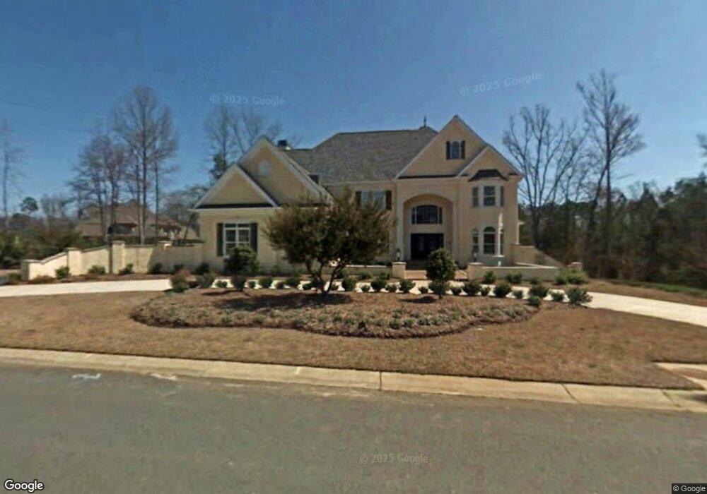
1978 Landry Ln Rock Hill, SC 29732
Estimated Value: $999,000 - $1,265,399
5
Beds
7
Baths
7,272
Sq Ft
$158/Sq Ft
Est. Value
About This Home
This home is located at 1978 Landry Ln, Rock Hill, SC 29732 and is currently estimated at $1,151,600, approximately $158 per square foot. 1978 Landry Ln is a home located in York County with nearby schools including Rawlinson Road Middle School, Northwestern High School, and York Preparatory Academy.
Ownership History
Date
Name
Owned For
Owner Type
Purchase Details
Closed on
Aug 23, 2013
Sold by
Scbt Na
Bought by
Johal Kuldip S and Kuldip S Johal Living Trust
Current Estimated Value
Purchase Details
Closed on
Jul 17, 2013
Sold by
Howell James and Howell James A
Bought by
Scbt Na and South Carolina Bank & Trust Of The Piedm
Purchase Details
Closed on
Feb 12, 2009
Sold by
Howell James A and Howell Phyllis L
Bought by
Meadow Lakes Ii Homeowners Association I
Purchase Details
Closed on
Jun 14, 2005
Sold by
Howell James A and Howell Phyllis L
Bought by
Howell James A and Howell Phyllis L
Purchase Details
Closed on
Jul 23, 2004
Sold by
Meadow Lakes Partners
Bought by
Howell James A and Howell Phyllis L
Create a Home Valuation Report for This Property
The Home Valuation Report is an in-depth analysis detailing your home's value as well as a comparison with similar homes in the area
Home Values in the Area
Average Home Value in this Area
Purchase History
| Date | Buyer | Sale Price | Title Company |
|---|---|---|---|
| Johal Kuldip S | $663,990 | -- | |
| Scbt Na | $700,000 | -- | |
| Meadow Lakes Ii Homeowners Association I | -- | -- | |
| Howell James A | -- | -- | |
| Howell James A | $82,000 | -- |
Source: Public Records
Tax History Compared to Growth
Tax History
| Year | Tax Paid | Tax Assessment Tax Assessment Total Assessment is a certain percentage of the fair market value that is determined by local assessors to be the total taxable value of land and additions on the property. | Land | Improvement |
|---|---|---|---|---|
| 2024 | $6,787 | $30,936 | $4,180 | $26,756 |
| 2023 | $6,806 | $30,936 | $4,180 | $26,756 |
| 2022 | $6,852 | $30,936 | $4,180 | $26,756 |
| 2021 | -- | $30,936 | $4,180 | $26,756 |
| 2020 | $6,939 | $31,257 | $0 | $0 |
| 2019 | $6,224 | $27,180 | $0 | $0 |
| 2018 | $6,216 | $27,180 | $0 | $0 |
| 2017 | $5,988 | $27,180 | $0 | $0 |
| 2016 | $5,933 | $27,180 | $0 | $0 |
| 2014 | $6,523 | $27,180 | $3,800 | $23,380 |
| 2013 | $6,523 | $27,180 | $3,800 | $23,380 |
Source: Public Records
Map
Nearby Homes
- 1594 Summit View Dr
- 2069 Landry Ln Unit 233
- 1593 Worthington Crossing
- 2076 Landry Ln Unit 232
- 1189 Quiet Acres Rd
- 1548 Summit View Dr
- 2765 Dogwood Cir
- 1183 Quiet Acres Rd
- 1487 The Crossing
- 2615 Oakhurst Dr
- 1122 Wendy Rd
- 985 Montgomery Dr
- 1768 Williamsburg Dr
- 829 Rawlinson Rd
- 893 Woodway Ln
- 609 Rosemore Place
- 926 Meadow Lakes Rd
- 1939 Hendricks St
- 1925 Hendricks St
- 1085 Pinecrest Dr
- 1968 Landry Ln
- 1988 Landry Ln
- 1988 Landry Ln
- 1979 Landry Ln
- 1687 Nestledown Ct
- 1989 Landry Ln
- 1999 Landry Ln
- 1969 Landry Ln
- 1958 Landry Ln
- 1986 Farrow Dr
- 1976 Farrow Dr
- 1976 Farrow Dr Unit 208
- 2009 Landry Ln
- Lot 267 Landry Ln
- Lot 264 Landry Ln
- 1694 Nestledown Ct
- 1966 Farrow Dr
- 1686 Nestledown Ct
- 1678 Nestledown Ct
- 1948 Landry Ln