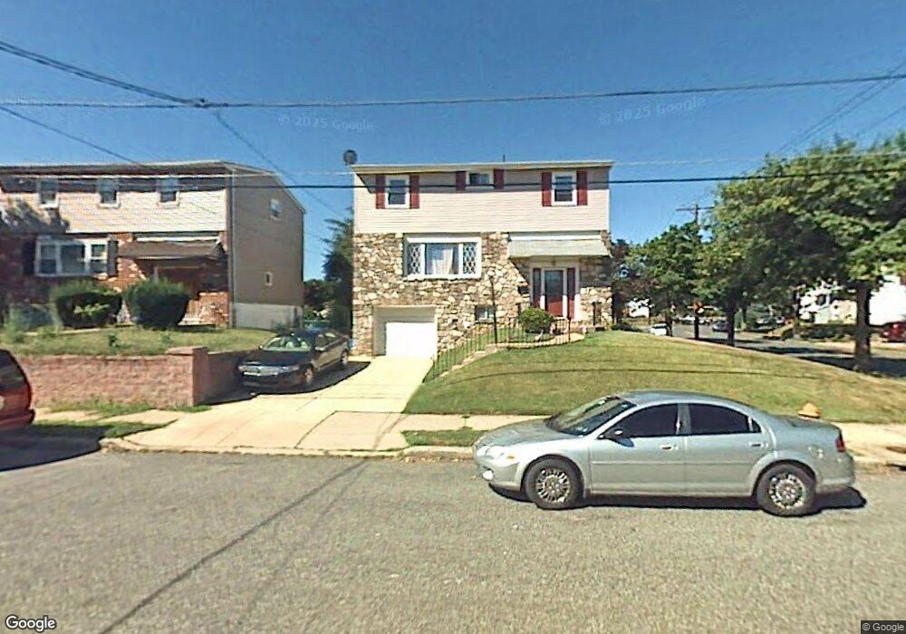
1979 Merlin Rd Philadelphia, PA 19116
Somerton NeighborhoodEstimated Value: $403,259 - $522,000
--
Bed
--
Bath
1,728
Sq Ft
$278/Sq Ft
Est. Value
About This Home
This home is located at 1979 Merlin Rd, Philadelphia, PA 19116 and is currently estimated at $480,065, approximately $277 per square foot. 1979 Merlin Rd is a home located in Philadelphia County with nearby schools including Frank Anne School, CCA Baldi Middle School, and George Washington High School.
Ownership History
Date
Name
Owned For
Owner Type
Purchase Details
Closed on
Nov 17, 2014
Sold by
Grosso Donald J and Jamison Evelyn
Bought by
Jamison Evelyn
Current Estimated Value
Purchase Details
Closed on
May 21, 2007
Sold by
Jamison Evelyn
Bought by
Grosso Donald J and Jamison Evelyn
Purchase Details
Closed on
Apr 27, 1999
Sold by
Tourlitis John and Tourlitis Stamatia
Bought by
Jamison Evelyn
Create a Home Valuation Report for This Property
The Home Valuation Report is an in-depth analysis detailing your home's value as well as a comparison with similar homes in the area
Home Values in the Area
Average Home Value in this Area
Purchase History
| Date | Buyer | Sale Price | Title Company |
|---|---|---|---|
| Jamison Evelyn | -- | None Available | |
| Grosso Donald J | -- | None Available | |
| Jamison Evelyn | $140,000 | -- |
Source: Public Records
Tax History Compared to Growth
Tax History
| Year | Tax Paid | Tax Assessment Tax Assessment Total Assessment is a certain percentage of the fair market value that is determined by local assessors to be the total taxable value of land and additions on the property. | Land | Improvement |
|---|---|---|---|---|
| 2025 | $4,722 | $421,200 | $84,240 | $336,960 |
| 2024 | $4,722 | $421,200 | $84,240 | $336,960 |
| 2023 | $4,722 | $337,300 | $67,460 | $269,840 |
| 2022 | $3,283 | $292,300 | $67,460 | $224,840 |
| 2021 | $3,912 | $0 | $0 | $0 |
| 2020 | $3,912 | $0 | $0 | $0 |
| 2019 | $3,746 | $0 | $0 | $0 |
| 2018 | $3,420 | $0 | $0 | $0 |
| 2017 | $3,420 | $0 | $0 | $0 |
| 2016 | $3,000 | $0 | $0 | $0 |
| 2015 | $2,872 | $0 | $0 | $0 |
| 2014 | -- | $244,300 | $95,472 | $148,828 |
| 2012 | -- | $34,144 | $10,875 | $23,269 |
Source: Public Records
Map
Nearby Homes
- 10123 Alexandra Ln
- 1912 Tomlinson Rd
- 1829 Tomlinson Rd
- 1724 Nathaniel Dr
- 2044 Gorman St
- 1207 Friel Place
- 9990 Sandy Rd
- 9987 Hardy Rd
- 9926 00 Haldeman Ave
- 9926 Haldeman Unit#133 Ave
- 9926 Haldeman Ave
- 9839 Haldeman Ave
- 9921 Bustleton Ave Unit K11
- 9921 Bustleton Ave Unit P3
- 9837 Haldeman Ave
- 11003 Stevens Rd
- 831 Lawler St
- 9823 Bonner St
- 9908 Bustleton Ave Unit H23
- 9908 00 Bustleton Ave Unit F9
- 1977 Merlin Rd
- 10129 Clark St
- 1975 Merlin Rd
- 10127 Clark Place
- 1992 King Arthur Rd
- 10122 Clark St
- 1990 King Arthur Rd
- 10120 Clark St
- 1973 King Arthur Rd
- 1971 King Arthur Rd
- 10125 Clark Place
- 1988 King Arthur Rd
- 10118 Clark St
- 1867 Merlin Rd
- 1969 King Arthur Rd
- 1986 King Arthur Rd
- 1902 Greymont St
- 1868 Merlin Place
- 10123 Clark Place
- 1865 Merlin Rd