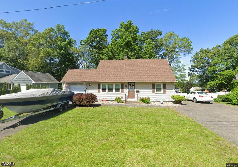
198 E Allen Ridge Rd Springfield, MA 01118
East Forest Park NeighborhoodEstimated Value: $308,269 - $331,000
3
Beds
1
Bath
1,428
Sq Ft
$224/Sq Ft
Est. Value
About This Home
This home is located at 198 E Allen Ridge Rd, Springfield, MA 01118 and is currently estimated at $319,817, approximately $223 per square foot. 198 E Allen Ridge Rd is a home located in Hampden County with nearby schools including Frederick Harris Elementary School, M Marcus Kiley Middle, and Springfield High School of Science and Technology.
Ownership History
Date
Name
Owned For
Owner Type
Purchase Details
Closed on
Jun 19, 2002
Sold by
Tower Robert E and Tower Fay I
Bought by
Bazinet-Lavallee L
Current Estimated Value
Home Financials for this Owner
Home Financials are based on the most recent Mortgage that was taken out on this home.
Original Mortgage
$76,000
Outstanding Balance
$32,134
Interest Rate
6.81%
Mortgage Type
Purchase Money Mortgage
Estimated Equity
$287,683
Create a Home Valuation Report for This Property
The Home Valuation Report is an in-depth analysis detailing your home's value as well as a comparison with similar homes in the area
Home Values in the Area
Average Home Value in this Area
Purchase History
| Date | Buyer | Sale Price | Title Company |
|---|---|---|---|
| Bazinet-Lavallee L | $100,000 | -- |
Source: Public Records
Mortgage History
| Date | Status | Borrower | Loan Amount |
|---|---|---|---|
| Open | Bazinet-Lavallee L | $76,000 |
Source: Public Records
Tax History
| Year | Tax Paid | Tax Assessment Tax Assessment Total Assessment is a certain percentage of the fair market value that is determined by local assessors to be the total taxable value of land and additions on the property. | Land | Improvement |
|---|---|---|---|---|
| 2025 | $4,278 | $272,800 | $49,300 | $223,500 |
| 2024 | $4,286 | $266,900 | $49,300 | $217,600 |
| 2023 | $4,462 | $261,700 | $47,000 | $214,700 |
| 2022 | $3,644 | $193,600 | $47,000 | $146,600 |
| 2021 | $3,398 | $179,800 | $42,700 | $137,100 |
| 2020 | $3,224 | $165,100 | $42,700 | $122,400 |
| 2019 | $3,289 | $167,100 | $42,700 | $124,400 |
| 2018 | $2,959 | $154,100 | $42,700 | $111,400 |
| 2017 | $2,959 | $150,500 | $42,700 | $107,800 |
| 2016 | $2,800 | $142,400 | $42,700 | $99,700 |
| 2015 | $2,844 | $144,600 | $42,700 | $101,900 |
Source: Public Records
Map
Nearby Homes
- 46 Hadley St
- 119 Powell Ave
- 125 Manor Ct Unit 125
- 206 Treetop Ave
- 19 Manor Ct Unit 19
- 13 Bither St
- 55 Allen St
- 1088 Sumner Ave
- 17 Pebble Mill Rd
- 161 Dorset St
- 79 Roosevelt Ave
- 34 Castle St
- 79 Arvilla St
- 26 Dwight Rd
- 78 Wood Ave
- 77 Dorset St
- 38 Manchester Terrace
- 101 Regal St
- 88 Brunswick St
- 134 Eddywood St
- 188 E Allen Ridge Rd
- 204 E Allen Ridge Rd
- 205 W Allen Ridge Rd
- 197 W Allen Ridge Rd
- 211 W Allen Ridge Rd Unit 1
- 180 E Allen Ridge Rd
- 195 E Allen Ridge Rd
- 191 W Allen Ridge Rd
- 213 E Allen Ridge Rd
- 219 W Allen Ridge Rd
- 210 E Allen Ridge Rd
- 187 E Allen Ridge Rd
- 181 W Allen Ridge Rd
- 172 E Allen Ridge Rd
- 216 E Allen Ridge Rd
- 227 W Allen Ridge Rd
- 7 Audley Rd
- 206 Mount Holly Dr
- 216 Mount Holly Dr
- 222 E Allen Ridge Rd
Your Personal Tour Guide
Ask me questions while you tour the home.