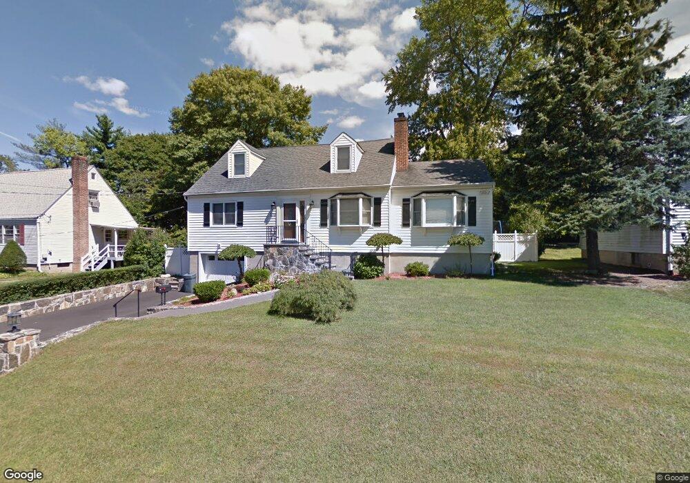
198 Willis Ave Hawthorne, NY 10532
Estimated Value: $787,444 - $922,000
3
Beds
1
Bath
2,161
Sq Ft
$394/Sq Ft
Est. Value
About This Home
This home is located at 198 Willis Ave, Hawthorne, NY 10532 and is currently estimated at $851,861, approximately $394 per square foot. 198 Willis Ave is a home located in Westchester County with nearby schools including Hawthorne Elementary School, Columbus Elementary School, and Westlake Middle School.
Ownership History
Date
Name
Owned For
Owner Type
Purchase Details
Closed on
Dec 19, 2006
Sold by
Fresta Robert and Fresta Lorraine
Bought by
Gromulat Daniel and Gromulat Gina
Current Estimated Value
Home Financials for this Owner
Home Financials are based on the most recent Mortgage that was taken out on this home.
Original Mortgage
$500,000
Outstanding Balance
$296,447
Interest Rate
6.16%
Mortgage Type
Purchase Money Mortgage
Estimated Equity
$555,414
Create a Home Valuation Report for This Property
The Home Valuation Report is an in-depth analysis detailing your home's value as well as a comparison with similar homes in the area
Home Values in the Area
Average Home Value in this Area
Purchase History
| Date | Buyer | Sale Price | Title Company |
|---|---|---|---|
| Gromulat Daniel | $625,000 | Stewart Title Insurance Co |
Source: Public Records
Mortgage History
| Date | Status | Borrower | Loan Amount |
|---|---|---|---|
| Open | Gromulat Daniel | $500,000 |
Source: Public Records
Tax History Compared to Growth
Tax History
| Year | Tax Paid | Tax Assessment Tax Assessment Total Assessment is a certain percentage of the fair market value that is determined by local assessors to be the total taxable value of land and additions on the property. | Land | Improvement |
|---|---|---|---|---|
| 2024 | $14,909 | $7,450 | $1,000 | $6,450 |
| 2023 | $14,462 | $7,450 | $1,000 | $6,450 |
| 2022 | $14,205 | $7,450 | $1,000 | $6,450 |
| 2021 | $13,930 | $7,450 | $1,000 | $6,450 |
| 2020 | $13,664 | $7,450 | $1,000 | $6,450 |
| 2019 | $14,849 | $7,450 | $1,000 | $6,450 |
| 2018 | $15,454 | $7,450 | $1,000 | $6,450 |
| 2017 | $4,453 | $7,450 | $1,000 | $6,450 |
| 2016 | $13,362 | $7,450 | $1,000 | $6,450 |
| 2015 | -- | $7,450 | $1,000 | $6,450 |
| 2014 | -- | $7,450 | $1,000 | $6,450 |
| 2013 | -- | $7,450 | $1,000 | $6,450 |
Source: Public Records
Map
Nearby Homes
- 237 Brady Ave
- 233 Brady Ave
- 32 Weed Ave
- 317 Elwood Ave
- 350 Commerce St
- 404 Manhattan Ave
- 14 Aspen Way
- 16 Highclere Ln Unit A
- 116 Rolling Hills Rd
- 00 Belleview Ave
- 324 Tuxedo Place
- 7 Fountain Dr
- 66 Leroy Ave
- 179A Lakeview Ave
- 1 Eunice Ln
- 24 Burnsdale Ave
- 3 Rolling Hills Rd
- 14 Halsey Place
- 865 Commerce St
- Lot 92 Columbus Ave
- 202 Willis Ave
- 196 Willis Ave
- 199 Manhattan Ave
- 204 Willis Ave
- 197 Manhattan Ave
- 201 Willis Ave
- 197 Willis Ave
- 203 Manhattan Ave
- 203 Willis Ave
- 190 Willis Ave
- 206 Willis Ave
- 205 Willis Ave
- 191 Manhattan Ave
- 207 Manhattan Ave
- 191 Willis Ave
- 198 Manhattan Ave
- 200 Marietta Ave
- 200 Manhattan Ave
- 196 Manhattan Ave
- 196 Marietta Ave