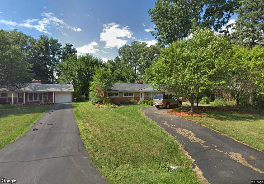
1980 Devonshire Rd Bloomfield Hills, MI 48302
Estimated Value: $292,468 - $370,000
3
Beds
2
Baths
1,508
Sq Ft
$219/Sq Ft
Est. Value
About This Home
This home is located at 1980 Devonshire Rd, Bloomfield Hills, MI 48302 and is currently estimated at $330,367, approximately $219 per square foot. 1980 Devonshire Rd is a home located in Oakland County with nearby schools including Eastover Elementary School, Bloomfield Hills High School, and Arts & Technology Academy of Pontiac.
Ownership History
Date
Name
Owned For
Owner Type
Purchase Details
Closed on
Jan 30, 2006
Sold by
Sacco Dean and Sacco Cynthia L
Bought by
Mcdonald Christopher M
Current Estimated Value
Home Financials for this Owner
Home Financials are based on the most recent Mortgage that was taken out on this home.
Original Mortgage
$166,300
Outstanding Balance
$92,782
Interest Rate
6.34%
Mortgage Type
New Conventional
Estimated Equity
$237,585
Purchase Details
Closed on
Aug 30, 2001
Sold by
Petz Patricia M
Bought by
Sacco Dean
Home Financials for this Owner
Home Financials are based on the most recent Mortgage that was taken out on this home.
Original Mortgage
$156,250
Interest Rate
6.92%
Create a Home Valuation Report for This Property
The Home Valuation Report is an in-depth analysis detailing your home's value as well as a comparison with similar homes in the area
Home Values in the Area
Average Home Value in this Area
Purchase History
| Date | Buyer | Sale Price | Title Company |
|---|---|---|---|
| Mcdonald Christopher M | $207,900 | Metro Title Corp | |
| Sacco Dean | $157,500 | -- |
Source: Public Records
Mortgage History
| Date | Status | Borrower | Loan Amount |
|---|---|---|---|
| Open | Mcdonald Christopher M | $166,300 | |
| Previous Owner | Sacco Dean | $156,250 |
Source: Public Records
Tax History
| Year | Tax Paid | Tax Assessment Tax Assessment Total Assessment is a certain percentage of the fair market value that is determined by local assessors to be the total taxable value of land and additions on the property. | Land | Improvement |
|---|---|---|---|---|
| 2025 | $3,258 | $134,120 | $29,950 | $104,170 |
| 2024 | $1,638 | $134,120 | $0 | $0 |
| 2023 | $1,562 | $120,510 | $0 | $0 |
| 2022 | $2,928 | $106,410 | $0 | $0 |
| 2021 | $2,851 | $103,080 | $0 | $0 |
| 2020 | $1,377 | $97,720 | $0 | $0 |
| 2019 | $2,729 | $88,910 | $0 | $0 |
| 2018 | $2,625 | $86,570 | $0 | $0 |
| 2017 | $2,584 | $83,220 | $0 | $0 |
| 2016 | $2,576 | $77,160 | $0 | $0 |
| 2015 | -- | $70,710 | $0 | $0 |
| 2014 | -- | $58,000 | $0 | $0 |
| 2011 | -- | $50,230 | $0 | $0 |
Source: Public Records
Map
Nearby Homes
- 256 E Highland Ave
- 1661 Winthrop Rd
- 95 Hillsdale Rd
- 2307 Bedford Rd
- 62 Barrington Rd
- 2449 Mulberry Square Unit 28
- 0000 Devon Rd
- 2738 Berry Dr
- 454 Fox Hills Dr N
- 42160 Woodward Ave Unit 8
- 42160 Woodward Ave Unit 17
- 42160 Woodward Ave Unit 86
- 200 Cedardale Ave
- 187 Nebraska Ave
- 44784 Woodward Ave
- 0000 Central Ave
- 2724 Alveston Dr
- 256 Cedardale Ave
- 82 Earlmoor Blvd
- 2863 Meadowood Ln
- 1964 Devonshire Rd
- 1996 Devonshire Rd
- 1948 Devonshire Rd
- 2012 Devonshire Rd
- 290 E Berkshire Rd
- 1997 Devonshire Rd
- 1979 Devonshire Rd
- 1932 Devonshire Rd Unit Bldg-Unit
- 1932 Devonshire Rd
- 2017 Devonshire Rd
- 276 E Berkshire Rd
- 2028 Devonshire Rd
- 2035 Devonshire Rd
- 1949 Devonshire Rd
- 1916 Devonshire Rd
- 2067 Devonshire Rd
- 2044 Devonshire Rd
- 2180 Lancaster Rd
- 2170 Lancaster Rd
- 1933 Devonshire Rd
Your Personal Tour Guide
Ask me questions while you tour the home.