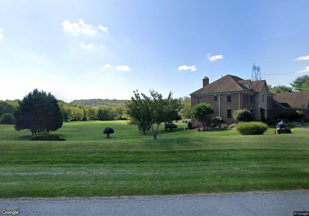
19801 Tanbark Way Brinklow, MD 20862
Estimated Value: $1,210,000 - $1,382,000
--
Bed
4
Baths
5,318
Sq Ft
$241/Sq Ft
Est. Value
About This Home
This home is located at 19801 Tanbark Way, Brinklow, MD 20862 and is currently estimated at $1,281,817, approximately $241 per square foot. 19801 Tanbark Way is a home located in Montgomery County with nearby schools including Sherwood Elementary School, William H. Farquhar Middle School, and Sherwood High School.
Ownership History
Date
Name
Owned For
Owner Type
Purchase Details
Closed on
Jan 19, 1999
Sold by
Marisabel Mathison
Bought by
M Lou A and M Boozer M
Current Estimated Value
Purchase Details
Closed on
Oct 21, 1996
Sold by
C Ary S and C Smith P
Bought by
Marisabel Mathison
Create a Home Valuation Report for This Property
The Home Valuation Report is an in-depth analysis detailing your home's value as well as a comparison with similar homes in the area
Home Values in the Area
Average Home Value in this Area
Purchase History
| Date | Buyer | Sale Price | Title Company |
|---|---|---|---|
| M Lou A | -- | -- | |
| Marisabel Mathison | $135,000 | -- |
Source: Public Records
Tax History Compared to Growth
Tax History
| Year | Tax Paid | Tax Assessment Tax Assessment Total Assessment is a certain percentage of the fair market value that is determined by local assessors to be the total taxable value of land and additions on the property. | Land | Improvement |
|---|---|---|---|---|
| 2025 | $13,411 | $1,139,433 | -- | -- |
| 2024 | $13,411 | $1,097,167 | $0 | $0 |
| 2023 | $12,194 | $1,054,900 | $318,100 | $736,800 |
| 2022 | $11,500 | $1,040,833 | $0 | $0 |
| 2021 | $11,086 | $1,026,767 | $0 | $0 |
| 2020 | $11,086 | $1,012,700 | $318,100 | $694,600 |
| 2019 | $11,061 | $1,012,700 | $318,100 | $694,600 |
| 2018 | $11,073 | $1,012,700 | $318,100 | $694,600 |
| 2017 | $11,883 | $1,066,500 | $0 | $0 |
| 2016 | -- | $1,066,500 | $0 | $0 |
| 2015 | $9,429 | $1,066,500 | $0 | $0 |
| 2014 | $9,429 | $1,138,400 | $0 | $0 |
Source: Public Records
Map
Nearby Homes
- 19800 New Hampshire Ave
- 19900 New Hampshire Ave
- 19230 Chandlee Mill Rd
- 18682 Brooke Rd
- 1600 Gold Mine Rd
- 18901 Chandlee Mill Rd
- 18671 Brooke Rd
- 231 Brinkwood Rd
- 200 Ashcroft Ct
- 7244 Mink Hollow Rd
- 18526 Brooke Rd
- 18515 Brooke Rd
- 20509 Bordly Ct
- 1000 Rocky Glen Dr
- 2454 Epstein Ct
- 21151 New Hampshire Ave
- 1625 Ashton Rd
- 20529 Riggs Hill Way
- 2444 Astrid Ct
- 211 Olney Sandy Spring Rd
- 19800 Tanbark Way
- 19805 Tanbark Way
- 19804 Tanbark Way
- 19808 Tanbark Way
- 19809 Tanbark Way
- 19816 Tanbark Way
- 19813 Tanbark Way
- 19820 Tanbark Way
- 504 Tanbark Ct
- 413 Windswept Ln
- New Hampshire Ave
- 19817 Tanbark Way
- 19824 Tanbark Way
- 19515 New Hampshire Ave
- 513 Tanbark Ct
- 19821 Tanbark Way
- 19808 Pinebark Way
- 401 Windswept Ln
- 7654 Mris-Prod-respepa Ave
- 19301 New Hampshire Ave