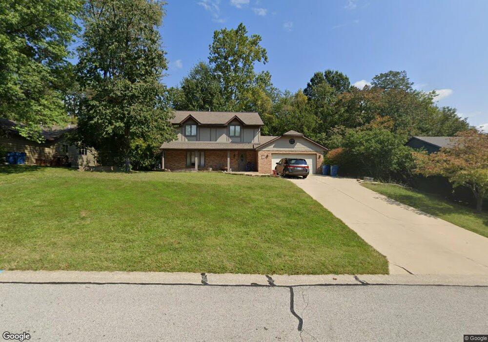
1982 Mapleleaf Dr Collinsville, IL 62234
Estimated Value: $288,000 - $340,000
4
Beds
3
Baths
2,196
Sq Ft
$144/Sq Ft
Est. Value
About This Home
This home is located at 1982 Mapleleaf Dr, Collinsville, IL 62234 and is currently estimated at $316,205, approximately $143 per square foot. 1982 Mapleleaf Dr is a home located in Madison County with nearby schools including John A Renfro Elementary School, Dorris Intermediate School, and Collinsville Middle School.
Ownership History
Date
Name
Owned For
Owner Type
Purchase Details
Closed on
Dec 11, 2009
Sold by
Deutsche Bank National Trust Company
Bought by
Morrison Christopher J
Current Estimated Value
Home Financials for this Owner
Home Financials are based on the most recent Mortgage that was taken out on this home.
Original Mortgage
$118,000
Interest Rate
5%
Mortgage Type
New Conventional
Purchase Details
Closed on
Mar 6, 2009
Sold by
Aguayo Rafael
Bought by
Deutsche Bank National Trust Company
Purchase Details
Closed on
Oct 8, 2003
Sold by
Mueller Warren M and Mueller Diane R
Bought by
Aguayo Rafael and Aguayo Maria
Home Financials for this Owner
Home Financials are based on the most recent Mortgage that was taken out on this home.
Original Mortgage
$164,880
Interest Rate
8.5%
Mortgage Type
Unknown
Create a Home Valuation Report for This Property
The Home Valuation Report is an in-depth analysis detailing your home's value as well as a comparison with similar homes in the area
Home Values in the Area
Average Home Value in this Area
Purchase History
| Date | Buyer | Sale Price | Title Company |
|---|---|---|---|
| Morrison Christopher J | $147,500 | Servicelink | |
| Deutsche Bank National Trust Company | -- | None Available | |
| Aguayo Rafael | $183,500 | Abstracts & Titles Inc |
Source: Public Records
Mortgage History
| Date | Status | Borrower | Loan Amount |
|---|---|---|---|
| Previous Owner | Morrison Christopher J | $118,000 | |
| Previous Owner | Aguayo Rafael | $164,880 |
Source: Public Records
Tax History
| Year | Tax Paid | Tax Assessment Tax Assessment Total Assessment is a certain percentage of the fair market value that is determined by local assessors to be the total taxable value of land and additions on the property. | Land | Improvement |
|---|---|---|---|---|
| 2024 | $5,293 | $88,800 | $17,600 | $71,200 |
| 2023 | $5,293 | $82,190 | $16,290 | $65,900 |
| 2022 | $5,014 | $76,000 | $15,060 | $60,940 |
| 2021 | $4,518 | $71,400 | $14,150 | $57,250 |
| 2020 | $4,360 | $68,470 | $13,360 | $55,110 |
| 2019 | $4,231 | $66,130 | $12,900 | $53,230 |
| 2018 | $4,122 | $62,640 | $12,220 | $50,420 |
| 2017 | $4,120 | $61,400 | $11,980 | $49,420 |
| 2016 | $4,329 | $61,400 | $11,980 | $49,420 |
| 2015 | $4,593 | $67,360 | $13,380 | $53,980 |
| 2014 | $4,593 | $67,360 | $13,380 | $53,980 |
| 2013 | $4,593 | $67,360 | $13,380 | $53,980 |
Source: Public Records
Map
Nearby Homes
- 10 White Birch Ln
- 2010 Raintree Trail
- 4 Cedar Point
- 2019 Raintree Trail
- 804 Oran St
- 2033 Mapleleaf Dr
- 19 Pine Lake Dr
- 30 Saint Rose Dr
- 110 Linda Dr
- 1404 Olive St
- 102 3rd St
- 204 Emery St
- 1202 State St
- 1511 Franklin Ave
- 38 Lakeview Acres Dr
- 104 Rex Dr
- 910 Portland Ave
- 718 Osborn Dr
- 625 W Country Ln
- 320 Garesche St
- 1980 Mapleleaf Dr
- 1984 Mapleleaf Dr
- 10 Oak Leaf Cir
- 1978 Mapleleaf Dr
- 8 Oak Leaf Cir
- 1979 Mapleleaf Dr
- 1981 Mapleleaf Dr
- 1986 Mapleleaf Dr
- 1977 Mapleleaf Dr
- 12 Oak Leaf Cir
- 6 Oak Leaf Cir
- 1988 Mapleleaf Dr
- 1976 Mapleleaf Dr
- 1983 Mapleleaf Dr
- 4 Oak Leaf Cir
- 11 Oak Leaf Cir
- 7 Oak Leaf Cir
- 1975 Mapleleaf Dr
- 1973 Mapleleaf Dr
- 5 Oak Leaf Cir
Your Personal Tour Guide
Ask me questions while you tour the home.