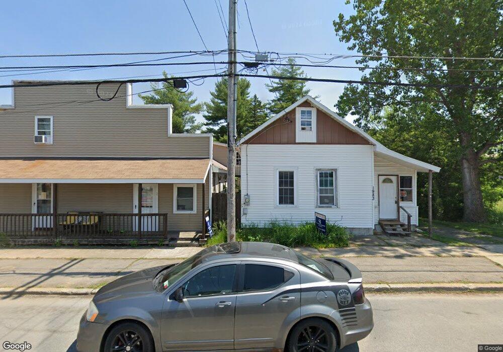
1983 State Highway 11c North Lawrence, NY 12967
Estimated Value: $46,000 - $138,000
4
Beds
2
Baths
1,720
Sq Ft
$57/Sq Ft
Est. Value
About This Home
This home is located at 1983 State Highway 11c, North Lawrence, NY 12967 and is currently estimated at $97,348, approximately $56 per square foot. 1983 State Highway 11c is a home with nearby schools including St. Lawrence Elementary School, St. Lawrence Middle School, and St. Lawrence High School.
Ownership History
Date
Name
Owned For
Owner Type
Purchase Details
Closed on
Oct 2, 2018
Sold by
Seguin Carrie J
Bought by
Kimball William J and Betz Carl A
Current Estimated Value
Home Financials for this Owner
Home Financials are based on the most recent Mortgage that was taken out on this home.
Original Mortgage
$106,400
Interest Rate
3.6%
Mortgage Type
Future Advance Clause Open End Mortgage
Purchase Details
Closed on
Jun 10, 2013
Sold by
Seguin Rick W
Bought by
Seguin Carrie J
Purchase Details
Closed on
Feb 2, 2001
Sold by
Eldridge Deanna
Bought by
Eldridge Mark W
Create a Home Valuation Report for This Property
The Home Valuation Report is an in-depth analysis detailing your home's value as well as a comparison with similar homes in the area
Home Values in the Area
Average Home Value in this Area
Purchase History
| Date | Buyer | Sale Price | Title Company |
|---|---|---|---|
| Kimball William J | $133,000 | None Available | |
| Seguin Carrie J | -- | None Available | |
| Eldridge Mark W | -- | -- |
Source: Public Records
Mortgage History
| Date | Status | Borrower | Loan Amount |
|---|---|---|---|
| Previous Owner | Kimball William J | $106,400 |
Source: Public Records
Tax History Compared to Growth
Tax History
| Year | Tax Paid | Tax Assessment Tax Assessment Total Assessment is a certain percentage of the fair market value that is determined by local assessors to be the total taxable value of land and additions on the property. | Land | Improvement |
|---|---|---|---|---|
| 2024 | $1,856 | $47,800 | $4,800 | $43,000 |
| 2023 | $1,854 | $47,800 | $4,800 | $43,000 |
| 2022 | $1,830 | $47,800 | $4,800 | $43,000 |
| 2021 | $1,768 | $46,800 | $3,800 | $43,000 |
| 2020 | $1,798 | $46,800 | $3,800 | $43,000 |
| 2019 | $1,227 | $46,800 | $3,800 | $43,000 |
| 2018 | $1,227 | $46,800 | $3,800 | $43,000 |
| 2017 | $1,211 | $46,800 | $3,800 | $43,000 |
| 2016 | $1,253 | $46,800 | $3,800 | $43,000 |
| 2015 | -- | $46,800 | $3,800 | $43,000 |
| 2014 | -- | $46,800 | $3,800 | $43,000 |
Source: Public Records
Map
Nearby Homes
- 2194 New York 11c
- 0 Sh 11 C Unit 51026
- 00 Rd
- 00 W Cotter Rd Parcel A
- 00 W Cotter Rd Parcel B
- 1364 County Route 55
- 00 W Cotter Rd Parcel C
- 151 W Cotter Rd
- 11057 Ush 11
- 1472 Sh 11 C
- 1105 County Route 54
- 0 County Route 55 Unit 204114
- 1426 State Highway 11c
- 196 County Road 50
- 00 Mcewen Rd
- 49 County Route 50
- 59 George St
- 164 Barnage Rd
- 0 Lawrence Rd Unit 51016
- 0 Off Sh 37c
- 1983 Sh 11c
- 1979 New York 11c
- 1979 State Highway 11c
- 1977 State Highway 11c
- 1985 State Highway 11c
- 1969 Sh 11 C
- 0 Ush 11 Unit 21531
- 0 Ush 11 Unit 24074
- off 11-C 11-C
- 0 New York 11c
- 1965 State Highway 11c
- 1965 State Highway 11c Unit 1 & 2
- 1964 State Highway 11c
- 1999 State Highway 11c
- 6 Desmond St
- 6 Grove St
- 2002 State Highway 11c
- 17 County Route 52
- 17 Cr 52
- 8 Desmond St Unit 12