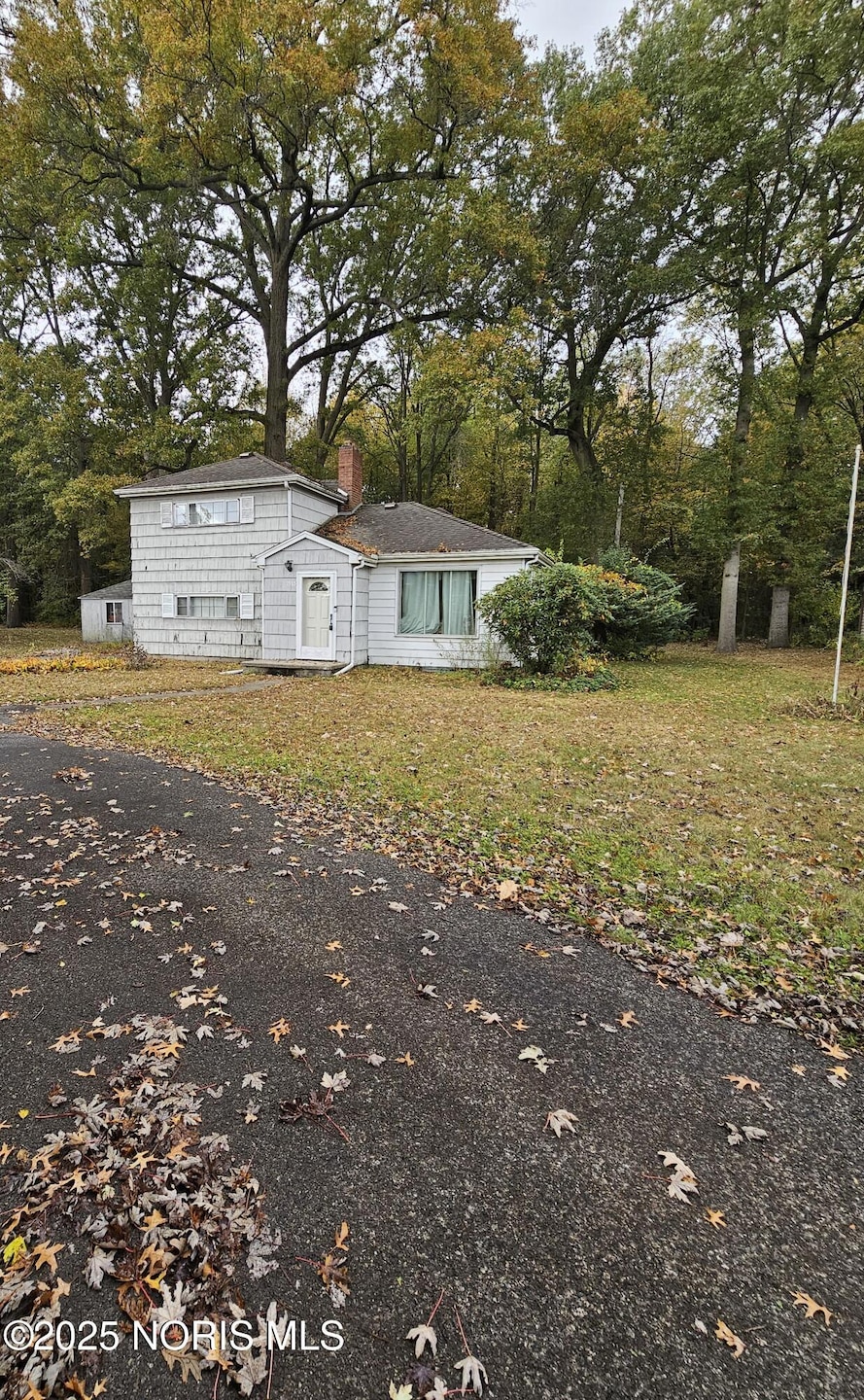
1985 Oakhaven Rd Toledo, OH 43615
Reynolds Corners NeighborhoodHighlights
- Wooded Lot
- Circular Driveway
- Wood Siding
- Traditional Architecture
- Forced Air Heating System
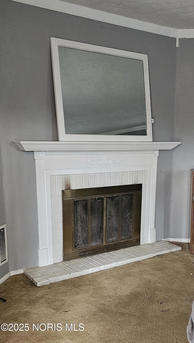
- Wood Burning Fireplace
About This Home
Online Only Toledo Real Estate Auction Thursday November 13, 2025 beginning to end at 6PM! Investment Opportunity! 2 Bedroom, 1 1⁄2 Bath 2 Story Home situated on a wooded lot and located on a dead end street. Large Storage building and off street parking! Selling to settle the Estate of Dennis J. Stallbaum Case NO. 2025 EST 1608. A Minimum starting bid of $25,000.00. A 10% buyers premium will be added to the established final price.
Home Details
Home Type
- Single Family
Est. Annual Taxes
- $1,659
Year Built
- Built in 1951
Lot Details
- 0.33 Acre Lot
- Lot Dimensions are 106x135
- Wooded Lot
Home Design
- Traditional Architecture
- Shingle Roof
- Wood Siding
- Vinyl Siding
Interior Spaces
- 1,300 Sq Ft Home
- 2-Story Property
- Wood Burning Fireplace
- Fireplace With Glass Doors
- Family Room with Fireplace
- Carpet
- Dishwasher
Bedrooms and Bathrooms
- 2 Bedrooms
Laundry
- Laundry on main level
- Washer and Electric Dryer Hookup
Parking
- Circular Driveway
- Off-Street Parking
Outdoor Features
- Outbuilding
Schools
- Hawkins Elementary School
- Rogers High School
Utilities
- No Cooling
- Forced Air Heating System
- Heating System Uses Natural Gas
Listing and Financial Details
- Assessor Parcel Number 20-24351
Map
Home Values in the Area
Average Home Value in this Area
Tax History
| Year | Tax Paid | Tax Assessment Tax Assessment Total Assessment is a certain percentage of the fair market value that is determined by local assessors to be the total taxable value of land and additions on the property. | Land | Improvement |
|---|---|---|---|---|
| 2024 | $1,659 | $51,800 | $10,255 | $41,545 |
| 2023 | $2,433 | $35,105 | $6,895 | $28,210 |
| 2022 | $2,402 | $35,105 | $6,895 | $28,210 |
| 2021 | $2,485 | $35,105 | $6,895 | $28,210 |
| 2020 | $2,492 | $30,625 | $5,950 | $24,675 |
| 2019 | $2,407 | $30,625 | $5,950 | $24,675 |
| 2018 | $2,442 | $30,625 | $5,950 | $24,675 |
| 2017 | $2,413 | $29,925 | $5,810 | $24,115 |
| 2016 | $2,440 | $85,500 | $16,600 | $68,900 |
| 2015 | $2,471 | $85,500 | $16,600 | $68,900 |
| 2014 | $1,882 | $29,930 | $5,810 | $24,120 |
| 2013 | $1,882 | $29,930 | $5,810 | $24,120 |
Property History
| Date | Event | Price | List to Sale | Price per Sq Ft |
|---|---|---|---|---|
| 10/24/2025 10/24/25 | For Sale | -- | -- | -- |
Purchase History
| Date | Type | Sale Price | Title Company |
|---|---|---|---|
| Interfamily Deed Transfer | -- | Attorney | |
| Warranty Deed | $56,000 | -- | |
| Fiduciary Deed | $51,000 | -- |
Mortgage History
| Date | Status | Loan Amount | Loan Type |
|---|---|---|---|
| Open | $63,800 | New Conventional |
Source: Northwest Ohio Real Estate Information Service (NORIS)
MLS Number: 10000580
APN: 20-24351
Disclaimer: Certain information contained herein is derived from information provided by parties other than Homes.com. All information provided is deemed reliable, but is not guaranteed to be accurate and should be independently verified.
![]() IDX information is provided exclusively for personal, non-commercial use, and may not be used for any purpose other than to identify prospective properties consumers may be interested in purchasing. Information is deemed reliable but not guaranteed. ©2025 NORIS. All rights reserved.
IDX information is provided exclusively for personal, non-commercial use, and may not be used for any purpose other than to identify prospective properties consumers may be interested in purchasing. Information is deemed reliable but not guaranteed. ©2025 NORIS. All rights reserved.
- 2015 Oakside Rd
- 2010 Oakside Rd
- 2004 Oakside Rd
- 1954 Devinci Dr
- 1709 Acorn Dr
- 1810 Birdie Dr
- 2206 Farm View Ct Unit 2206
- 405 N Holland Sylvania Rd
- 1930 Birkdale Rd
- 1916 Birkdale Rd
- 6237 Dorr St
- 5665 Camberley Dr
- 2113 Broadstone Rd
- 5743 Candlestick Ct E
- 1032 Saturn Dr
- 2515 Orchard Hills Blvd
- 6124 Applegate St
- 2523 Briarwood Ln
- 827 N Holland Sylvania Rd
- 2412 McKivett Dr
- 2161 Orchard Lakes Place
- 2241 Vaness Dr
- 2411 N Holland Sylvania Rd
- 6300-6318 W Bancroft St
- 5739 Dorr St
- 1940 Woodbridge Rd
- 1009 N Holland Sylvania Rd
- 2015 N Mccord Rd
- 1017 Heidelberg Rd
- 2759 Pin Oak Dr
- 6705 W Bancroft St
- 5610 Hogan Ave Unit 19
- 6951 W Bancroft St
- 2704 Westmar Ct
- 5123 Newhart Cir
- 5035 Wissman Rd
- 1599 Twin Oaks Dr
- 2123 Eileen Rd
- 4804 W Bancroft St
- 1314 Linden Ln
