


19860 US Highway 63 Grand View, WI 54839
Estimated payment $1,763/month
Highlights
- 131 Acre Lot
- Wooded Lot
- Lot Has A Rolling Slope
About This Lot
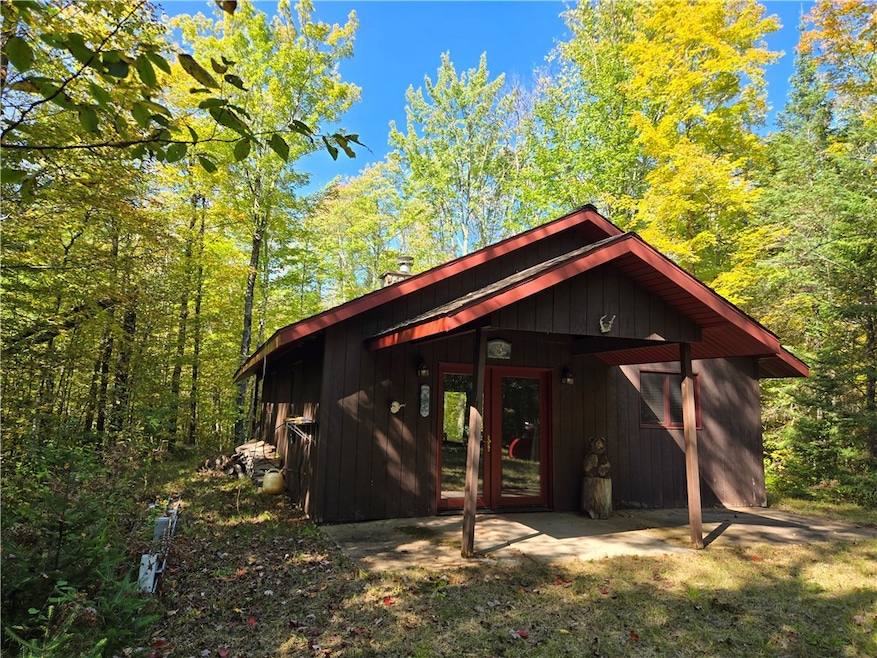
Great hunting land with a mix of hardwoods and aspen, with a stream, pond, and wetlands. Established trails and a fantastic one-room cabin with fireplace. Great land for deer, grouse, turkey, ducks, and bear. Three enclosed tower stands established. Located between Drummond and Grand View, the property is easily accessible off US Hwy 63. The greater area is a year-round outdoor paradise with trails for ATV, snowmobile, skiing, biking. Numerous lakes and streams offer fishing and boating opportunities. You will find yourself escaping hear throughout the year.
Listing Agent
McKinney Realty LLC Brokerage Phone: 715-798-3445 License #46244-94 Listed on: 09/25/2025
Property Details
Property Type
- Land
Est. Annual Taxes
- $2,392
Lot Details
- 131 Acre Lot
- Lot Has A Rolling Slope
- Wooded Lot
- Zoning described as Forestry
Utilities
- Water Not Available
- Sewer Not Available
Listing and Financial Details
- Assessor Parcel Number 17410
Map
Home Values in the Area
Average Home Value in this Area
Tax History
| Year | Tax Paid | Tax Assessment Tax Assessment Total Assessment is a certain percentage of the fair market value that is determined by local assessors to be the total taxable value of land and additions on the property. | Land | Improvement |
|---|---|---|---|---|
| 2024 | $1,168 | $106,100 | $73,300 | $32,800 |
| 2023 | $905 | $106,100 | $73,300 | $32,800 |
| 2022 | $801 | $106,100 | $73,300 | $32,800 |
| 2021 | $832 | $106,100 | $73,300 | $32,800 |
| 2020 | $827 | $106,100 | $73,300 | $32,800 |
| 2019 | $891 | $106,100 | $73,300 | $32,800 |
| 2018 | $820 | $106,100 | $73,300 | $32,800 |
| 2017 | $874 | $106,100 | $73,300 | $32,800 |
| 2016 | $990 | $106,100 | $73,300 | $32,800 |
| 2015 | $1,125 | $119,800 | $87,000 | $32,800 |
| 2013 | $1,220 | $119,800 | $87,000 | $32,800 |
Property History
| Date | Event | Price | Change | Sq Ft Price |
|---|---|---|---|---|
| 09/25/2025 09/25/25 | For Sale | $295,000 | -- | -- |
Source: Northwestern Wisconsin Multiple Listing Service
MLS Number: 1595942
APN: 04-021-2-45-06-19-4-03-000-10000
Disclaimer: Certain information contained herein is derived from information provided by parties other than Homes.com. All information provided is deemed reliable, but is not guaranteed to be accurate and should be independently verified.
![]() IDX information is provided exclusively for personal, non-commercial use, and may not be used for any purpose other than to identify prospective properties consumers may be interested in purchasing. Information is deemed reliable but not guaranteed.
IDX information is provided exclusively for personal, non-commercial use, and may not be used for any purpose other than to identify prospective properties consumers may be interested in purchasing. Information is deemed reliable but not guaranteed.
- 54350 & 54390 Arnie Carlson Rd
- 54555 County Highway D
- 545XX County Highway D
- 53935 County Highway D
- 22655 Sunset Acres Ln
- 85435 Old 13 Rd
- 52605 Eastern Ave
- 52530 Owen Ave
- 51595 Wisco Rd
- xxxx Mason Delta Rd
- 47660 N Diamond Lake Dr
- 445XX Club Lake Rd
- 59460 Main St
- 23520 Faith Church Rd
- 46415 Crystal Lake Rd
- ON N Altamont Rd
- 16990 County Highway H
- 42XXX County Hwy E
- 46095 W Tahkodah Lake Rd
- 28370 Kyster Rd
