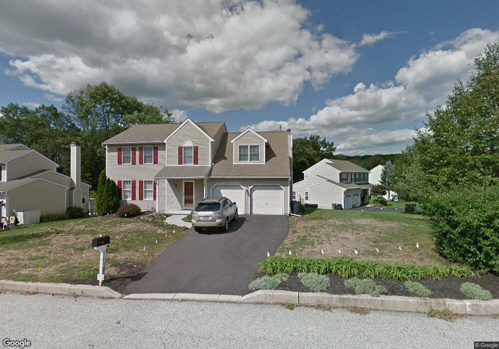
1987 Summit Way Pottstown, PA 19464
Estimated Value: $475,000 - $494,000
4
Beds
3
Baths
2,246
Sq Ft
$218/Sq Ft
Est. Value
About This Home
This home is located at 1987 Summit Way, Pottstown, PA 19464 and is currently estimated at $488,715, approximately $217 per square foot. 1987 Summit Way is a home located in Montgomery County with nearby schools including Lower Pottsgrove Elementary School, Pottsgrove Middle School, and Pottsgrove Senior High School.
Ownership History
Date
Name
Owned For
Owner Type
Purchase Details
Closed on
Dec 19, 2001
Sold by
Duncan Garrett M and Duncan Margaret H
Bought by
Brennan Jason H and Brennan Keri A
Current Estimated Value
Purchase Details
Closed on
May 29, 1998
Sold by
Reader Charles T and Reader Mary Beth
Bought by
Duncan Garrett M and Duncan Margaret H
Purchase Details
Closed on
Apr 7, 1997
Sold by
Pleasantview Estates
Bought by
Reader Charles T and Reader Mary Beth
Create a Home Valuation Report for This Property
The Home Valuation Report is an in-depth analysis detailing your home's value as well as a comparison with similar homes in the area
Home Values in the Area
Average Home Value in this Area
Purchase History
| Date | Buyer | Sale Price | Title Company |
|---|---|---|---|
| Brennan Jason H | $178,000 | -- | |
| Duncan Garrett M | $151,000 | -- | |
| Reader Charles T | $151,449 | -- |
Source: Public Records
Tax History Compared to Growth
Tax History
| Year | Tax Paid | Tax Assessment Tax Assessment Total Assessment is a certain percentage of the fair market value that is determined by local assessors to be the total taxable value of land and additions on the property. | Land | Improvement |
|---|---|---|---|---|
| 2025 | $7,484 | $152,270 | $33,740 | $118,530 |
| 2024 | $7,484 | $152,270 | $33,740 | $118,530 |
| 2023 | $7,252 | $152,270 | $33,740 | $118,530 |
| 2022 | $7,144 | $152,270 | $33,740 | $118,530 |
| 2021 | $7,003 | $152,270 | $33,740 | $118,530 |
| 2020 | $6,939 | $152,270 | $33,740 | $118,530 |
| 2019 | $6,902 | $152,270 | $33,740 | $118,530 |
| 2018 | $6,902 | $152,270 | $33,740 | $118,530 |
| 2017 | $6,842 | $152,270 | $33,740 | $118,530 |
| 2016 | $6,783 | $152,270 | $33,740 | $118,530 |
| 2015 | $6,629 | $152,270 | $33,740 | $118,530 |
| 2014 | $6,629 | $152,270 | $33,740 | $118,530 |
Source: Public Records
Map
Nearby Homes
- 3605 Walnut Ridge Dr
- 3204 Walnut Ridge Estate
- 2126 Deer Ridge Dr
- 1103 Walnut Ridge Dr
- 1876 Glen Eagles Dr
- 1532 Briarwood Ln
- 1527 Cedar Hill Rd
- 1240 Wooded Way
- 1871 Linda Ln
- 1769 Clearview Rd
- 1814 N Keim St
- 17 Doe Run Ln
- 1330 N Sanatoga Rd
- 277 N Pleasantview Rd
- 260 Hause Ave
- 1267 Ringing Rocks Park
- 1131 Crestwood Dr
- 1108 Bleim Rd
- 233 Creekside Dr
- 2600 Allison Dr Unit 5
- 1985 Summit Way
- 1989 Deer Ridge Dr
- 1969 Deer Ridge Dr
- 1991 Deer Ridge Dr
- 2006 Deer Ridge Dr
- 2008 Deer Ridge Dr
- 1971 Summit Way Unit 12
- 1973 Summit Way
- 1993 Deer Ridge Dr
- 2010 Deer Ridge Dr
- 2004 Deer Ridge Dr
- 1967 Deer Ridge Dr
- 1981 Summit Way
- 1975 Summit Way
- 1965 Deer Ridge Dr
- 2012 Deer Ridge Dr
- 2002 Deer Ridge Dr
- 1995 Deer Ridge Dr
- 1977 Summit Way
- 1963 Deer Ridge Dr