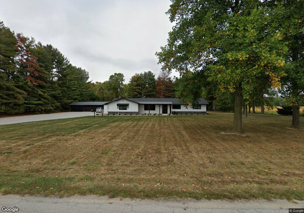
1989 County Road 60 Auburn, IN 46706
Estimated Value: $367,000 - $433,000
3
Beds
3
Baths
2,160
Sq Ft
$183/Sq Ft
Est. Value
About This Home
This home is located at 1989 County Road 60, Auburn, IN 46706 and is currently estimated at $394,781, approximately $182 per square foot. 1989 County Road 60 is a home located in DeKalb County with nearby schools including J.E. Ober Elementary School, Garrett Middle School, and Garrett High School.
Ownership History
Date
Name
Owned For
Owner Type
Purchase Details
Closed on
Aug 24, 2020
Sold by
Miller George Alfred and Miller Carolyn F
Bought by
Steury Philip P and Steury Loretta K
Current Estimated Value
Home Financials for this Owner
Home Financials are based on the most recent Mortgage that was taken out on this home.
Original Mortgage
$165,000
Outstanding Balance
$146,367
Interest Rate
3%
Mortgage Type
New Conventional
Estimated Equity
$248,414
Purchase Details
Closed on
Feb 14, 2011
Sold by
Miller George Alfred
Bought by
Miller George A and Miller Carolyn F
Create a Home Valuation Report for This Property
The Home Valuation Report is an in-depth analysis detailing your home's value as well as a comparison with similar homes in the area
Home Values in the Area
Average Home Value in this Area
Purchase History
| Date | Buyer | Sale Price | Title Company |
|---|---|---|---|
| Steury Philip P | -- | None Available | |
| Steury Loretta K | -- | None Available | |
| Miller George A | -- | None Available |
Source: Public Records
Mortgage History
| Date | Status | Borrower | Loan Amount |
|---|---|---|---|
| Open | Steury Philip P | $165,000 |
Source: Public Records
Tax History Compared to Growth
Tax History
| Year | Tax Paid | Tax Assessment Tax Assessment Total Assessment is a certain percentage of the fair market value that is determined by local assessors to be the total taxable value of land and additions on the property. | Land | Improvement |
|---|---|---|---|---|
| 2024 | $2,156 | $333,500 | $47,200 | $286,300 |
| 2023 | $1,954 | $320,200 | $44,900 | $275,300 |
| 2022 | $1,603 | $226,800 | $38,900 | $187,900 |
| 2021 | $1,327 | $195,600 | $36,500 | $159,100 |
| 2020 | $1,100 | $195,600 | $29,000 | $166,600 |
| 2019 | $1,369 | $195,900 | $29,000 | $166,900 |
| 2018 | $1,080 | $174,300 | $22,800 | $151,500 |
| 2017 | $1,369 | $184,200 | $22,800 | $161,400 |
| 2016 | $1,107 | $172,900 | $22,800 | $150,100 |
| 2014 | $1,001 | $159,100 | $22,800 | $136,300 |
Source: Public Records
Map
Nearby Homes
- 1967 County Road 60
- 5936 County Road 427
- 2256 County Road 56
- 5937 County Road 427
- 2034 County Road 68
- 5272 Greyson Heights Dr
- 602 Pioneer St
- 508 Pioneer St
- 502 Pioneer St
- 1904 Waynedale Dr
- 502 Harold St
- 508 Sadie Place
- 16 Thornewood Dr
- Lot1 County Road 17
- Lot 13 County Road 17
- Lot 4 County Road 17
- Lot 12 County Road 17
- Lot 6 County Road 17
- Lot 9 County Road 17
- Lot 10 County Road 17
- 2014 County Road 60
- 1941 County Road 60
- 1996 County Road 60
- 1916 County Road 60
- 6087 County Road 11a
- 6018 County Road 11a
- 5963 County Road 11a
- 2108 County Road 60
- 60 Cr
- 2089 County Road 60
- 2131 County Road 60
- 1844 County Road 60
- 2137 County Road 60
- 0 County Road 60
- 0000 County Road 60
- 2141 County Road 60
- 2150 County Road 60
- 1826 County Road 60
- 2159 County Road 60
- 6082 County Road 11a