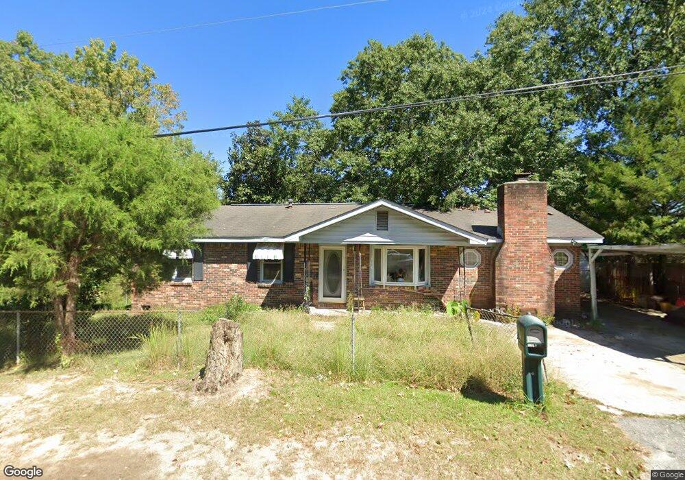
199 Aster Cir Columbia, SC 29201
Arthurtown NeighborhoodEstimated Value: $116,000 - $153,000
3
Beds
1
Bath
1,300
Sq Ft
$98/Sq Ft
Est. Value
About This Home
This home is located at 199 Aster Cir, Columbia, SC 29201 and is currently estimated at $126,978, approximately $97 per square foot. 199 Aster Cir is a home located in Richland County with nearby schools including South Kilbourne Elementary School, Hand Middle School, and Dreher High School.
Ownership History
Date
Name
Owned For
Owner Type
Purchase Details
Closed on
Aug 26, 2025
Sold by
Dubose Gregory Vance
Bought by
Gd Investment Trust and Dubose
Current Estimated Value
Home Financials for this Owner
Home Financials are based on the most recent Mortgage that was taken out on this home.
Original Mortgage
$101,000
Outstanding Balance
$100,649
Interest Rate
6.75%
Mortgage Type
New Conventional
Estimated Equity
$26,329
Purchase Details
Closed on
Mar 15, 2023
Sold by
Richland County Bank
Bought by
Huff Mary D
Purchase Details
Closed on
Feb 27, 2023
Sold by
Clyburn Mignon
Bought by
Dubose Gregory Vance
Create a Home Valuation Report for This Property
The Home Valuation Report is an in-depth analysis detailing your home's value as well as a comparison with similar homes in the area
Home Values in the Area
Average Home Value in this Area
Purchase History
| Date | Buyer | Sale Price | Title Company |
|---|---|---|---|
| Gd Investment Trust | -- | None Listed On Document | |
| Huff Mary D | $23,000 | -- | |
| Dubose Gregory Vance | -- | None Listed On Document |
Source: Public Records
Mortgage History
| Date | Status | Borrower | Loan Amount |
|---|---|---|---|
| Open | Gd Investment Trust | $101,000 |
Source: Public Records
Tax History
| Year | Tax Paid | Tax Assessment Tax Assessment Total Assessment is a certain percentage of the fair market value that is determined by local assessors to be the total taxable value of land and additions on the property. | Land | Improvement |
|---|---|---|---|---|
| 2024 | $1,338 | $36,200 | $7,500 | $28,700 |
| 2023 | $1,302 | $1,348 | $0 | $0 |
| 2022 | $1,251 | $33,700 | $5,000 | $28,700 |
| 2021 | $0 | $1,350 | $0 | $0 |
| 2020 | $557 | $1,350 | $0 | $0 |
| 2019 | $523 | $1,350 | $0 | $0 |
| 2018 | $483 | $1,300 | $0 | $0 |
| 2017 | $476 | $1,300 | $0 | $0 |
| 2016 | $475 | $1,300 | $0 | $0 |
| 2015 | $467 | $1,300 | $0 | $0 |
| 2014 | $459 | $32,400 | $0 | $0 |
| 2013 | -- | $1,300 | $0 | $0 |
Source: Public Records
Map
Nearby Homes
- 1218 Walcott St
- 1213 Walcott St
- 1929 Bluff Rd Unit 1
- 1522 Hibiscus St
- 1514 Dahlia Rd
- 1514 Hibiscus St
- 1504 Dahlia Rd
- 1634 S Beltline Blvd
- 116 Rose Dr
- 1455 Aralia Dr
- 100 Rose Dr
- 1450 Ilex St
- 1637 Tall Pines Cir
- 1344 S Ott Rd
- 1801 Tall Pines Cir
- 1545 S Beltline Blvd
- 1433 Aralia Dr
- 4106 Boxwood Dr
- 1425 Laburnum Dr
- 4101 Boxwood Dr
Your Personal Tour Guide
Ask me questions while you tour the home.