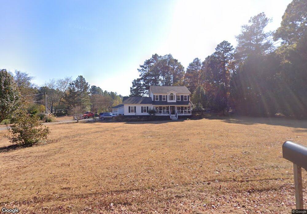
199 Curtis Cemetery Rd SE Calhoun, GA 30701
Estimated Value: $302,458 - $344,000
3
Beds
3
Baths
1,920
Sq Ft
$168/Sq Ft
Est. Value
About This Home
This home is located at 199 Curtis Cemetery Rd SE, Calhoun, GA 30701 and is currently estimated at $321,615, approximately $167 per square foot. 199 Curtis Cemetery Rd SE is a home located in Gordon County with nearby schools including Belwood Elementary School, Red Bud Middle School, and Sonoraville High School.
Ownership History
Date
Name
Owned For
Owner Type
Purchase Details
Closed on
Jul 8, 2011
Sold by
Federal National Mortgage Association
Bought by
Lawson Travis Jared
Current Estimated Value
Purchase Details
Closed on
Sep 7, 2010
Sold by
Sturgill Samuel J and Sturgill Stacey B
Bought by
Chase Home Finance Llc
Purchase Details
Closed on
Mar 31, 2004
Sold by
Tomlinson Eddy
Bought by
Sturgill Samuel J and Sturgill Stacey B
Purchase Details
Closed on
Dec 12, 2001
Sold by
Sovereign Bank
Bought by
Tomlinson Eddy
Purchase Details
Closed on
Dec 4, 2001
Sold by
Ridings Forrest W
Bought by
Sovereign Bank
Purchase Details
Closed on
Sep 24, 1999
Bought by
Ridings Forrest W
Purchase Details
Closed on
Nov 21, 1997
Bought by
Ridings Forest W and Ridings Anita R
Purchase Details
Closed on
Apr 12, 1995
Bought by
Nix Rachel
Create a Home Valuation Report for This Property
The Home Valuation Report is an in-depth analysis detailing your home's value as well as a comparison with similar homes in the area
Home Values in the Area
Average Home Value in this Area
Purchase History
| Date | Buyer | Sale Price | Title Company |
|---|---|---|---|
| Lawson Travis Jared | $124,000 | -- | |
| Chase Home Finance Llc | $169,500 | -- | |
| Federal National Mortgage Association | $169,534 | -- | |
| Chase Home Finance Llc | $169,534 | -- | |
| Sturgill Samuel J | $159,900 | -- | |
| Tomlinson Eddy | -- | -- | |
| Sovereign Bank | -- | -- | |
| Ridings Forrest W | -- | -- | |
| Ridings Forest W | $128,900 | -- | |
| Nix Rachel | $12,000 | -- |
Source: Public Records
Tax History Compared to Growth
Tax History
| Year | Tax Paid | Tax Assessment Tax Assessment Total Assessment is a certain percentage of the fair market value that is determined by local assessors to be the total taxable value of land and additions on the property. | Land | Improvement |
|---|---|---|---|---|
| 2024 | $2,167 | $87,280 | $3,680 | $83,600 |
| 2023 | $2,023 | $81,640 | $3,680 | $77,960 |
| 2022 | $2,007 | $76,280 | $3,680 | $72,600 |
| 2021 | $1,693 | $62,440 | $3,680 | $58,760 |
| 2020 | $1,752 | $63,160 | $3,680 | $59,480 |
| 2019 | $1,762 | $63,160 | $3,680 | $59,480 |
| 2018 | $1,629 | $58,560 | $3,680 | $54,880 |
Source: Public Records
Map
Nearby Homes
- 00 Curtis Cir
- 0 Curtis Cir SE Unit 10611011
- 0 Curtis Cir SE Unit 7654260
- 0 Lovers Lane Rd SE Unit 10509663
- 220 Porch Loop SE
- 111 Lewis Dr SE
- 201 Porch Loop SE
- 0 Richardson Rd SE Unit 10474273
- 0 Richardson Rd SE Unit 7537183
- 251 Tucker Hollow Rd SE
- 133 Kensington Dr SE
- 252 Blackwood Place SE
- 106 Kensington Dr SE
- The Alston Plan at Salacoa - The Overlook at Salacoa
- The Hartwell Plan at Salacoa - The Overlook at Salacoa
- The Perry Plan at Salacoa - The Overlook at Salacoa
- The Dalton Plan at Salacoa - The Overlook at Salacoa
- The Springfield Plan at Salacoa - The Overlook at Salacoa
- The Dexter Plan at Salacoa - The Overlook at Salacoa
- 306 E Belmont Dr
- 185 Curtis Cemetery Rd SE
- 134 Curtis Cir SE
- 198 Curtis Cemetery Rd SE
- 157 Curtis Cemetery Rd SE
- 169 Curtis Cemetery Rd SE
- 108 Curtis Cir SE
- 208 Old Fairmount Hwy SE
- 156 Curtis Cemetery Rd SE
- 0 Curtis Cemetery Rd SE
- 147 Curtis Cemetery Rd SE
- 147 Curtis Cemetery Rd SE
- 107 SE Ccurtis Pkwy SE Unit 2
- 274 Old Fairmount Hwy SE
- 192 Old Fairmount Hwy SE
- 182 Curtis Cir SE
- 144 Curtis Cemetery Rd SE
- 1250 Lovers Lane Rd SE
- 1259 Lovers Lane Rd SE
- 303 Old Boone Ford Rd SE
- 182 Johnson Dr SE