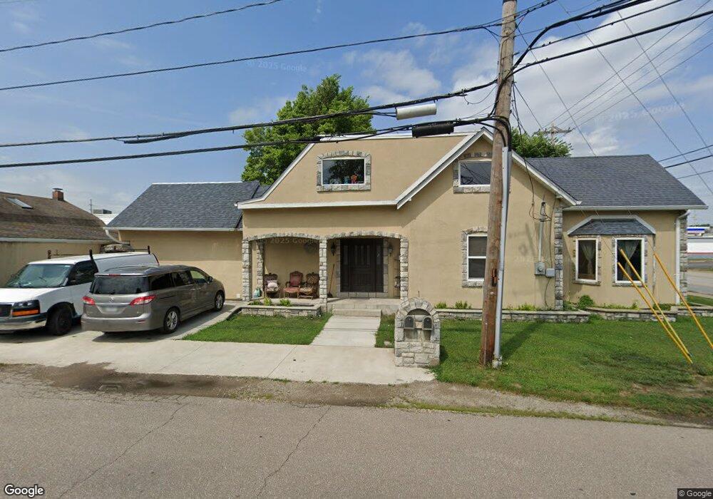
199 E Main St Whiteland, IN 46184
Estimated Value: $225,014 - $256,000
4
Beds
1
Bath
1,679
Sq Ft
$146/Sq Ft
Est. Value
About This Home
This home is located at 199 E Main St, Whiteland, IN 46184 and is currently estimated at $245,254, approximately $146 per square foot. 199 E Main St is a home with nearby schools including Whiteland Elementary School, Clark-Pleasant Middle School, and Whiteland Community High School.
Ownership History
Date
Name
Owned For
Owner Type
Purchase Details
Closed on
Apr 1, 2013
Sold by
Mcintire Donna C
Bought by
Santillan Fernando and Santillan Joanna
Current Estimated Value
Home Financials for this Owner
Home Financials are based on the most recent Mortgage that was taken out on this home.
Original Mortgage
$70,000
Interest Rate
3.46%
Mortgage Type
Unknown
Purchase Details
Closed on
Jan 11, 2006
Sold by
Mcintire Don
Bought by
Mcintire Donna C and Mcintire Don
Create a Home Valuation Report for This Property
The Home Valuation Report is an in-depth analysis detailing your home's value as well as a comparison with similar homes in the area
Home Values in the Area
Average Home Value in this Area
Purchase History
| Date | Buyer | Sale Price | Title Company |
|---|---|---|---|
| Santillan Fernando | -- | None Available | |
| Mcintire Donna C | -- | None Available |
Source: Public Records
Mortgage History
| Date | Status | Borrower | Loan Amount |
|---|---|---|---|
| Previous Owner | Santillan Fernando | $70,000 |
Source: Public Records
Tax History Compared to Growth
Tax History
| Year | Tax Paid | Tax Assessment Tax Assessment Total Assessment is a certain percentage of the fair market value that is determined by local assessors to be the total taxable value of land and additions on the property. | Land | Improvement |
|---|---|---|---|---|
| 2025 | $3,273 | $193,200 | $30,900 | $162,300 |
| 2024 | $3,273 | $155,500 | $30,900 | $124,600 |
| 2023 | $3,250 | $152,100 | $30,900 | $121,200 |
| 2022 | $2,770 | $128,600 | $20,600 | $108,000 |
| 2021 | $2,520 | $115,700 | $20,600 | $95,100 |
| 2020 | $2,378 | $107,200 | $20,600 | $86,600 |
| 2019 | $2,389 | $107,200 | $20,600 | $86,600 |
| 2018 | $3,649 | $108,300 | $15,800 | $92,500 |
| 2017 | $2,321 | $106,900 | $15,800 | $91,100 |
| 2016 | $2,272 | $102,800 | $15,800 | $87,000 |
| 2014 | $2,100 | $93,000 | $18,000 | $75,000 |
| 2013 | $2,100 | $94,100 | $18,000 | $76,100 |
Source: Public Records
Map
Nearby Homes
- 657 Whiteland Rd
- 545 Whiteland Rd
- 400 S U S Highway 31
- 320 Briar Hill Dr
- 10 Thurman Dr
- 180 Briar Hill Dr
- 229 Arlington St
- Hudson with 3-Car Garage Plan at Briar Creek - Estates
- Columbia with 3-Car Garage Plan at Briar Creek - Estates
- 213 Mcnair Rd
- Lehigh with 3-Car Garage Plan at Briar Creek - Estates
- 510 Greensprings Dr
- Aruba Bay Plan at Briar Creek - Ranches
- Grand Bahama Plan at Briar Creek - Ranches
- Dominica Spring Plan at Briar Creek - Ranches
- Grand Cayman Plan at Briar Creek - Ranches
- 338 Mcnair Rd
- 79 Gnarled Oak Ln
- 650 E Pearl St
- 630 Walnut St
- 190 Pearl St
- 230 Pearl St
- 3009 E 500 N RD Whiteland Rd
- 239 Main St
- 189 Pearl St
- 240 Pearl St
- 209 Pearl St
- 249 Main St
- 240 Pearl St
- 229 Pearl St
- 269 Pearl St
- 2 Whiteland Rd
- 002 Whiteland Rd
- 270 Pearl St
- Lot B and A U S 31
- 139 S U S 31
- 139 S U S 31
- 931 Thorpe Dr
- 20 S Us Highway 31
- 39 N Us Highway 31 Unit End Cap